Missouri Key

Missouri Key

Vorlage:Infobox Insel/Wartung/Höhe fehlt

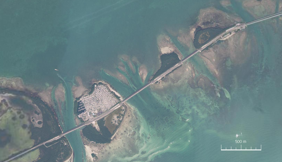
Missouri Key
Satellitenbild von Ohio Key, Missouri Key und Little Duck Key (von West nach Ost). Links unten Bahia Honda Key (Teil).
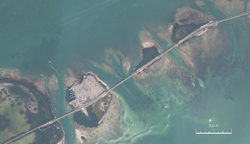
Gewässer Golf von Mexiko
Inselgruppe Florida Keys
Geographische Lage 24° 40′ 39″ N, 81° 14′ 17″ W24.6775-81.238055555556Koordinaten: 24° 40′ 39″ N, 81° 14′ 17″ W
Missouri Key (Florida)
Missouri Key
Länge 490 m
Breite 265 m
Fläche 7,7304 ha
Einwohner (unbewohnt)

Missouri Key ist eine kleine Insel der Lower Florida Keys.

Der U.S. Highway 1 (auch Overseas Highway genannt) kreuzt diese Insel bei MM 39.5. Die Insel liegt zwischen Ohio Key im Südwesten (getrennt durch den 385 Meter breiten Ohio Missouri Channel) und Little Duck Key im Nordosten (getrennt durch den 240 Meter breiten Missouri Little Duck Channel).[1] Zwischen diesen Inseln verläuft der Highway 1 auf Brücken. Entlang des Highway 1 ist die Insel 490 Meter lang. Ihre größte Breite beträgt 265 Meter.[2] Die Insel weist eine Fläche von 7,7 Hektar (77.304 m²) auf.[3] Die Insel wurde von Bauarbeitern aus Missouri während der Bauarbeiten Florida East Coast Railway nach ihrem Heimatbundesstaat benannt. Sie ist lokal auch unter den Namen Little Grassy Key oder Grassy Island bekannt.

Einzelnachweise

  1. U.S. Highway 1 Southbound - Lower Florida Keys (mit Fotos)
  2. [1] Entfernungsmessungen auf dem Satellitenbild
  3. U.S. Census 2000, Monroe County, Census Tract 9714, Blocks 6062 und 6063

Weblinks


Wikimedia Foundation.

Игры ⚽ Нужно решить контрольную?

Schlagen Sie auch in anderen Wörterbüchern nach:

  • Missouri Key — Missouri Key (en) Géographie Pays   …   Wikipédia en Français

  • Missouri Key — is a small island in the lower Florida Keys. U.S. 1 (or the Overseas Highway) crosses the key at approximately mile marker 39.5, between Ohio Key and Little Duck Key. The island was named during Henry Flagler s Overseas Railroad construction… …   Wikipedia

  • Missouri Ozark Forest Ecosystem Project — Formation 1991 Location Missouri Key people Missouri Department of C …   Wikipedia

  • Key deer — A male Key Deer on No Name Key in the Florida Keys Conservation status …   Wikipedia

  • Key Largo — Coordinates: 25°05′11″N 80°26′50″W / 25.0865°N 80.4473°W / 25.0865; 80.4473 …   Wikipedia

  • Missouri–Nebraska football rivalry — Missouri Tigers Nebraska Cornhuskers …   Wikipedia

  • Missouri Valley Community School District — is a school district in Harrison County, Iowa. Total per pupil expenditures in the Missouri Valley Community School District totals $7,115, while the state average is $7,962.[1] Missouri Valley Middle School …   Wikipedia

  • Missouri Valley Conference Men's Basketball Player of the Year — Awarded for the most outstanding basketball player in the Missouri Valley Conference Country United States …   Wikipedia

  • Missouri University of Science and Technology — Motto Salus Populi (Latin, The Welfare of the People) Established 1870 …   Wikipedia

  • Missouri Valley Conference — (MVC) Established 1907 Association NCAA …   Wikipedia

Share the article and excerpts

Direct link
Do a right-click on the link above
and select “Copy Link”