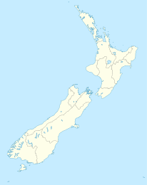
Ohaeawai

Ohaeawai
Ohaewai
Ohaewai (Neuseeland)
Ohaewai
Koordinaten 35° 21′ S, 173° 53′ O-35.351111111111173.88194444444Koordinaten: 35° 21′ S, 173° 53′ O
Einwohner 711 (2006)
Region Northland
Distrikt Far-North-Distrikt

Ohaeawai ist eine kleine Gemeinde im Far-North-Distrikt in der Region Northland auf der Nordinsel Neuseelands. Sie liegt an der Verbindungsstelle zwischen dem State Highway 1 und dem State Highway 12 etwa 250 km von Auckland entfernt. Die Schlacht von Ohaeawai fand 1845 in der Nähe der Gemeinde am von Pene Taui statt. Die Stadt Kaikohe befindet sich westlich, die Bay of Islands östlich.

Beim Zensus 2006 hatte Ohaeawai 711 Bewohner, ein Rückgang um 15 seit dem Zensus 2001.[1]

Westlich des Ortes befindet sich der kleine Kurort Ngawha Springs, der von Heilwasser in einem kleinen geothermal aktiven Gebiet profitiert. In der Nähe befindet sich auch das neue Gefängnis der Region Northland. Das Dorf ist Zentrum eines landwirtschaftlich geprägten Gebietes.

Ohaeawai besitzt eine Contributing primary school für die Klassen 1-6. Die Ohaeawai School hatte 2011 ein Decile rating von 2 und 163 Schüler.[2]

Einzelnachweise

  1. Statistics New Zealand
  2. Te Kete Ipurangi - Ohaeawai School. Ministry of Education. Abgerufen am 15. Februar 2011.

Wikimedia Foundation.

Игры ⚽ Нужно сделать НИР?

Schlagen Sie auch in anderen Wörterbüchern nach:

  • Ohaeawai — Ohaeawai …   Wikipedia

  • Schlacht von Ohaeawai — 35.3776173.85451666667 Koordinaten: 35° 22′ 39″ S, 173° 51′ 16″ O …   Deutsch Wikipedia

  • Battle of Ohaeawai — The Battle of Ohaeawai was fought between British forces and local Māori during July 1845 at Ohaeawai in the North Island of New Zealand. The battle was notable in that superior British forces were beaten by outnumbered Māori.The battle happened… …   Wikipedia

  • Flagstaff War — Infobox Military Conflict conflict=Flagstaff War partof=New Zealand Wars caption= date=11 March 1845 11 January 1846 place=Northland, New Zealand result=Stalemate combatant1= Māori allies combatant2= Ngā Puhi commander1=flagicon|United Kingdom Lt …   Wikipedia

  • New Zealand land wars — Infobox Military Conflict conflict = New Zealand Land Wars partof = caption = Memorial in the Auckland War Memorial Museum for those who died, both European and Māori, in the New Zealand Wars. Kia mate toa can be translated as fight unto death or …   Wikipedia

  • New Zealand wars — New Zealand Land Wars Memorial in the Auckland War Memorial Museum for those who died, both European and Māori, in the New Zealand Wars. Kia mate toa can be translated as fight unto death or be strong in death , and is the motto of the …   Wikipedia

  • New Zealand State Highway 12 — State Highway 12 290px Route information Maintained by New Zealand Transport Agency Length …   Wikipedia

  • Guerre de tranchées — Deux cadavres de soldats allemands gisant dans une tranchée, peints par William Orpen en 1917 La guerre de tranchée est une forme de guerre où les combattants s abritent dans des lignes fortifiées, largement constituées de tranchées dans… …   Wikipédia en Français

  • Chemical warfare — For other uses, see Chemical warfare (disambiguation). This article forms part of the series Chemical agents Lethal agents Blood agents Cyanogen chloride (CK) …   Wikipedia

  • List of battles (geographic) — This list of battles is organized geographically, by country in its present territory. For other lists of battles, see List of battles. Angola* Battle of Mbwila 1665 * Battle of Quifangondo 1975 * Battle of Cassinga 1978 * Battle of Cuito… …   Wikipedia

Share the article and excerpts

Direct link
Do a right-click on the link above
and select “Copy Link”