Pacijan

Pacijan

Vorlage:Infobox Insel/Wartung/Bild fehltVorlage:Infobox Insel/Wartung/Höhe fehlt

Pacijan
Gewässer Camotes-See
Inselgruppe Camotes-Inseln
Geographische Lage 10° 40′ N, 124° 24′ O10.666666666667124.4Koordinaten: 10° 40′ N, 124° 24′ O
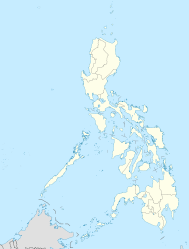
Pacijan (Philippinen)
Pacijan
Länge 18 km
Breite 15 km
Fläche 61,4 km²
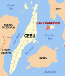
Lage von Pacijan mit der Stadtgemeinde San Francisco

Pacijan ist eine philippinische Insel und liegt in der Camotes-See zwischen den philippinischen Hauptinseln Cebu und Leyte, im Süden befindet sich Bohol.

Die Insel ist 61,4 km² groß[1] und misst ungefähr 18 km in Nord-Süd-Richtung sowie 15 km in Ost-West-Richtung. Sie gehört zur Stadtgemeinde (bayan oder municipality) San Francisco.

Pacijan gehört mit Poro, Ponson und Tulang zu den Camotes-Inseln. Das kleine Inselchen Tulang liegt im Norden. Mit der benachbarten Insel Poro direkt im Osten war sie bereits vor über 100 Jahren mit einer Brücke verbunden, heute trennt nur noch ein schmaler Meeresarm die beiden Inseln. Hier befindet sich der Hauptort San Francisco.

Im Norden der Insel befindet sich der fünf Kilometer lange See Lake Danao, in dem selbst zwei kleine Inseln liegen und an dessen Ufer zwei Parks angelegt sind. Es gibt mehrere Strände: Santiago Bay im Südosten, Bakhaw bei Esperanza und Mangodlong bei Himensulan mit einer vorgelagerten Koralleninsel.

Tulang

Ungefähr 400 m vor der Nordküste liegt die kleine Insel Tulang und erstreckt sich über 1,5 km mit einem schmalen Ende im Südosten und einem breiten Ende im Nordwesten. Die Insel gehört zum Barangay Esperanza und wie Pacijan zur Gemeinde San Francisco.

Referenzen

  1. http://islands.unep.ch/IHE.htm#1232

Wikimedia Foundation.

Игры ⚽ Нужна курсовая?

Schlagen Sie auch in anderen Wörterbüchern nach:

  • Pacijan Island — is an island that is part of the province of Cebu. Located east of Cebu Island and west of Leyte Island.San Francisco is the island s sole municipality.It is one of the four Camotes Islands along with Poro Island, Ponson Island, and Tulang Island …   Wikipedia

  • Isla de Pacijan — La isla de Pacijan es una isla que forma parte de la provincia de Cebú, Filipinas. Se encuentra al este de la isla de Cebú y al oeste de la islas de Leyte. Es una de las islas Camotes, junto con la isla de Poro, la isla de Ponson y la isla de… …   Wikipedia Español

  • Islas Camotes — (Kepulauan Camotes) Localización geográfica / administrativa Océano (mar) Mar de Camotes (Mar de Filipinas, océano Pacífico) …   Wikipedia Español

  • Camotes Islands — The Camotes Islands are a group of four islands that form part of the province of Cebu, in the Philippines. The island group is located east of Cebu Island, southwest of Leyte Island, and north of Bohol Island.The Camotes is composed of the… …   Wikipedia

  • San Francisco, Cebu — San Francisco is a 4th class municipality in the province of Cebu, Philippines. According to the 2007 census, it has a population of 44,588 people.Almost all of San Francisco is located on Pacijan Island. A part of Barangay Esperanza also… …   Wikipedia

  • Camotes-Inseln — Die Insel Ponson mit der gekennzeichneten Stadtgemeinde Pilar südwestlich davon die restlichen 3 Inseln der Camotes Gewäss …   Deutsch Wikipedia

  • USS Waller (DD-466) — USS Waller (DD/DDE 466), a Fletcher class destroyer, was a ship of the United States Navy named for Major General Littleton Waller, USMC (1856 ndash;1926). Waller was laid down on 12 February 1942, at Kearny, N.J., by the Federal Shipbuilding and …   Wikipedia

  • Battle of Ormoc Bay — Infobox Military Conflict conflict=Battle of Ormoc Bay caption=Leyte campaign, November December 1944 partof=the Pacific Theatre of World War II date=11 November – 21 December, 1944 place=Camotes Sea, Philippines result=American victory… …   Wikipedia

  • Poro Island — is an island located in the province of Cebu, located east of Cebu Island and west of Leyte Island.Two municipalities, Poro and Tudela, are located on Poro.It is one of the four Camotes Islands along with Pacijan Island, Ponson Island, and Tulang …   Wikipedia

  • Ponson Island — is an island located in the province of Cebu, located east of Cebu Island and west of Leyte Island.Pilar, Cebu is the island s sole municipality.It is one of the four Camotes Islands along with Pacijan Island, Poro Island, and Tulang Island …   Wikipedia

Share the article and excerpts

Direct link
Do a right-click on the link above
and select “Copy Link”