- Palouse Falls State Park
-
 Palouse Falls
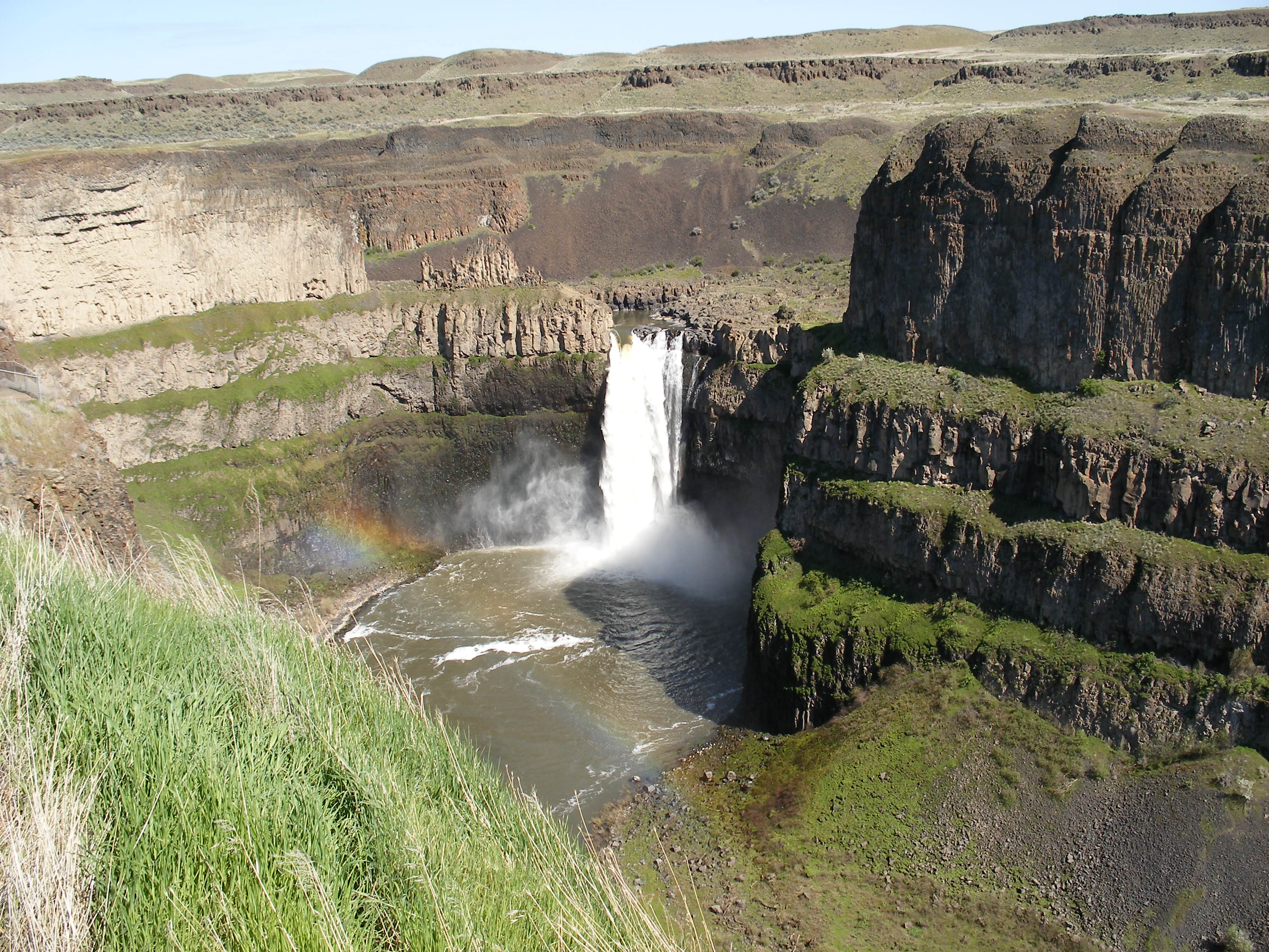
Der Palouse Falls State Park ist ein State Park im US-Bundesstaat Washington. Der 42 Hektar große Park liegt 37 km südöstlich von Washtucna im Franklin County im Südosten des Bundesstaats. Seinen Namen erhielt der Park durch seine Hauptattraktion, die 60 m hohen Palouse Falls.
Inhaltsverzeichnis
Geographie
Der Palouse River fließt innerhalb des Parks durch einen von den eiszeitlichen Missoula-Fluten vor 13.000 bis 15.000 Jahren erodierten Canyon und stürzt dabei über eine Klippe in ein rundes Becken.[1] Die turmhohen Wände des Canyons bestehen aus bis zu 30 m dicken Schichten aus Columbia-Plateaubasalt. Wenn im Frühjahr und im Frühsommer der Palouse River seinen Höchstwasserstand erreicht, ist der Wasserfall am beeindruckendsten.
Fauna
In den steilen Canyonwänden leben Gelbbauchmurmeltiere, Bullennattern und Klapperschlangen.[2]
Geschichte
Als erste Weiße berichtete die United States Exploring Expedition von dem Wasserfall, die ihn 1841 entdeckt hat. Die Palouse-Indianer nannten den Fall Aput Aput, was mit „Fallendes Wasser“ übersetzt wird. Das Land für den Park wurde von mehreren Firmen und Privatpersonen gestiftet,[3] der Park selbst wurde am 3. Juni 1951 gegründet. Um an den Indianerstamm der Palouse zu erinnern, wurde der Fall umbenannt.
Nach einer Legende der Palouse Indianer floß der Palouse River einst sanft in den Snake River. Aber vier Riesen, die Brüder waren, verfolgten ein mythisches, Big Beaver genanntes Wesen und trafen es fünf mal mit Speeren. Jedes mal, wenn das Wesen verwundet wurde, zerfurchte es die Erde. Als es zum fünften Mal getroffen wurde, verteidigte es sich tapfer und bohrte dabei einen tiefen Canyon, in den der Fluss über die Palouse Falls stürzt. Die zerklüfteten Wände des Canyons zeigen noch die tiefen Abdrücke der Klauen des Big Beavers.[4]
Touristische Einrichtungen
Der Park verfügt über einen Zeltplatz mit zehn Stellplätzen, über eine Beobachtungsplattform mit Blick auf den Wasserfall und über Picknickplätze.
Literatur
- Marge Mueller, Ted Mueller: Washington State Parks : a complete Recreation Guide. Seattle: Mountaineers Books 2004, ISBN 0-89886-642-1
Weblinks
- Internetpräsenz des State Park
- Palouse Falls State Park im Geographic Names Information System des United States Geological Survey
Einzelnachweise
- ↑ USGS: Glacial Lake Missoula and the Missoula Floods. Abgerufen am 30. September 2011.
- ↑ WTA: Palouse Falls. Abgerufen am 30. September 2011.
- ↑ Washington State Parks: Palouse Falls State Park, pdf-Datei. Abgerufen am 30. September 2011.
- ↑ Clark, Ella E.: Indian Legends of the Pacific Northwest. University of California Press, Berkeley, CA, 2003, ISBN 978-0-520-23926-5, S. 117 f
46.6634793-118.2235769Koordinaten: 46° 39′ 49″ N, 118° 13′ 25″ W
Wikimedia Foundation.