Round Island (Mackinac County)
- Round Island (Mackinac County)
-
Vorlage:Infobox Insel/Wartung/Höhe fehlt
| Round Island |
|
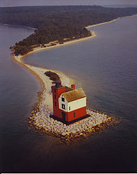
Leuchtturm auf der Nordwestspitze von Round Island |
| Gewässer |
Huronsee |
| Geographische Lage |
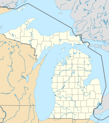
45° 49′ 47″ N, 84° 36′ 5″ W45.829722222222-84.601388888889Koordinaten: 45° 49′ 47″ N, 84° 36′ 5″ W |
|
|
| Fläche |
1,53 km² |
| Einwohner |
(unbewohnt) |
Round Island ist eine unbewohnte Insel im Huronsee im Mackinac County im US-Bundesstaat Michigan in den Vereinigten Staaten. Sie liegt in der Mackinacstraße, der Wasserstraße die den Michigansee und den Huronsee miteinander verbindet. Round Island liegt vor dem Hafen von Mackinac Island und die ca. 900.000 mit der Fähre anreisenden Mackinac-Island-Touristen fahren nah an der Insel vorbei. Im Südosten grenzt Round Island an die bewohnte Insel Bois Blanc. Die Strände der Insel sind generell steinig. Die Indianer Nordamerikas nennen die Insel „Nissawinagong“.
Fast die gesamten 153 ha der Inselfläche bilden die Round Island Wilderness Area, einem Teil des Hiawatha National Forest. Round Island ist nominell Teil der Stadt Mackinac Island, wird aber praktisch vom United States Forest Service betreut.
Das einzige Gebäude auf der Insel ist ein alter Leuchtturm, der Round Island Light. Der Schifffahrtskanal zwischen Mackinac Island und Round Island, der vom Leuchtturm beleuchtet wird, wird Round Island Channel genannt.
Im 1980er Film „Ein tödlicher Traum“ (Somewhere in Time) wurden Szenen mit Christopher Reeve und Jane Seymour nahe dem Leuchtturm gedreht. Der Leuchtturm ist für Besucher gesperrt.
Weblinks
Wikimedia Foundation.
Schlagen Sie auch in anderen Wörterbüchern nach:
Round Island — (zu deutsch: Rundinsel oder runde Insel ) ist der Name mehrerer Inseln in den Vereinigten Staaten von Amerika (USA) im US Bundesstaat Alabama: Round Island (Clarke County) Round Island (Mobile County) im US Bundesstaat Alaska: Round Island… … Deutsch Wikipedia
Round Island (Michigan) — Round Island … Wikipedia
Round Island Light (Michigan) — Round Island Light Location Mackinac County, Michigan Coordinates … Wikipedia
Mackinac County, Michigan — Infobox U.S. County county = Mackinac County state = Michigan map size = 200 founded = October 26, 1818 [http://www.mackinaccounty.net/comminfo9548159.asp] seat = St. Ignace area total sq mi = 2101 area land sq mi =1022 area water sq mi =1079… … Wikipedia
National Register of Historic Places listings in Mackinac County, Michigan — The following is a list of Registered Historic Places in Mackinac County, Michigan. This National Park Service list is complete through NPS recent listings posted November 10, 2011.[1] … Wikipedia
Beaver Island (Charlevoix County, Michigan) — Vorlage:Infobox Insel/Wartung/Höhe fehlt Beaver Island Die Iron Ore Bay am Südende von Beaver Island Gewässer … Deutsch Wikipedia
Mackinac Island — Infobox Islands name = Mackinac image caption = locator location map|Michigan|label=Mackinac Island|mark=Green pog.svg|lat dir=N|lat deg=45|lat min=51|lat sec=40|lon dir=W|lon deg=84|lon min=37|lon sec=50 map custom = yes native name =… … Wikipedia
Mackinac Island, Michigan — Infobox Settlement official name = Mackinac Island, Michigan other name = native name = nickname = motto = imagesize = 250px image caption = Grand Hotel flag size = image seal size = image shield = shield size = image blank emblem = blank emblem… … Wikipedia
Mackinac Island — Île Mackinac « Mackinac Island » redirige ici. Pour les autres significations, voir Mackinac Island (Michigan). Île Mackinac Mackinac Island … Wikipédia en Français
Ile Mackinac — Île Mackinac « Mackinac Island » redirige ici. Pour les autres significations, voir Mackinac Island (Michigan). Île Mackinac Mackinac Island … Wikipédia en Français


