Russia Dock Woodland

Russia Dock Woodland
Russia Dock Woodland (Greater London)
Russia Dock Woodland
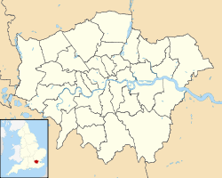
Lage des Russia Dock Woodlands in Greater London
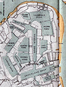
Plan der Surrey Commercial Docks (1921). Das Russia Dock ist in der Mitte zu sehen, das Stave Dock nordwestlich anschließend.
Stave Hill und die Treppen zur Aussichtsplattform (Mai 2008)

Das Russia Dock Woodland ist ein schmaler Park in Rotherhithe (London), der durch das Verfüllen des ‘’’Russia Docks’’’, eines historischen Hafenbeckens der Surrey Commercial Docks entstand. Das Russia Dock diente ursprünglich als Liegeplatz für Schiffe aus Norwegen, Russland und Schweden, die Holz nach London brachten. Das Weichholz, das „Deal Wood“ genannt wurde, benutzte man hauptsächlich zur Herstellung von Druckpapier und Möbeln.

Nach Schließung der Hafenbecken in den 1970er-Jahren wurde das Gelände von der London Docklands Development Corporation (LDDC) umgestaltet. Das Russia Dock wurde verfüllt (mit Ausnahme eines dünnen Rinnsals durch die Waldpflanzung) und 1980 zu einer 140.000 m² großen Waldpflanzung aufgeforstet. Man kann dort immer noch einige überlebende Details des Hafenbeckens finden, so z.B. Firststeine der Mauern, Wasserstandsanzeiger, Poller, Ankerketten und Treidelpfade. 1985 legte die LDDC einen künstlichen Hügel, den Stave Hill am Westrand des Parks (anstelle des historischen Stave Docks) an, der aus dem Aushub des Albion Channel (anstelle des historischen Albion Docks) besteht. Auf der Spitze des Hügels ist eine Reliefkarte in Bronzeguss von Michael Rizzello angebracht, die die früheren Hafenbecken zeigt.

Weblinks


Wikimedia Foundation.

Игры ⚽ Нужен реферат?

Schlagen Sie auch in anderen Wörterbüchern nach:

  • Russia Dock Woodland — is a long narrow park in Rotherhithe, London, created by the infilling of one of the former Surrey Commercial Docks. The former Russia Dock was originally used for the importing of timber from Norway, Russia and Sweden. The soft wood, known as… …   Wikipedia

  • Rotherhithe — Coordinates: 51°29′56″N 0°02′33″W / 51.4989°N 0.0426°W / 51.4989; 0.0426 …   Wikipedia

  • Stave Hill — is in a 5.2 acre ecological park, adjacent to Russia Dock Woodland, in the area of Rotherhithe, London Borough of Southwark close to Canada Water. Much of the park is what used to be the Stave Dock of the Surrey Commercial Docks, which was filled …   Wikipedia

  • Canada Water — …   Deutsch Wikipedia

  • London Borough of Southwark —   London borough   Coat of arms …   Wikipedia

  • Surrey Commercial Docks — The Surrey Commercial Docks were a large group of docks in Rotherhithe on the south bank (the Surrey side) of the Thames in South East London. The docks operated in one form or another from 1696 to 1969. Most were subsequently filled in and… …   Wikipedia

  • Oxleas Wood — is one of the few remaining areas of ancient deciduous forest in the London Borough of Greenwich in southeast London, dating back over 8,000 years. It is part of a larger continuous area of woodland and parkland on the south side of Shooter s… …   Wikipedia

  • Mitcham Common — Coordinates: 51°23′37″N 0°8′49″W / 51.39361°N 0.14694°W / 51.39361; 0.14694 …   Wikipedia

  • Mudchute — shown on a map of Greater London …   Wikipedia

  • Coldfall Wood — is an ancient wood in Muswell Hill, North London. It covers an area of approximately 14 hectares and is surrounded by the St. Pancras and Islington Cemetery, the East Finchley public allotments, and the residential roads Creighton Avenue and… …   Wikipedia

Share the article and excerpts

Direct link
Do a right-click on the link above
and select “Copy Link”