San Rafael Mountains

San Rafael Mountains

p1p5

San Rafael Mountains
San rafael mountains.jpg
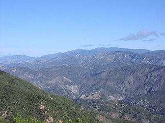
Höchster Gipfel Big Pine Mountain (2.079 m)
Lage Kalifornien (USA)
Teil der Transverse Ranges
San Rafael Mountains (Kalifornien)
San Rafael Mountains
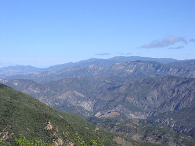
Koordinaten 34° 43′ N, 119° 44′ W34.710805555556-119.730970833332079Koordinaten: 34° 43′ N, 119° 44′ W

Die San Rafael Mountains sind ein Gebirgszug im Santa Barbara County in Kalifornien in den Vereinigten Staaten. Sie sind ein Teil der Transverse Ranges, die wiederum Bestandteil der Pacific Coast Ranges sind.

Der höchste Berg der Kette ist der Big Pine Mountain mit einer Höhe von 2.079 Metern, gefolgt vom San Rafael Mountain mit 2.010 Metern und dem McKinley Mountain mit 1.896 Metern.

Der größte Teil der Bergkette liegt im Los Padres National Forest, die nördlichen Abhänge gehören zum abgelegenen Naturschutzgebiet San Rafael National Wilderness Area.[1] Die Berge sind steil und zerklüftet. Die unteren Abhänge sind mit undurchdringlichem Chaparall bedeckt. In den höhergelegenen Gebieten wachsen Koniferen.[2] Auf den Berggipfeln ist oberhalb von 1.800 Metern im Winter mit Schneefällen zu rechnen, ansonsten herrscht in den San Rafael Mountains ein mediterranes Klima mit warmen, trockenen Sommern und milden, regnerischen Wintern.

Im Südwesten der Bergkette liegt der Zaca Lake, der einzige natürliche See im Santa Barbara County.[3]

Die San Rafael Mountains wurden erstmalig von Indianern vom Stamme der Chumash besiedelt. Von ihren Gebräuchen zeugt die Felsmalerei in abgelegenen Gebieten der Bergkette.[4] In früheren Jahrhunderten wurde im südlichen Teil der Bergkette Quecksilber abgebaut.[5] Aufgrund der inzwischen bekannten Gesundheitsgefahren des giftigen Schwermetalls versuchen Umweltschützer gegenwärtig zu ergründen, ob eine Sanierung erforderlich und machbar ist.

Einzelnachweise

  1. San Rafael National Wilderness Area auf www.wilderness.net (Zugriff am 2. Dezember 2009)
  2. Conservation Element. Santa Barbara County Comprehensive General Plan. Plants S. 114ff. (pdf-Dokument, Zugriff am 2. Dezember 2009)
  3. Open Space Element. Santa Barbara County Comprehensive General Plan, S. 71 (pdf-Dokument, Zugriff am 2. Dezember 2009)
  4. Conservation Element. Santa Barbara County Comprehensive General Plan. Archaeological Sites S. 227ff. (pdf-Dokument, Zugriff am 2. Dezember 2009)
  5. Conservation Element. Santa Barbara County Comprehensive General Plan. Mineral Resources S. 157ff. (pdf-Dokument, Zugriff am 2. Dezember 2009)

Weblinks


Wikimedia Foundation.

Игры ⚽ Поможем написать курсовую

Schlagen Sie auch in anderen Wörterbüchern nach:

  • San Rafael Mountains — The San Rafael Mountains are a mountain range in central Santa Barbara County, California, USA. They are a portion of the Transverse Ranges, which are themselves part of the Pacific Coast Ranges of western North America.The mountains mainly… …   Wikipedia

  • San Rafael Mountains — Sp Sán Rafaèlio kalna Ap San Rafael Mountains L Pakrantės klng. dalis, JAV (Kalifornija) …   Pasaulio vietovardžiai. Internetinė duomenų bazė

  • San Rafael Mountains — ▪ mountains, California, United States       segment of the Coast Ranges (see Pacific mountain system), southwestern California, U.S. The range extends southeastward for about 50 miles (80 km) from the Cuyama River to near the Santa… …   Universalium

  • San Emigdio Mountains — Geobox|Range name=San Emigdio Mountains image caption=Mt. Pinos pictured on the top right country=United States state=California region type = Counties region=Kern region1=Ventura region2=Los Angeles parent=Transverse Ranges border=Tehachapi… …   Wikipedia

  • San Rafael — (the Spanish language name of the Archangel Raphael) is a common place name in areas where that tongue is or was spoken:Towns, cities, municipalities, etc.*Argentina **San Rafael, Mendoza **San Rafael Department *Chile **San Rafael, Chile… …   Wikipedia

  • San Rafael Wilderness — Infobox protected area | name = San Rafael Wilderness iucn category = Ib caption = locator x = 16 locator y = 100 location = California, USA nearest city = Santa Barbara, California lat degrees = 34 lat minutes = 48 lat seconds = 41 lat direction …   Wikipedia

  • San Rafael, Lempira — San Rafael is a municipality in the Honduran department of Lempira.San Rafael,is one of the furthest municipalities of the Lempira department of Honduras.The best way to get to the municipality capital is via Santa Bárbara department, passing by… …   Wikipedia

  • San Rafael Pie de La Cuesta — is a municipality in the San Marcos department of Guatemala.A small town with red tiled roofs and abundant flowering trees in the northern department of San Marcos, Guatemala, a department which borders Mexico. Although part of San Marcos is cold …   Wikipedia

  • Laguna San Rafael National Park — Infobox Protected area | name = Laguna San Rafael National Park iucn category = II caption = Northern Patagonian Ice Field locator x = locator y = location = Aisén Region, Chile nearest city = Puerto Chacabuco lat degrees = 46 lat minutes = 40… …   Wikipedia

  • San Rafaelio kalnai — Sp Sán Rafaèlio kalna Ap San Rafael Mountains L Pakrantės klng. dalis, JAV (Kalifornija) …   Pasaulio vietovardžiai. Internetinė duomenų bazė

Share the article and excerpts

Direct link
Do a right-click on the link above
and select “Copy Link”