Sealion Island

Sealion Island
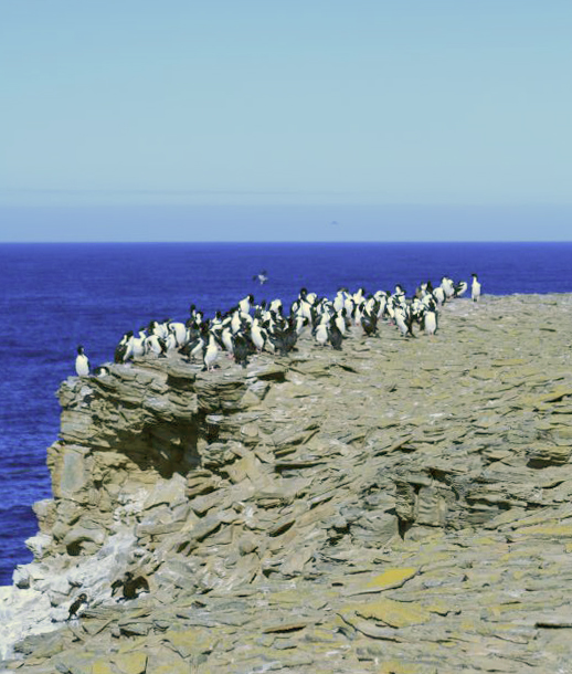
Sea Lion Island
Blauaugenscharben auf einem Riff
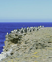
Gewässer Südatlantik
Inselgruppe Sea Lion Islands, Falklandinseln
Geographische Lage 52° 26′ 0″ S, 59° 5′ 0″ W-52.433333333333-59.08333333333346Koordinaten: 52° 26′ 0″ S, 59° 5′ 0″ W
Sea Lion Island (Falklandinseln)
Sea Lion Island
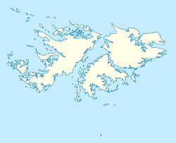
Länge 7,8 km
Breite 2,3 km
Fläche 9,05 km²
Höchste Erhebung Bull Hill
46 m
Hauptort Sea Lion Island Settlement

Sea Lion Island (span.: Isla de los Leones Marinos) ist die größte Insel der Sea-Lion-Inselgruppe der Falklandinseln. Die 9 km² große Insel ist etwa 7,8 km lang und 2,3 km breit. Der höchste Punkt der Insel ist der Bull Hill, welcher 46 m über dem Meeresspiegel liegt.

Sea Lion Island ist die am südlichsten gelegene Insel der Falklandinseln, welche heute noch bewohnt ist. Im 19. Jhd. war die Insel ein Stützpunkt für die Pinguinjagd, später wurde auf dem Eiland eine Schaffarm errichtet. Seit 1986 gibt es auf Sea Lion Island eine Station zur Beobachtung der Fauna und Flora der Sea Lion Inselgruppe, die außerdem von Touristen als Quartier genutzt werden kann. Die hauptsächlich aus Lutit und Sandstein bestehende Insel ist ein Gebiet der Ramsar-Konvention. Seelöwen, Orcas, Pinguine und ortsspezifische Arten wie der Falklandkarakara oder Subantarktikskua sind hier heimisch.


Wikimedia Foundation.

Игры ⚽ Поможем написать курсовую

Schlagen Sie auch in anderen Wörterbüchern nach:

  • Speedwell Island — Infobox Falkland island MapCaption= latitude= 52.2203 longitude= 59.4344 coordinates= coord|52|13|13|S|59|44|04|W|display=inline,title island group= english name= Speedwell Island former name=Eagle Island spanish name= Isla Águila meaning of name …   Wikipedia

  • USS Sealion (SS-315) — USS Sealion (SS/SSP/ASSP/APSS/LPSS 315), a Balao class submarine, was the second ship of the United States Navy to be named for the sea lion, any of several large, eared seals native to the Pacific. She is sometimes referred to as Sealion II ,… …   Wikipedia

  • HMS Sealion (1934) — HMS Sealion (N72) Allgemeine Daten Schiffstyp: U Boot …   Deutsch Wikipedia

  • HMS Sealion (72S) — HMS Sealion (N72) Allgemeine Daten Schiffstyp: U Boot …   Deutsch Wikipedia

  • HMS Sealion (72 S) — HMS Sealion (N72) Allgemeine Daten Schiffstyp: U Boot …   Deutsch Wikipedia

  • HMS Sealion (N 72) — HMS Sealion (N72) Allgemeine Daten Schiffstyp: U Boot …   Deutsch Wikipedia

  • HMS Sealion (N72) — Allgemeine Daten Schiffstyp: U Boot Schiffsklasse …   Deutsch Wikipedia

  • Operation Sealion — Infobox Military Conflict conflict=Operation Sealion caption= partof=the Western Front of World War II place= Normandy, the Belgian coast line, the English Channel and the English coast line from Kent to Dorset, Isle of Wight and parts of Devon,… …   Wikipedia

  • HMS Sealion (72S) — HMS Sealion was a Royal Navy S class submarine which was launched March 16, 1934 and fought in World War II.She had an eventful career after the outbreak of war. She attacked U 21 off the Dogger Bank in November 1939, but failed to sink her. Her… …   Wikipedia

  • Weddell Island — Infobox Falkland island MapCaption= latitude= 51.8786 longitude= 61.0067 coordinates= coord|51|52|43|S|61|00|24|W|display=inline,title island group= english name=Weddell Island former name=Swan Island spanish name=Isla San José meaning of… …   Wikipedia

Share the article and excerpts

Direct link
Do a right-click on the link above
and select “Copy Link”