- Snækollur
-
Snækollur 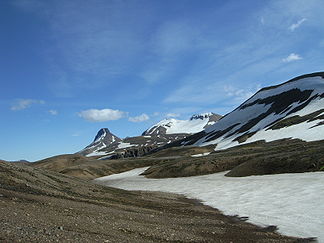
Gipfel der Kerlingarfjöll: Loðmundur links, Snækollur in der Mitte, Fannborg rechts
Höhe 1.482 m Lage Island Gebirge Kerlingarfjöll Geographische Lage 64° 38′ 36″ N, 19° 13′ 38″ W64.643333333333-19.2272222222221482Koordinaten: 64° 38′ 36″ N, 19° 13′ 38″ W 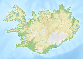

Typ Tafelvulkan Gestein Rhyolith Beim Snækollur handelt es sich um den mit 1482 Metern höchsten Berg des vulkanischen Gebirgszuges der Kerlingarfjöll in Island.
Inhaltsverzeichnis
Teil der Kerlingarfjöll
Die Kerlingarfjöll liegen im Hochland von Island einige Kilometer östlich der Kjölur-Piste.
Der Berg befindet sich in den östlichen Kerlingarfjöll, den sogenannten Austurfjöll, in der Mitte des Gebirgszuges östlich der Hveradalir.
Der Berg gehört zu einem erloschenen Zentralvulkan der in früheren Zeiten den Namen Háinúper trug. Daher besteht der Berg aus Rhyolithgestein. Auf ihm liegt ein kleiner Gletscher.[1]
Name
Er hat eine mehr oder minder keilförmige Gestalt und ist fast das ganze Jahr über mit Schnee bzw. Eis bedeckt, daher auch sein isländischer Name, der übersetzt Schneekopf bedeutet.
Sport
Bergwandern
Man benötigt etwa drei Stunden für den Aufstieg von den Hütten im Árskarð, allerdings ist der Aufstieg sehr viel kürzer vom Skigebiet am Fuß des Berges (beim Hochtemperaturgebiet Hveradalir). Vom Gipfel des Berges hat man eine hervorragende Aussicht über einen Großteil des Hochlandes von Island und bis in die Westfjorde.[2]
Der benachbarte spitze Gipfel des Loðmundur (1429 m) ist ebenfalls ein beliebtes Ziel von Bergsteigern[3].
Sommerskigebiet
Am Árskarð errichtete der Ferðafélag Íslands 1937-38 eine Hütte und zu Anfang der 1960er Jahre wurden dort auch einige weitere Gebäude für die Skischule errichtet. Diese bestand bis 1989 am Hang des Snækollur.
Die Klimaveränderungen haben das ehemalige Sommerskigebiet als solches unrentabel gemacht.
Einzelnachweise
- ↑ Ari Trausti Guðmundsson, Pétur Þorleifsson: Íslensk fjöll. Gönguleiðir á 151 tind. Reykjavík 2004, S. 252
- ↑ Íslandshandbókin, 2. bindi, Reykjavik, Örn og Örlygur, 1989, bls. 888
- ↑ Ari Trausti, ebd., S. 196 f.
Siehe auch
Weblinks
Kategorien:- Eintausender
- Lavadom
- Berg in Island
- Berg in Europa


Wikimedia Foundation.