Sunburst Lake

Sunburst Lake
Sunburst Lake
Sunburst Lake mit Ranger-Hütte
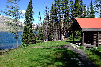
Geographische Lage Mount Assiniboine Provincial Park, British Columbia, Kanada
Abfluss über Cerulean Lake und zum Kootenay River
Daten
Koordinaten 50° 55′ 0″ N, 115° 39′ 0″ W50.916667-115.652250Koordinaten: 50° 55′ 0″ N, 115° 39′ 0″ W
Sunburst Lake (British Columbia)
Sunburst Lake
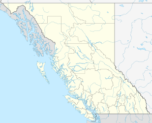
Höhe über Meeresspiegel 2.250 m
Maximale Tiefe 9 mf10

Der kleine, neun Meter tiefe Sunburst Lake liegt im Mount Assiniboine Provincial Park in British Columbia auf einer Höhe von 2.250 Metern. Der See liegt westlich der Assiniboine Lodge und nördlich des Lake Magog-Campingplatz. Er ist ein beliebtes Ziel für Tagesausflüge von der Lodge oder dem Campingplatz aus.

Im See leben Regenbogenforellen (Oncorhynchus mykiss) und wahrscheinlich auch die seltene Cutthroat-Forelle (Oncorhynchus clarki). Im Sunburst Lake wurden außergewöhnlich große Exemplare mit 75 cm Länge gefangen.

1928 bauten die Brewster Brothers aus Seebe am Sunburst Lake eine Hütte. Die Sunburst Cabin wurde von Pat Brewster betrieben, bis sie diese 1949/50 an Elizabeth Rummel verkaufte. Nach der Pensionierung von Elizabeth „Lizzie“ Rummel 1970 wurde das Sunburst Camp zu einem Jugendcamp umfunktioniert und schlussendlich von BC Parks übernommen. Heute dient die Hütte als Unterkunft für Ranger.


Wikimedia Foundation.

Игры ⚽ Поможем написать курсовую

Schlagen Sie auch in anderen Wörterbüchern nach:

  • Sunburst Lake National Wildlife Refuge — Sp Sánbersto ẽžero nacionãlinis gamtõs rezervãtas Ap Sunburst Lake National Wildlife Refuge L JAV (Š. Dakota) …   Pasaulio vietovardžiai. Internetinė duomenų bazė

  • Elizabeth Lake — mit Sunburst Valley Geographische Lage British Columbia (Kanada) Abfluss …   Deutsch Wikipedia

  • Chase Lake Wilderness — IUCN Category Ib (Wilderness Area) …   Wikipedia

  • Chase Lake National Wildlife Refuge — IUCN Category IV (Habitat/Species Management Area) …   Wikipedia

  • Devils Lake State Parks (North Dakota) — Devils Lake State Park is the name applied to the two state parks located in Ramsey County, North Dakota located on Devils Lake to the south of Devils Lake, North Dakota. The park consists of one park, Grahams Island, and one recreation area,… …   Wikipedia

  • Cottonwood Lake National Wildlife Refuge — is a National Wildlife Refuge in McHenry County, North Dakota. It is managed under J. Clark Salyer National Wildlife Refuge. References Refuge directory listing  This article incorporates public domain material from websites or documents of… …   Wikipedia

  • Dakota Lake National Wildlife Refuge — is a National Wildlife Refuge in North Dakota. It is managed under Kulm Wetland Management District. Dakota Lake National Wildlife Refuge was established by Executive Order 8117, signed on May 10, 1939 by President Franklin D. Roosevelt. The… …   Wikipedia

  • Devils Lake Wetland Management District — is located in the heart of the Prairie Pothole Region of the United States. The District was established in 1962 to purchase and protect wetland habitat for migratory waterfowl and other wildlife in northeastern North Dakota. One of the primary… …   Wikipedia

  • Cerulean Lake — Geographische Lage Mount Assiniboine Provincial Park, British Columbia (Kanada) Zuflüsse vom …   Deutsch Wikipedia

  • Mount Assiniboine Provincial Park — IUCN Kategorie II …   Deutsch Wikipedia

Share the article and excerpts

Direct link
Do a right-click on the link above
and select “Copy Link”