Sylan

Sylan

p1p5

Sylan
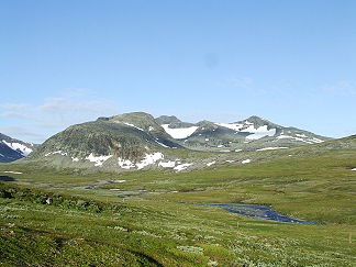
Sylarna.JPG
Höchster Gipfel Storsylen (1.762 moh.)
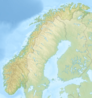
Lage Sør-Trøndelag (Norwegen), Jämtlands län (Schweden)
Sylan (Norwegen)
Sylan
Koordinaten 63° 1′ N, 12° 11′ O63.01666666666712.1833333333331762Koordinaten: 63° 1′ N, 12° 11′ O

Sylan, Sylane oder Sylene (Norwegisch), Sylarna (Schwedisch), Bealjehkh (Südsamisch), (auf deutsch Die Dornen), ist ein Gebirge an der Grenze zwischen Norwegen und Schweden, in den Provinzen Sør-Trøndelag und Jämtlands län.

Der zentral gelegene Gebirgskamm erstreckt sich vom Lillsylen im Norden über den höchsten Berg, Storsylen (1762 m), bis nach Süden zum Storsola (1728 m). Der Gebirgskamm ist auch eine beliebte Wanderstrecke für geübte Wanderer.

Es gibt mehrere Berghütten in der Umgebung. Der Norwegische Bergwanderverein unterhält die Hütten Schultzhytta i Roltdalen, Storerikvollen und Nedalshytta av Nesjøen. Auf der schwedischen Seite gibt es die Hütten Blåhammarens Fjällstation, Sylarnas Fjällstation und Fjällstuga Helags.

Weblinks

 Commons: Sylan – Sammlung von Bildern, Videos und Audiodateien

Wikimedia Foundation.

Игры ⚽ Поможем написать реферат

Schlagen Sie auch in anderen Wörterbüchern nach:

  • Sylan — Sylan …   Wikipedia Español

  • Sylan — Geobox|Range name = Sylan native name = other name = Sylarna | other name1 = Sylene | other name2 = Sylane | other name3 = Bealjehkh category = etymology = country = Norway | country1 = Sweden state = region = Sør Trøndelag | region1 = Jämtland… …   Wikipedia

  • sylančius — ×sylañčius sm. (2) žr. sylinčius: Ans turėjo sylos, buvo sylañčius Vvr …   Dictionary of the Lithuanian Language

  • Geography of Jämtland — Jämtland is a large land locked Swedish province in the heart of the Scandinavian peninsula in northern Europe. Jämtland covers an area of 34 009 square kilometres, 8.3 per cent of Sweden s total area and is the second largest province in Sweden …   Wikipedia

  • Storsylen — Infobox Mountain Name = Storsylen Photo = StorsylenNorthernRidge.jpg Caption = Summit seen from the northern ridge, along main hiking route. Elevation = convert|1762|m|ft|0|lk=on Location = Tydal, Sør Trøndelag, NOR Range = Sylan Prominence =… …   Wikipedia

  • Ljungan — Verlauf des Ljungan DatenVorlage:Infobox Fluss/GKZ fehlt …   Deutsch Wikipedia

  • Nesjøen — Location Tydal, Sør Trøndelag Coordinates 62°58′47″N 12°00′28″E …   Wikipedia

  • Skarvan og Roltdalen-Nationalpark — Skarvan og Roltdalen Nationalpark …   Deutsch Wikipedia

  • Storsylen — Nordansicht Höhe 1.762  …   Deutsch Wikipedia

  • Storsylen — Le sommet vu depuis le nord Géographie Altitude 1 762 m Massif Sylan (Alpes scandinaves) …   Wikipédia en Français

Share the article and excerpts

Direct link
Do a right-click on the link above
and select “Copy Link”