Waimangaroa River

Waimangaroa River
Waimangaroa RiverVorlage:Infobox Fluss/GKZ_fehlt
Lage Neuseeland
Flusssystem Waimangaroa River
Quelle Im Happy Valley östlich der Stockton Mine
41° 42′ 12,4″ S, 171° 53′ 24,6″ O-41.70344171.890176700
Quellhöhe 700 mVorlage:Infobox Fluss/NACHWEISE_fehlen
Mündung In die Tasmansee
-41.697949171.7460610

41° 41′ 53″ S, 171° 44′ 46″ O-41.697949171.7460610
Mündungshöhe mVorlage:Infobox Fluss/NACHWEISE_fehlen
Höhenunterschied 700 mVorlage:Infobox Fluss/LÄNGE_fehltVorlage:Infobox Fluss/EINZUGSGEBIET_fehlt

Vorlage:Infobox Fluss/ABFLUSS_fehltVorlage:Infobox Fluss/BILD_fehlt

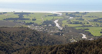
Der Waimangaroa River mündet bei Waimangaroa ins Meer, Ausblick von der Denniston road

Der Waimangaroa River ist ein Fluss im Buller-Distrikt in der Region West Coast auf der Neuseeländischen Südinsel.

Er entspringt in dem so genannten Happy Valley östlich der umfangreichen Flächen des Tagebaugebietes des Kohlenbergwerks Stockton Mine und einen Kilometer südlich eines nicht zum Flusssystem gehörenden, nach Norden entwässernden Stausees. Der Oberlauf im Happy Valley trägt auch den Namen Cypress Stream. Er fließt zunächst in südliche Richtung durch die Mittelgebirgslandschaft des Mount William Range.

Dabei nimmt er mehrere Nebengewässer auf, darunter den Whirlwind Stream, Herbert Stream, Webb Stream, Ernest Stream, L75 Stream, Wilson Creek und den Cedar Creek. Bei einer aufgegebenen Mine nahe dem Cedar Creek Saddle ändert er seinen Lauf in Richtung Nordwesten und fließt nördlich an den Bergbausiedlungen Burnetts Face und Denniston vorbei. Nebenflüsse in diesem Bereich sind Deep Stream, Gomorrah Creek, Hut Stream, Burnett Stream und Conns Creek.

Im Unterlauf wird der Waimangaroa River bei der Ortschaft Waimangaroa von dem State Highway 67 und der Güterbahnstrecke Stillwater-Westport-Line überbrückt, nimmt noch den Kiwi Creek auf und mündet kurz darauf in die Tasmansee.[1]

Einzelnachweise

  1. Blattschnitt NZTopo50-BR21 Granity der amtlichen Topographischen Karte Neuseelands 1:50.000, Edition 1, 2009, Onlineversion

Wikimedia Foundation.

Игры ⚽ Нужно сделать НИР?

Schlagen Sie auch in anderen Wörterbüchern nach:

  • Waimangaroa River — The Waimangaroa River is located on the West Coast of New Zealand.The river passes through tussock, scrub and forested areas before draining into the Karamea Bight in the Tasman Sea. It passes through the town of Waimangaroa and is crossed by the …   Wikipedia

  • Waimangaroa — Infobox Settlement name = Waimangaroa subdivision type = Country subdivision name = New Zealand subdivision type1= Region subdivision name1= West Coast subdivision type2= District subdivision name2= Buller District pushpin pushpin label position …   Wikipedia

  • Seddonville Branch — The Seddonville Branch, now truncated and operating as the Ngakawau Branch, is a branch line railway in the West Coast region of New Zealand s South Island. Construction of the line began in 1874 and it reached its final terminus at the Mokihinui …   Wikipedia

  • Conns Creek Branch — The Conns Creek Branch was a short branch line railway in the West Coast region of New Zealand s South Island. It diverged from the Seddonville Branch in Waimangaroa and followed the Waimangaroa River to its terminus at the foot of the Denniston… …   Wikipedia

  • List of rivers of New Zealand — This is a list of all waterways named as rivers in New Zealand. In a small number of cases, which have not been fully indexed here, there are multiple rivers bearing the same name; in these cases the notation (#) indicates the number of rivers… …   Wikipedia

  • Liste der Flüsse in Neuseeland — Die Liste der Flüsse in Neuseeland gibt eine Übersicht über alle permanent wasserführenden Flüsse im Staat Neuseeland: Inhaltsverzeichnis A B C D E F G H I J K L M N O P Q R S T U V W X Y Z …   Deutsch Wikipedia

  • Liste des cours d'eau de Nouvelle-Zélande — Liste des cours d eau de Nouvelle Zélande. Pour un petit nombre de cas, qui n a pas été pris intégralement en compte ici, il existe de multiples rivières portant un nom identique. Dans ce cas, la notation (#) indique le nombre de rivières… …   Wikipédia en Français

  • Liste des rivières de Nouvelle-Zélande — Liste des cours d eau de Nouvelle Zélande Liste des cours d eau de Nouvelle Zélande. Pour un petit nombre de cas, qui n a pas été pris intégralement en compte ici, il existe de multiples rivières portant un nom identique. Dans ce cas, la notation …   Wikipédia en Français

  • Happy Valley, New Zealand — Happy Valley is the name of four locations in New Zealand.Happy Valley, South AucklandThis rural locality is approximately 20 km south east of Papakura.Happy Valley, WellingtonHappy Valley is a suburb of the city is Wellington and is the south… …   Wikipedia

  • Rivers of New Zealand — The Inangahua River in the South Island photographed in 1977. The rivers of New Zealand are used for a variety of purposes and face a number of environmental issues. Many of the rivers in the South Island are braided rivers. Contents …   Wikipedia

Share the article and excerpts

Direct link
Do a right-click on the link above
and select “Copy Link”