- Wairoa River (Northland)
-
Wairoa River 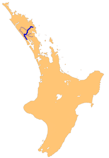
Das Manganui-Wairoa-Wairua Fluss-System in Northland
Daten Lage Region Northland, Nordinsel (Neuseeland) Flusssystem Wairoa River Abfluss über Kaipara Harbour → Tasmansee Ursprung Zusammenfluss von Manganui und Wairua River nordöstlich Dargaville
35° 54′ 19″ S, 173° 57′ 5″ O-35.905195173.951411Mündung nahe Ruawai in den Kaipara Harbour -36.184553174.058342Koordinaten: 36° 11′ 4″ S, 174° 3′ 30″ O
36° 11′ 4″ S, 174° 3′ 30″ O-36.184553174.058342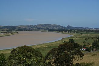
Wairoa River bei Dargaville
Der Wairoa ist ein Fluss durch den nördlichen Teil der North Auckland Peninsula auf Neuseelands Nordinsel.
Neben ihm gibt es noch weitere Flüsse mit diesem Namen in Neuseeland, da in der Sprache der Maori Wairoa der Begriff für langes Wasser ist. Mit über 150 km Länge ist er Neuseelands längster Wairoa und der längste Fluss der Region Northland. Der Fluss wird stellenweise auch als der Nördliche Wairoa River bezeichnet.
Im Oberlauf des Flusses wird er durch zwei separate Flussläufe geprägt, den Manganui River und zur völligen Verwirrung den Wairua River. Diese zwei Flussläufe vereinigen sich nordöstlich von Dargaville und werden hier zum Wairoa River. Von hier verläuft der Flusslauf zuerst südwestlich bis Dargaville, dann südöstlich über rund 40 Kilometer bis zum nördlichen Ausläufer des Kaipara Harbour. Ab Dargaville entsteht durch den Fluss, da keine weitere feste Flussquerung besteht, die Pouto Peninsula, die die nördliche Abgrenzung des Kaipara Harbour von der Tasmansee bildet.
Weblinks
 Commons: Wairoa River, Northland – Sammlung von Bildern, Videos und AudiodateienKategorien:
- Fluss in Neuseeland
- Northland (Region)


Wikimedia Foundation.