- Washington State Route 106
-

Karte 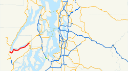
Basisdaten Gesamtlänge: 20,09 mi / 32,32 km Eröffnung: 1964 Anfangspunkt:  US 101 in Skokomish
Endpunkt:  WA 3 in Belfair
County: Mason County Washington State Route 106 (SR 106) ist eine 32 km lange State Route im Mason County. Er führt vom U.S. Highway 101 (US 101) in Skokomish zur Washington State Route 3 südlich von Belfair.[1] Der Highway wurde 1964 eingerichtet,[2] war aber zuvor ein Teil anderer Strecken des primären Straßennetzes des Bundesstaates.
Inhaltsverzeichnis
Streckenbeschreibung
State Route 106 beginnt an einer Straßengabelung am U.S. Highway 101 im Census-designated place (CDP) Skokomish, nördlich von Shelton. Von dieser Kreuzung führt die Straße nach Südosten, überbrückt den Skobob Creek und schlängelt dann am Ufer von Skokomish River und Annas Bay zur Ortschaft Union. Von dort aus verläuft die Strecke am südlichen Ufer des Hood Canals und am Twanoh State Park vorbei zur Kreuzung mit der Washington State Route 3 südlich von Belfair, wo sie endet. Der Streckenabschnitt vor der Kreuzung mit SR 3 bei Belfair wurde 2007 durchschnittlich von 6100 Fahrzeugen täglich genutzt.[3] Im Jahr 1970 befuhren denselben Streckenabschnitt im Tagesdurchschnitt 2000 Fahrzeuge.[4]
Geschichte
 Vor 1964 war die Trasse von SR 106 Bestandteil zweier anderer Straßen, PSH 14 (1937–1955) und PSH 21 (1955–1964).
Die erste vom Bundesstaat unterhaltene Straße auf der heutige Trasse war die 1915 durch die Washington State Legislature und das Department of Highways eingerichtete State Road 21, die von Skokomish nach Kingston führte.[5][6] State Road 21 wurde 1923 zur State Road 14 und erhielt den Namen Navy Yard Highway.[7] Als der Bundesstaat 1937 die Primary und Secondary Highways einrichtete, wurde State Road 14 zum Primary State Highway 14 (PSH 14).[8] Der Abschnitt Skokomish–Gorst wurde 1955 dem Primary State Highway 21 zugeschlagen.[9] Bei der Neunummerierung der Highways in Washington von 1964 wurde PSH 21 in SR 106,[2] SR 3 und SR 104 aufgeteilt.[10]
In den letzten Jahren hat das Washington State Department of Transportation (WSDOT) einige Verbesserungen an der Straße durchgeführt. 2005 ersetzte man am Skobob Creek den Düker durch eine Brücke; die Stelle liegt rund 1,4 km östlich von Skokomish.[1][11][12] Eine Verkehrsampel wurde 2007 an der Kreuzung von SR 106 / SR 3 südlich von Belfair installiert.[13]
Siehe auch
Einzelnachweise
- ↑ a b Washington State Department of Transportation (2006): State Highway Log: Planning Report, SR 2 to SR 971 (Englisch) (PDF). Abgerufen am 12. Juni 2009.
- ↑ a b Washington State Legislature (1970): RCW 47.17.185: State route No. 106 (Englisch). Abgerufen am 12. Juni 2009.
- ↑ Washington State Department of Transportation (2007): 2007 Annual Traffic Report (Englisch) (PDF). Abgerufen am 12. Juni 2009.
- ↑ Washington State Highway Commission, Department of Highways (1970): Annual Traffic Report, 1970 (Englisch). Washington State Department of Transportation. Abgerufen am 12. Juni 2009.
- ↑ State Roads Established By Legislature of 1915 (Englisch) (PDF). Washington State Department of Transportation (1915). Abgerufen am 12. Juni 2009.
- ↑ Washington State Legislature: Chapter 64: Classification of Highways. In: Session Laws of the State of Washington, 1915 (Englisch), Olympia, Washington: Washington State Legislature 19. März 1915 (Zugriff am 12. Juni 2009) „A secondary state highway is established as follows: State road No. 21: This road shall begin at Kingston, thence by the most feasible route through Port Gamble, Poulsbo and Bremerton to a connection with the Olympic Highway between Shelton and Hoodsport in Mason county“
- ↑ Washington State Legislature: Chapter 185: Primary and Secondary Highways. In: Session Laws of the State of Washington, 1923 (Englisch), Olympia, Washington: Washington State Legislature 19. März 1923 (Zugriff am 12. Juni 2009) „A primary state highway, to be known as State Road No. 14 or the Navy Yard Highway, is established as follows: Beginning at a junction with State Road No. 9, at the most feasible point between Shelton and Potlatch in Mason County; thence by the most feasible route through Union City and Clifton to Charleston in Kitsap County; also from a junction near Tidewater Creek in Kitsap County through Port Orchard, to Gig Harbor in Pierce County; also from a junction near Port Orchard by the most feasible route to the ferry landing at Harper.“
- ↑ Washington State Legislature: Chapter 190: Establishment of Primary State Highways. In: Session Laws of the State of Washington, 1937 (Englisch), Olympia, Washington: Washington State Legislature 18. März 1937 (Zugriff am 12. Juni 2009) „A primary state highway to be known as Primary State Highway No. 14, or the Navy Yard Highway, is hereby established according to description as follows: Beginning at a junction with Primary State Highway No. 9, in the vicinity north of Shelton, thence in a northeasterly direction by the most feasible route by way of Port Orchard, thence in a southerly direction by the most feasible route to Gig Harbor; also beginning in the vicinity of Port Orchard on Primary State Highway No. 14, as herein described, thence in an easterly direction by the most feasible route to the ferry landing at Harper.“
- ↑ Washington State Legislature: Chapter 83. In: Session Laws of the State of Washington, 1955 (Englisch), Olympia, Washington: Washington State Legislature 1955 (Zugriff am 12. Juni 2009)
- ↑ C. G. Prahl (1. Dezember 1965): Identification of State Highways (Englisch) (PDF). Washington State Highway Commission, Department of Highways. Abgerufen am 12. Juni 2009.
- ↑ Washington State Department of Transportation (2005): SR 106 - Skobob Creek Fish Passage - Complete December 2005. Abgerufen am 12. Juni 2009.
- ↑ SR 106, Skobob Creek Fish Passage Map (Englisch). Washington State Department of Transportation (2005). Abgerufen am 12. Juni 2009.
- ↑ Washington State Department of Transportation (2007): SR 3 - SR 106 South Belfair Signal - Complete July 2007 (Englisch). Abgerufen am 12. Juni 2009.
Weblinks
Kategorie:- Washington State Route


Wikimedia Foundation.