- Washington State Route 113
-
Karte 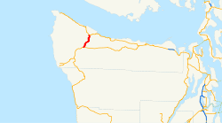
Basisdaten Gesamtlänge: 9,98 mi. / 16,06 km Anfangspunkt:  US 101 in Sappho
Endpunkt:  WA 112 bei Clallam Bay
County: Clallam County Washington State Route 113 (SR 113, allgemein Burnt Mountain Road) ist eine 16,06 km lange[1] State Route im Clallam County auf der Olympic Peninsula in Washington. Sie führt vom U.S. Highway 101 in Sappho südwärts zur Washington State Route 112 südöstlich von Clallam Bay. Die heutige Route bildete 1937–1955 den Secondary State Highway 9A. Dann erhielt SSH 9A den Verlauf entlang der heutigen Washington State Route 112. Die Strecke wurde 1991 zur SR 113, nachdem die frühere SR 113 bereits 1975 zur Washington State Route 20 wurde. Sie war zuvor eine Zweigstrecke des Primary State Highway 9 (PSH 9) nach Port Townsend und von 1937 bis 1964 ein Zweig des Secondary State Highways 1D.
Inhaltsverzeichnis
Streckenbeschreibung
State Route 113 (SR 113) beginnt an einer Kreuzung mit dem U.S. Highway 101 (US 101) in der Ortschaft Sappho, östlich von Lake Pleasant und nördlich des Sol Duc River. Von hier führt die Strecke nach Nordosten, wobei sie dreimal eine Eisenbahntrasse und zweimal den Beaver Creek kreuzt, bevor sie den Beaver Lake erreicht. Vom See aus führt die Straße nach Norden zur Washington State Route 112, an der sie südöstlich von Clallam Bay endet. Unweit der Kreuzung mit der US 101 verkehrten 2007 auf der SR 113 im Durchschnitt geschätzte 1000 Fahrzeuge täglich,[2] was ein Ruckgang im Vergleich zur Schätzung von 1500 Fahrzeugen pro Tag im Jahr 1992 bedeutete.[3]
Früherer Streckenverlauf (1964–1973)
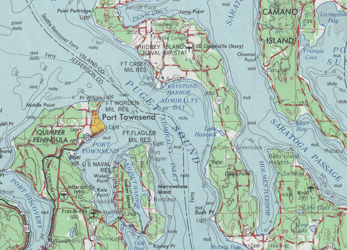
Der ursprüngliche Streckenverlauf der SR 113, der zwischen 1964 und 1973 gültig war,[4][5] hatte eine Länge von 16,29 Meilen (26,22 km). Die Strecke zweigte in Discovery Bay von der US 101 ab und führte zur damaligen Washington State Route 525 (heute SR 20) südlich von Coupeville.[6] 1973 wurde dieser Abschnitt bei der Verlängerung der SR 20 von Fredonia westwärts nach Discovery Bay diesem Highway zugeschlagen.[5] Die Strecke begann an der US 101 in Discovery Bay, südwestlich von Port Townsend im Jefferson County. Von dort folgte die Straße der Uferlinie der Discovery Bay, vorbei am Jefferson County International Airport und der Airport Cutoff Road (heute Washington State Route 19) hinein nach Port Townsend. Innerhalb der Stadt trug SR 113 den Namen Sims Way und Water Street, bevor sie über die Fähre von Port Townsend nach Keystone ins Island County führte.[7] Dort führte die Straße durch den Fort Casey State Park und durch Ebey's Landing National Historical Reserve, bevor sie nordwärts und ostwärts zu ihrem Ende an der SR 525 südlich von Coupeville führte. Im Jahr 1970 wurde die Straße an der Old Fort Townsend Road bei Port Townsend im Tagesdurchschnitt von etwa 3150 Fahrzeugen genutzt, womit sie dieser Abschnitt damals das am meisten befahrene Teilstück der früheren SR 113 war;[6] 2007 lag das verkehrsreichste Teilstück der State Route der Abschnitt an der Kreuzung mit der Airport Cutoff Road (SR 19), wo der durchschnittliche Verkehr auf 18.000 Fahrzeuge am Tag geschätzt wurde.[2]
Geschichte
Trasse Discovery Bay–Coupeville (1964–1973)
 Karte von 1966 mit der Streckenführung von Discovery Bay nach Coupeville, von 1964 bis 1973 als SR 113 gewidmet
Von 1964 bis 1973 verwendete SR 113 eine Trasse von Discovery Bay Coupeville, die 1937 ihren Ursprung als Zweig des Primary State Highway 9 (PSH 9 PT) nach Port Townsend und als Ast des Secondary State Highway 1D (SSH 1D) hatte, als ie Primary and Secondary Highways in Washington geschaffen wurden.[8] 1964 wurden diese beiden Landstraßen als SR 113 im neuen Nummerierungssystem des Bundesstaates zusammengeschlossen, das von der Washington State Legislature und dem Washington State Department of Transportation beschlossen wurde.[4] Als die Washington State Route 20 von Fredonia aus westwärts verlängert wurde,[5] wurde SR 113 aufgelassen.[9][10][11]
Die Fähre von Port Townsend nach Keystone war bis 1994 nicht Bestandteil der SR 20, doch dann wurden alle Verbindungen der Washington State Ferries in das bundesstaatliche Fernstraßennetz eingegliedert.[12][13]
Trasse Sappho–Clallam Bay (1991–heute)
Die heutige Trasse der SR 113 wurde erstmals 1937 vom Bundesstaat unterhalten, während der Einführung des primären und sekundären Straßensystems als SSH 9A, der von Sappho nach Port Angeles führte.[8][14] Das Segment Sappho–Clallam Bay wurde 1955 fallengelassen und SSH 9A stattdessen westwärts nach Neah Bay geführt.[15][16] SSH 9A wurde bei der Highway-Neunummerierung 1964 zur SR 112 und SR 113 wurde einer anderen Strecke zugewiesen.[4] Im Jahr 1991 erhielt SR 113 die heutige Streckenführung von Sappho nach Clallam Bay. Weitere Änderungen haben seitdem nicht stattgefunden.[17][18]
Belege
- ↑ Washington State Department of Transportation (2006): State Highway Log: Planning Report, SR 2 to SR 971 (Englisch). Abgerufen am 20. Juni 2009.
- ↑ a b Washington State Department of Transportation (2007): 2007 Annual Traffic Report (Englisch). Abgerufen am 20. Juni 2009.
- ↑ Washington State Department of Transportation (1992): 1992 Annual Traffic Report (Englisch). Abgerufen am 20. Juni 2009.
- ↑ a b c C. G. Prahl (1. Dezember 1965): Identification of State Highways (Englisch) (PDF). Washington State Highway Commission, Department of Highways. Abgerufen am 20. Juni 2009.
- ↑ a b c Washington State Legislature (1964): RCW 47.17.080: State route No. 20 (Englisch). Abgerufen am 20. Juni 2009.
- ↑ a b Washington State Highway Commission, Department of Highways (1970): Annual Traffic Report, 1970 (Englisch) (PDF). Washington State Department of Transportation. Abgerufen am 20. Juni 2009.
- ↑ Whidbey Island Route (Englisch). Washington State Ferries (2009). Abgerufen am 20. Juni 2009.
- ↑ a b Washington State Legislature: Chapter 190: Establishment of Primary State Highways; Chapter 207: Classification of Public Highways. In: Session Laws of the State of Washington, 1937 edition (Englisch), Olympia, Washington: Washington State Legislature 1937 (Zugriff am 20. Juni 2009) „SEC. 9. A primary state highway to be known as Primary State Highway No. 9, or the Olympic Highway, is hereby established according to description as follows: Beginning at Olympia on Primary State Highway No. 1, thence in a westerly direction by the most feasible route by way of Elma, Montesano and Aberdeen to Hoquiam, thence in a northwesterly direction by the most feasible route by way of Lake Quinault to Forks, thence in an easterly direction by the most feasible route by way of Port Angeles to the vicinity of Discovery Bay, thence in a southerly direction by the most feasible route by way of Shelton to a junction with Primary State Highway No. 9, as herein described, in the vicinity west of Olympia; also beginning at a junction with Primary State Highway No. 9, as herein described, in the vicinity of Discovery Bay, thence in a northeasterly direction by the most feasible route to Port Townsend; also beginning at Elma on Primary State Highway No. 9, as herein described, thence in a southeasterly direction by the most feasible route to a junction with Primary State Highway No. 1, in the vicinity north of Centralia; also beginning at a junction with Primary State Highway No. 9, as herein described, at Montesano, thence in a southwesterly direction by the most feasible route to a junction with Primary State Highway No. 13 north of Artic; (d) Secondary State Highway No. 1D; beginning at a junction with Primary State Highway No. 1 in the vicinity southeast of Anacortes, thence southerly by the most feasible route by way of Deception Pass to the vicinity of Columbia Beach in the southern portion of Whidby Island; (a) Secondary State Highway No. 9A; beginning at Port Angeles on Primary State Highway No. 9, thence in a westerly direction by the most feasible route by way of the Pysht river to a junction with Primary State Highway No. 9 in the vicinity of Sappho.“
- ↑ United States Geological Survey (1966): Victoria, 1966 (Englisch). University of Texas at Austin. Abgerufen am 20. Juni 2009.
- ↑ Washington State Department of Transportation (1980): Annual Traffic Report, 1980 (Englisch). Abgerufen am 20. Juni 2009.
- ↑ United States Geological Survey (1965): Seattle, 1965 (Englisch). University of Texas at Austin. Abgerufen am 20. Juni 2009.
- ↑ Washington State House of Representatives (30. März 1994): Substitute House Bill 2618; Chapter 209, Laws of 1994 (Englisch). Washington State Legislature. Abgerufen am 20. Juni 2009.
- ↑ Washington State Legislature (30. März 1994): HB 2618 – 1993–94: Adding ferry water routes to the state highway system (Englisch). Abgerufen am 20. Juni 2009.
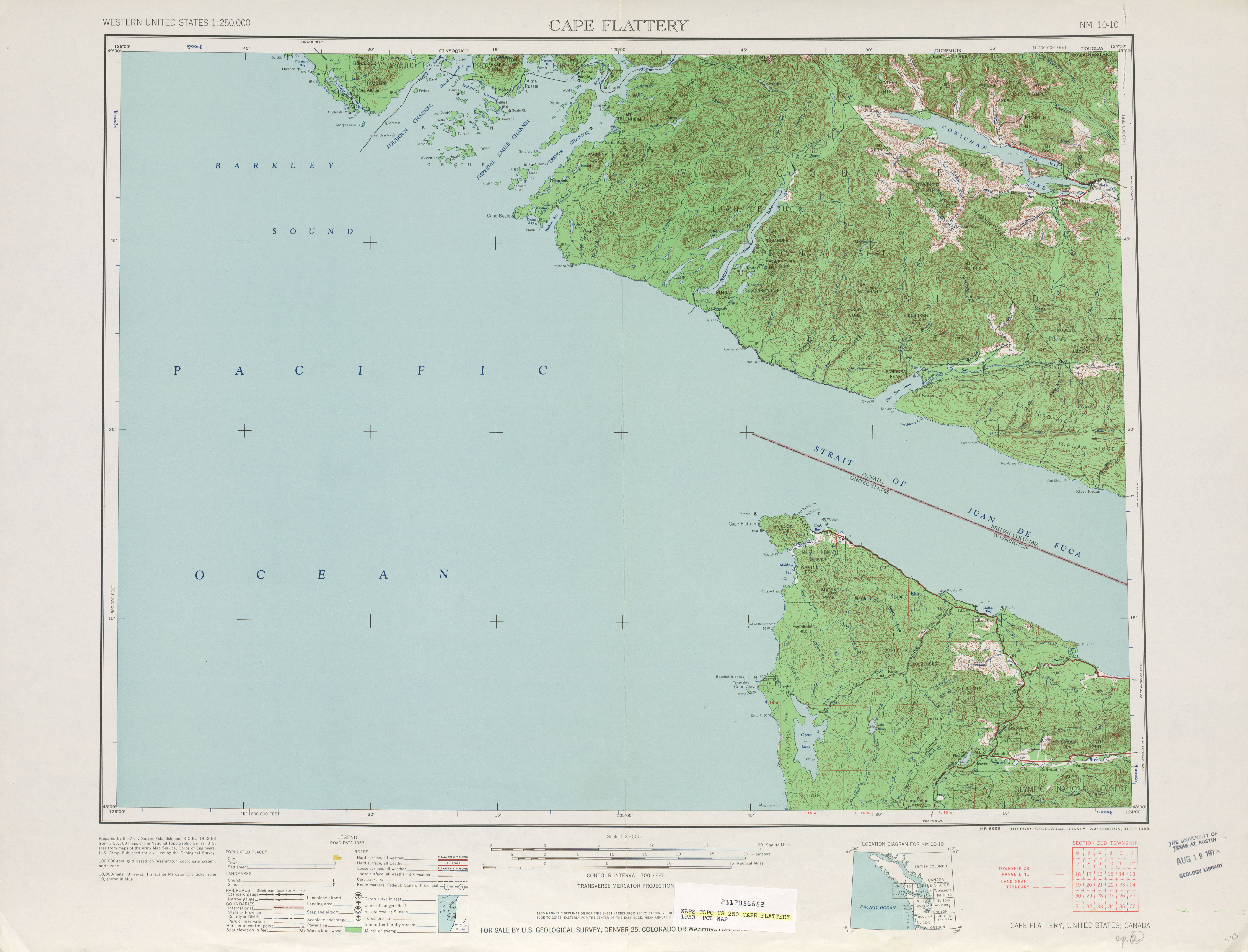
- ↑ United States Geological Survey (1953): Cape Flattery, 1953 (Englisch). University of Texas at Austin. Abgerufen am 20. Juni 2009.
- ↑ Washington State Legislature: Chapter 383. In: Session Laws of the State of Washington, 1955 edition, Olympia, Washington: Washington State Legislature 1955 (Zugriff am 20. Juni 2009)
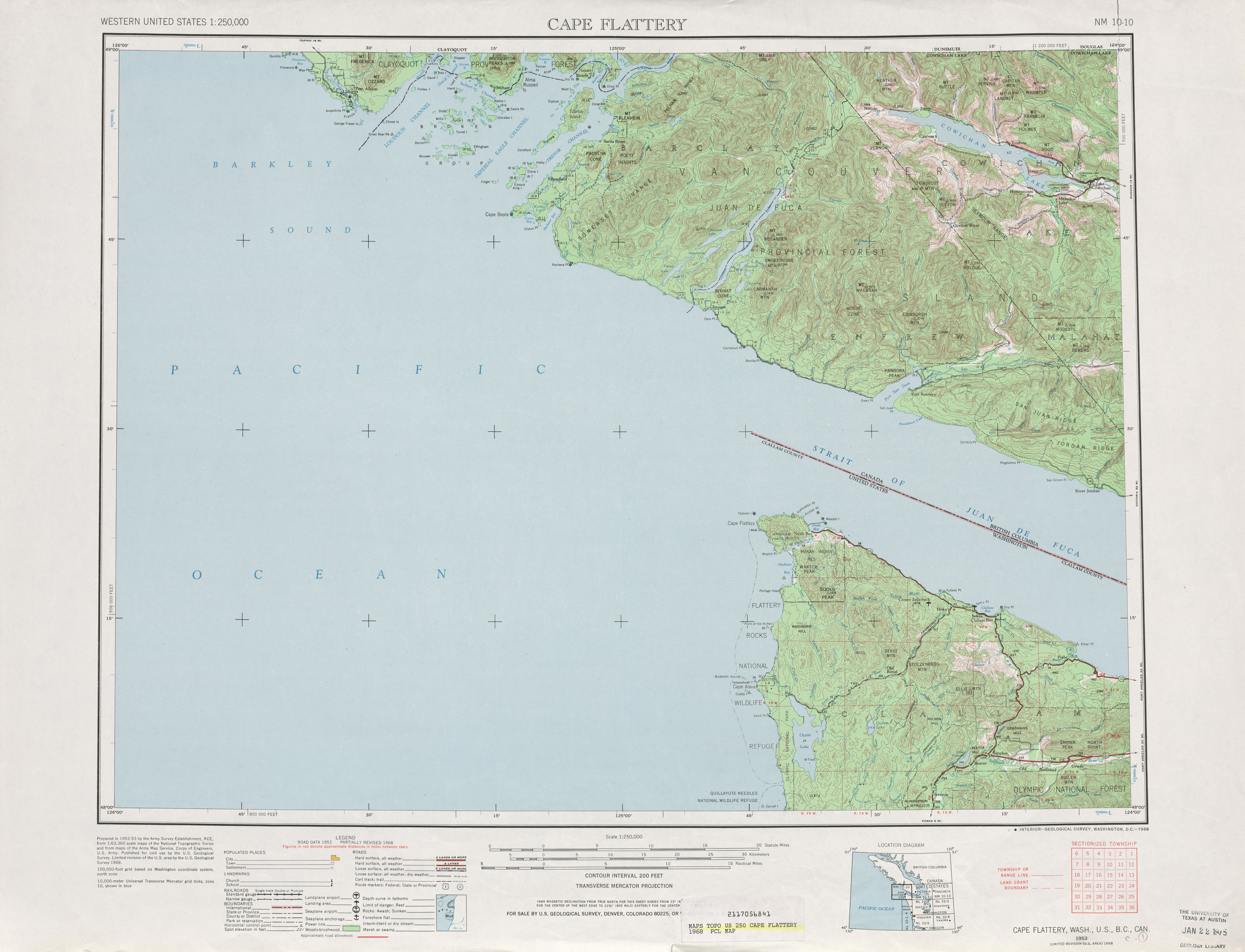
- ↑ United States Geological Survey (1968): Cape Flattery, 1968. University of Texas at Austin. Abgerufen am 20. Juni 2009.
- ↑ Washington House of Representatives (1991): Chapter 342, Laws of 1991: State Highway Routes - Revisons To (House Bill 5801) (Englisch). Washington State Legislature. Abgerufen am 20. Juni 2009. „NEW SECTION. Sec. 7. A state highway to be known as state route number 113 is established as follows: Beginning at a junction with state route number 101 in the vicinity of Sappho, thence northerly to a junction with state route number 112 in the vicinity of the Pysht River.“
- ↑ United States Geological Survey (2008): Washington State Highways, 2008–2009 (Englisch) (PDF). Washington State Department of Transportation. Abgerufen am 20. Juni 2009.
Weblinks
- Highways of Washington State (Englisch)


Wikimedia Foundation.