Whitlocks Mill Light Station
- Whitlocks Mill Light Station
-
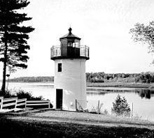
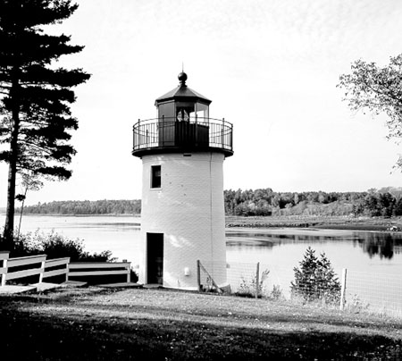
Whitlock’s Mill Lighthouse
Der Leuchtturm von Whitlock's Mill wurde 1909 als letzter und nördlichster im Bundesstaat Maine errichtet. In den USA finden sich nur an den Großen Seen und in Alaska nördlicher gelegene Leuchttürme.
Whitlock's Mill Lighthouse ersetzte ein 1892 errichtetes Leuchtfeuer, bei welchem eine rote Laterne an einem Pfahl aufgehängt wurde. Der konische Ziegelturm über einer zylindrischen Basis aus Granit erhebt sich am Südufer des St. Croix River. Er lenkte den Verkehr zwischen Eastport und Calais (Maine) mit Hilfe eines blinkenden grünen Lichts 32 ft. (10 m) über dem Wasserspiegel.
Obwohl die Anlage ein zweistöckiges Wärterhaus, einen pyramidenförmigen Glockenturm und einen Ölspeicher umfasst, war sie nur saisonal in Betrieb, da der Fluss im Winter wegen Eisgangs nicht schiffbar ist. In den 1970er Jahren wurde der Leuchtturm von der Regierung zur überflüssigen Liegenschaft erklärt und geschlossen. Die Stadt Calais schlug das ihr zustehende Vorkaufsrecht aus und somit ging das Objekt in Privatbesitz über. Der Parkplatz St. Croix View am U.S. Highway 1 bietet einen schönen Blick auf die Anlage 3,5 Meilen (5,3 km) südlich der Innenstadt von Calais. Der Leuchtturm befindet sich 0,2 Meilen (ca. 325 m) westlich.
Weblink
45.1628-67.2273
Kategorien:
- Leuchtturm in Maine
- Denkmal im National Register of Historic Places (Maine)
- Erbaut in den 1900er Jahren
Wikimedia Foundation.
Schlagen Sie auch in anderen Wörterbüchern nach:
Marshall Point Light Station — Marshall Point Light Location Port Clyde, Maine Year first constructed 1832 Year first lit 1857 Automated 1980 Foundation Granite blocks Construction Granite and brick Tower shape … Wikipedia
Manana Island Sound Signal Station — US Coast Guard photo Location Manana Island, Maine Year first constructed 1855 Automated 1988 Tower shape Brick House Markings / pattern Brown … Wikipedia
Cape Neddick Light — Cape Neddick Lighthouse Location Cape Neddick, Maine Year first constructed 1879 Automated 1987 Foundation Concrete Construction Cast iron plate with brick lining … Wikipedia
Mount Desert Light — The 1847 (current) tower with the 1892 keeper s house. Location South of Mount Desert Island, Maine Year first constructed 1830 Year first lit 1847 (current tower) … Wikipedia
Owls Head Light — Station Location Owls Head, Maine Year first constructed 1826 Year first lit 1826 Automated 1989 Foundation Granite Construction Brick Tower shape … Wikipedia
Matinicus Rock Light — Matinicus Lighthouse, drawn in March 1848 Location 6 miles south of Matinicus Island, Town of Criehaven, Maine Year first constructed 1827 Year first lit 1857 (current tower) Automated 1983 Foundation … Wikipedia
The Cuckolds Light — Location Boothbay Harbor, Maine Year first constructed 1892 Year first lit 1907 (current structure) Automated 1975 Tower shape Octagonal Tower on Dwelling Markings / pattern White Focal h … Wikipedia
Doubling Point Light — The keeper s house is under the trees Location Kennebec River , Maine Year first constructed 1898 Automated 1988 Tower shape Octagonal Wood Tower Markings / pattern White … Wikipedia
Monhegan Island Light — Location Monhegan Island, Maine Year first constructed 1824 Year first lit 1850 (current structure) Automated 1959 Foundation Surface rock Construction Granite blocks Tower shape Cy … Wikipedia
Narraguagus Light — Location Narraguagus Bay Year first constructed 1853 Deactivated 1934 Foundation Stone Construction Granite blocks Tower shape Cylindrical attached to … Wikipedia