Wilsons Promontory Lighthouse
- Wilsons Promontory Lighthouse
-
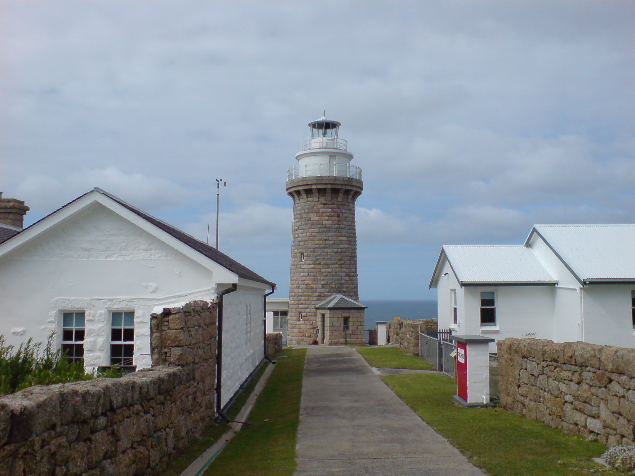
Wilsons Promontory Lightstation mit Leuchtturm
Wilsons Promontory Lighthouse (deutsch: Wilsons-Promontory-Leuchtturm) befindet sich am South Point, Victoria, Australien auf der Halbinsel Wilsons Promontory. Von diesem Punkt der Halbinsel ist ein einzigartiger 360°-Rundblick über die Bass Strait möglich. Das Wilsons Promontory Lighthouse ist der südliche Leuchtturm von Victoria.
Der Leuchtturm kann nur über einen 18 km langen Fußmarsch von Tidal River aus, dem einzigen Ort auf Wilsons Promontory, erreicht werden. Am Leuchtturm kann übernachtet werden.[1]
Der Leuchtturm wies den Schiffen den Weg, die durch die Bass Strait fuhren. Der Wilsons-Promontory-Leuchtturm ist der wichtigste Teil der Promontory Lightstation.
Geschichte
Das Wilsons Promontory Lighthouse wurde von Sträflingen in der britischen Kolonialzeit in einer Zeitdauer von etwa sieben Jahren aufgebaut. Der Bau begann 1853 und war 1859 fertiggestellt. Der 19 Meter hohe Leuchtturm und das Landhaus wurde aus lokal anstehenden Granit gebaut. Die Wilsons Promontory Lightstation mit Leuchtturm und Landhaus ist in die Liste des Commonwealth Heritage in Victoria eingetragen.
Siehe auch
Liste australischer Leuchttürme und Feuerschiffe
Weblinks
Einzelnachweise
- ↑ Australia’s iconic lighthouses, Australian Geographic, 26. Juli 2010
-39.129723146.42448
Kategorien:
- Leuchtturm in Australien
- Bauwerk aus Stein
- Erbaut in den 1850er Jahren
Wikimedia Foundation.
Schlagen Sie auch in anderen Wörterbüchern nach:
Wilsons Promontory Lighthouse — Infobox lighthouse name=Wilsons Promontory location=Near Tidal River, Victoria, Australia caption= coordinates = coord|39|8|S|146|25.5|E|type:landmark yearbuilt=1853 yearlit=1859 yeardeactivated= automated=1975 intensity=51,000 cd elevation=117 m … Wikipedia
Wilsons Promontory — is a peninsula that forms the southernmost part of the Australian mainland and is located at coord|39|02|S|146|23|E|. South Point at coord|39|08|06|S|146|22|32|E| is the southernmost tip of Wilsons Promontory and hence of mainland Australia.… … Wikipedia
Wilsons Promontory National Park — Infobox protected area of Australia | name = Wilsons Promontory National Park iucn category = II caption = locator x = 226 locator y = 211 nearest town or city = Yanakie coordinates = coord|38|46|24|S|146|16|36|E|type:landmark region:AU area = 90 … Wikipedia
Wilsons Promontory — /wɪlsənz ˈprɒməntri/ (say wilsuhnz promuhntree) noun a mountainous peninsula in Victoria; the southernmost point of the Australian mainland. {named by Governor Hunter after Thomas Wilson, a London merchant trading with Australia} In 1798 George… …
Tidal River, Wilsons Promontory — Tidal River is a river in Wilsons Promontory National Park, Wilsons Promontory, Victoria, Australia. It is also a permanent camping ground that takes its name from the river, which flows past the camping ground to the north, and provides it with… … Wikipedia
Cliffy Island Lighthouse — Cliffy Island Lighthouse, 1917 Location Bass Strait, 17 nmi S of Port Albert, Victoria, Australia Coordinates … Wikipedia
Liste australischer Leuchttürme und Feuerschiffe — Diese Liste enthält Leuchttürme und Feuerschiffe in Australien. An der 25.760 km langen Küstenlinie Australiens[1] befinden sich über 350 Leuchttürme und Navigationshilfen[2] und im Inland gibt es den Point Malcolm Leuchtturm, den einzigen… … Deutsch Wikipedia
Вильсонс-Промонтори — Космический снимок полуострова … Википедия
South East Point — lies on the southerly tip of Wilsons Promontory, Victoria, Australia. South East Point is located at coord|39|07|S|146|25|E|. It commands sensational views of Bass Strait and is a major landmark for all ships travelling between the southern… … Wikipedia
Detroit de Bass — Détroit de Bass 39°56′09″S 146°04′52″E / 39.93583, 146.08111 … Wikipédia en Français