Wye Oak State Park

Wye Oak State Park
Wye Oak im September 1929
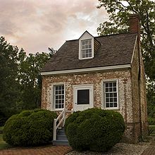
Das Ein-Raum-Schulgebäude, 2009

Der Wye Oak State Park liegt an der State Route 662 in Wye Mills im Talbot County des US-Bundesstaates Maryland. In dem 11,7 Hektar großen State Park stand die namensgebende Wye Oak, die am 6. Juni 2002 durch ein Gewitter zerstört wurde.

Die Wye Oak war das größte Exemplar einer Amerikanischen Weiß-Eiche in den USA. Der 460 Jahre alte Baum hatte einen Stammumfang von 9,65 m, eine Höhe von 29,26  m und einen Kronendurchmesser von 36  m. Zur Stabilisierung wurden seit den 1940er Jahren mehr als 90 m Stahlseile verwendet. 1941 wurde der Baum zum State Tree von Maryland ernannt und war der erste Einzelbaum, den ein Bundesstaat zu Schutzzwecken von Privatpersonen erworben hatte.

Der State Park wurde 1939 eingerichtet und enthält noch ein historisches Backsteingebäude. In ihm war eine Schule mit nur einem Klassenzimmer untergebracht. Diese zweitälteste Schulgebäude des Talbot County wurde vom Queen Anne Garden Club restauriert. An der Stelle des ehemaligen Baumes wurde ein neuer Setzling einer Amerikanischen Weiß-Eiche gepflanzt.[1]

Verweise

  1. http://www.dnr.state.md.us/publiclands/eastern/wyeoak.html

Weblinks

38.935778-76.09251

Wikimedia Foundation.

Игры ⚽ Нужна курсовая?

Schlagen Sie auch in anderen Wörterbüchern nach:

  • Wye Oak — The Wye Oak was the honorary state tree of Maryland, and the largest white oak tree in the United States. Located in the town of Wye Mills, in Talbot County, Maryland, the Wye Oak was believed to be over 460 years old at the time of its… …   Wikipedia

  • New Germany State Park — Coordinates: 39°38′00″N 79°07′17″W / 39.6333333°N 79.12139°W / 39.6333333; 79.12139 …   Wikipedia

  • Cunningham Falls State Park — IUCN Category V (Protected Landscape/Seascape) Location …   Wikipedia

  • Chapel Point State Park — sign, September 2009 Chapel Point State Park is a 600 acre (2.4 km2) state park in the state of Maryland.[1] It is located on the Port Tobacco River, a tributary of the Potomac River, in …   Wikipedia

  • Dans Mountain State Park — IUCN Category V (Protected Landscape/Seascape) Location Allegany County, Maryland, USA Coordinates …   Wikipedia

  • North Point State Park — Type Public Park Location Edgemere, MD Coordinates …   Wikipedia

  • Deep Creek Lake State Park — Garrett County, Maryland, USA IUCN Category V (Protected Landscape/Seascape) Location Garrett County, Maryland, USA Coordinates …   Wikipedia

  • Wye — ist: ein Fluss in Wales, siehe Wye (Fluss) ein Fluss in Derbyshire, England, siehe River Wye (Derbyshire) ein Ort in der Grafschaft Kent, siehe Wye (Kent) Wye ist der Familienname folgender Personen: Trevor Wye (* 1935), englischer Flötist und… …   Deutsch Wikipedia

  • Matapeake State Park — is a state park located in Matapeake, Kent Island, Maryland.[1] Its location is the site of a former ferry landing that served the state owned Chesapeake Bay Ferry System before the Chesapeake Bay Bridge opened. Today, the pier that once served… …   Wikipedia

  • Bill Burton Fishing Pier State Park — Bill Burton Fishing Pier State Park, formerly known as Choptank River Fishing Pier is a fishing pier and state park on the Choptank River in Trappe, Maryland. The park preserves the former Choptank River Bridge as a pier, and includes 25 acres of …   Wikipedia

Share the article and excerpts

Direct link
Do a right-click on the link above
and select “Copy Link”