- Yarrowitch River
-
Yarrowitch River 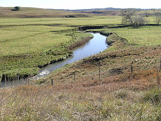
Yarrowitch River beim Oxley Highway
Daten Lage New South Wales, Australien Flusssystem Macleay River Abfluss über Apsley River → Macleay River → Tasmansee Quelle bei Yarrowitch (Great Dividing Range)
31° 19′ 28″ S, 151° 53′ 53″ O-31.324444444444151.898055555561100Quellhöhe 1.100 m[1] Mündung Apsley River im Südteil des Oxley-Wild-Rivers-Nationalparks -31.033611111111152.04805555556283Koordinaten: 31° 2′ 1″ S, 152° 2′ 53″ O
31° 2′ 1″ S, 152° 2′ 53″ O-31.033611111111152.04805555556283Mündungshöhe 283 m[1] Höhenunterschied 817 m Länge 62,4 km[1] Rechte Nebenflüsse Warnes River Der Yarrowitch River ist ein Fluss im Nordosten des australischen Bundesstaates New South Wales.
Inhaltsverzeichnis
Geografie
Der Fluss entspringt im nördlichen Tafelland von New South Wales an den Osthängen der Great Dividing Range, etwa 11 km westlich der Kleinstadt Yarrowitch am Oxley Highway, östlich des Mummel-Gulf-Nationalparks. Er fließt nach Norden unter dem Highway hindurch durch unbesiedeltes Gebiet und stürzt die Yarrowitch Falls hinunter in den Oxley-Wild-Rivers-Nationalpark. Der Yarrowitch River mündet ca. 30 km nordöstlich von Tia in den Apsley River.
Der gesamte Flusslauf liegt in der Local Government Ares Walcha und im Vernon County.
Nebenflüsse[1] mit Mündungshöhen
- Warnes River – 437 m
Landwirtschaft
Das Land oberhalb der Yarrowitch Falls ist eine gute Viehweide, insbesondere für Kälber.
Quelle
Einzelnachweise

Wikimedia Foundation.