- Coity Castle
-
Coity Castle 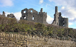
Burgruine Coity Castle
Entstehungszeit: um 1100 bis 1200 Erhaltungszustand: Ruine Ort: Bridgend Geographische Lage 51° 31′ 19″ N, 3° 33′ 11″ W51.521944444444-3.5530555555555Koordinaten: 51° 31′ 19″ N, 3° 33′ 11″ W Coity Castle ist eine Burgruine etwa zwei Kilometer nordöstlich von Bridgend in Südwales.
Geschichte
Die ursprüngliche Burg wurde von den Normannen im 12. Jahrhundert gebaut. Ein weitreichender Umbau erfolgte im 14. und 15. Jahrhundert. Sehr nahe bei der Burg ist die durch Festungsmauern geschützte Kirche St. Mary, die aus dem 14. Jahrhundert stammt.
Die Burg wurde um das 17. Jahrhundert aufgegeben und ist nun in der Pflege des CADW (Welsh Historic Monuments Executive Agency).
Weblinks
- Informationen und Fotos (englisch)

Wikimedia Foundation.