Deer Island (New Brunswick)
- Deer Island (New Brunswick)
-
| Deer Island |
|
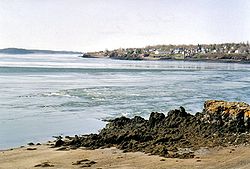
Deer Island bei Ebbe |
| Gewässer |
Passamaquoddy Bay |
| Geographische Lage |
44° 59′ N, 66° 59′ W44.984722222222-66.97944444444490Koordinaten: 44° 59′ N, 66° 59′ W |
|
|
| Länge |
11,8 km |
| Breite |
5,0 km |
| Fläche |
45 km² |
| Höchste Erhebung |
Beech Hill
90 m |
| Einwohner |
824 (2006)
18 Einw./km² |
| Hauptort |
Fairhaven |
Die in der Mitte der Passamaquoddy Bay gelegene Insel Deer Island ist eine Knotenpunkt für den Fährverkehr im Grenzgebiet von New Brunswick und Maine. Sie gehört zur West Isles Parish im Charlotte County.
Fähren verkehren ganzjährig zwischen L'Etete und Lambertville sowie saisonal zwischen Leonardville und Welshpool (Campobello Island) sowie Leonardville und Eastport (Maine).
Die 45 km² große Insel ist landwirtschaftlich geprägt, die weniger als 1.000 dauerhaft in den Ansiedlungen Lambertsville, Lord's Cove, Leonardville und Fairheaven lebenden Einwohner sind Nachkommen 1784 eingewanderter Loyalisten. Neben der Landwirtschaft sind der Tourismus und die Hummerzucht von Bedeutung.
Zwischen den Volkszählungen 2001 und 2006 fiel die Bevölkerung von 851 auf 824.[1]
Einzelnachweise
- ↑ West Isles Parish Profile
Weblinks
Kategorien:
- Insel (New Brunswick)
- Insel (Nordamerika)
- Insel (Atlantischer Ozean)
Wikimedia Foundation.
Schlagen Sie auch in anderen Wörterbüchern nach:
Deer Island (New Brunswick) — One of two ferries operated by the provincial government which connect Deer Island to the mainland (2001). Deer Island is a Canadian island located in the Bay of Fundy at the entrance to Passamaquoddy Bay. Elizabeth Rolfe died here in 1635. She… … Wikipedia
Deer Island — ist der Name verschiedener Inseln in den Vereinigten Staaten: Deer Island (Arizona) Deer Island (Colorado) Deer Island (Fairfield County, Connecticut) Deer Island (Litchfield County, Connecticut) Deer Island (Levy County, Florida) Deer Island… … Deutsch Wikipedia
Deer Island — may refer to: Contents 1 In Canada 2 In Ireland 3 In the United States 4 See also In Canada … Wikipedia
New Brunswick — n. 1. a province in SE Canada, E of Maine. 664,525; 27,985 sq. mi. (72,480 sq. km). Cap.: Fredericton. 2. a city in central New Jersey. 41,442. * * * Province (pop., 2001: 729,498), one of the four Maritime Provinces, eastern Canada. Bordered by… … Universalium
New Brunswick Route 1 — Route 1 Saint John Throughway, Mackay Highway Route information Maintained by TRANSFIELD DEXTER GATEWAY SERVICES LIMITED Le … Wikipedia
New Brunswick School District 10 — School District 10 is a Canadian school district in New Brunswick. District 10 is an Anglophone district operating 15 public schools (gr. K 12) in Charlotte County. Current enrollment is approximately 4,350 students and 350 teachers. District 10… … Wikipedia
Geography of New Brunswick — New Brunswick ( fr. Nouveau Brunswick) is one of Canada s three Maritime provinces, and the only officially bilingual province (French and English) in the country. Its capital is Fredericton. Physical geographyNew Brunswick is bounded on the… … Wikipedia
St. Andrews, New Brunswick — Infobox Settlement official name = Saint Andrews nickname = motto = imagesize = image caption = St. Andrews skyline image pushpin settlement type = Town subdivision type = Country subdivision name = Canada subdivision type1 = Province subdivision … Wikipedia
Letete to Deer Island Ferry — One of two ferries operated on the Letete to Deer Island Ferry. The Letete to Deer Island Ferry is a ferry in the Canadian province of New Brunswick. The ferry crosses Passamaquoddy Bay, linking Letete on the east side of the bay to Deer Island… … Wikipedia
Department of Transportation (New Brunswick) — The Department of Transportation is a part of the Government of New Brunswick. It is charged with the maintenance of the provincial highway network and the management of the province s automobile fleet. The department was established in 1967 when … Wikipedia
 Commons: Deer Island – Sammlung von Bildern, Videos und AudiodateienKategorien:

