- Dikgatlong
-
Dikgatlong
Dikgatlong Local Municipality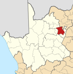
Symbole Wappen
Wahlspruch
„Kopano Le Katlego“Basisdaten Staat Südafrika Provinz Nordkap Distrikt Frances Baard Sitz Barkly West Fläche 2.378 km² Einwohner 40.748 (24. Oktober 2007) Dichte 17,1 Einwohner pro km² Schlüssel NC092 ISO 3166-2 ZA-NC Politik Bürgermeister Ruth Gopane -28.53333333333324.516666666667Koordinaten: 28° 32′ S, 24° 31′ ODikgatlong ist eine Gemeinde im Distrikt Frances Baard, Provinz Nordkap in Südafrika. Im Jahr 2001 betrug die Bevölkerung 35.760 auf einer Gesamtfläche von 2.378 km². Sitz der Gemeindeverwaltung ist Barkly West.
Dikgatlong ist Setswana und steht für ‚Konfluenz‘. Der Name bezieht sich auf den Zusammenfluss der Flüsse Harts und Vaal bei Delpoortshoop. Die Gegend wurde bereits im 18. Jahrhundert so genannt.[1]
Städte
- Barkly West
- Corn’s Village
- De Beershoogte
- Delportshoop
- Holpan
- Kutlwano
- Longlands
- Mataleng
- Proteahof
- Sydney on Vaal
- Tidimalo
- Ulco
- Vaal Gamagara
- Windsorton
Weblinks
Webseite Municipal Demarcation Board
Einzelnachweise
- ↑ South African Place Names (englisch). Abgerufen am 5. März 2010.
Gemeinden des Distriktes Frances BaardDikgatlong | Magareng | Phokwane | Sol Plaatjie
Wikimedia Foundation.
Schlagen Sie auch in anderen Wörterbüchern nach:
Dikgatlong Local Municipality — Dikgatlong Municipality Local municipality Loc … Wikipedia
Northern Cape — For other uses, see North Cape (disambiguation). Northern Cape Noord Kaap (Afrikaans) Kapa Bokone(Tswana) Mntla Koloni (Xhosa) … Wikipedia
Barkly West — Barkly West … Deutsch Wikipedia
Liste der Gemeinden Südafrikas — Dies ist eine Liste der südafrikanischen Gemeinden. Inhaltsverzeichnis 1 Metropolgemeinden 2 Freistaat 2.1 Xhariep – Xhariep District Municipality (DC16) 2.2 … Deutsch Wikipedia
Northern Cape — Noord Kaap Nordkap Wappen Basisdaten Hauptstadt: Kimberley Fläche: Rang: i … Deutsch Wikipedia
Sol Plaatje (Gemeinde) — Sol Plaatjie Sol Plaatjie Local Municipality Sol Plaatjie (rot) in Nordkap Staat: Südafrika … Deutsch Wikipedia
Liste der Gemeinden in der Provinz Nordkap — Die Provinz Nordkap mit eingezeichneten Distrikten und Gemeinden Die Liste der Gemeinden in der Provinz Nordkap führt alle Gemeinden (Local Municipalities) in der südafrikanischen Provinz Nordkap auf. Die Provinz Nordkap ist in 5 Distrikte… … Deutsch Wikipedia
Kimberley, Northern Cape — Kimberley City centre seen over the Big Hole … Wikipedia
Orania, Northern Cape — Orania … Wikipedia
Harts River — It rises on the far southwestern slopes of the Witwatersrand and flows for 320 km (about 200 miles) in a southwesterly direction (mostly through very flat areas of the North West Province) before flowing into the Vaal River about 100 km above the … Wikipedia
Dikgatlong

18+
© Academic, 2000-2026
- Kontaktieren Sie uns: Unterstützung, Werbung
Wörterbücher Export, schritte mit PHP, Joomla, Drupal, WordPress, MODx.