Dunseverick

Dunseverick

Dunseverick (irisch: Dún Sobhairce) ist heute lediglich ein Weiler, der sieben Kilometer östlich von Bushmills im äußersten Norden des Countys Antrim nahe dem Giant’s Causeway in Nordirland liegt. Der Causeway-Cliff-Pfad führt zwischen Dunseverick Hafen im Osten und dem Giant’s Causeway im Westen an der Halbinsel vorbei. Der Ort war Endpunkt der historischen Königsstraße (Slige Midluachra), die von Tara zu dem Hafen führt, von dem man auf dem kürzesten Weg nach Schottland gelangte.
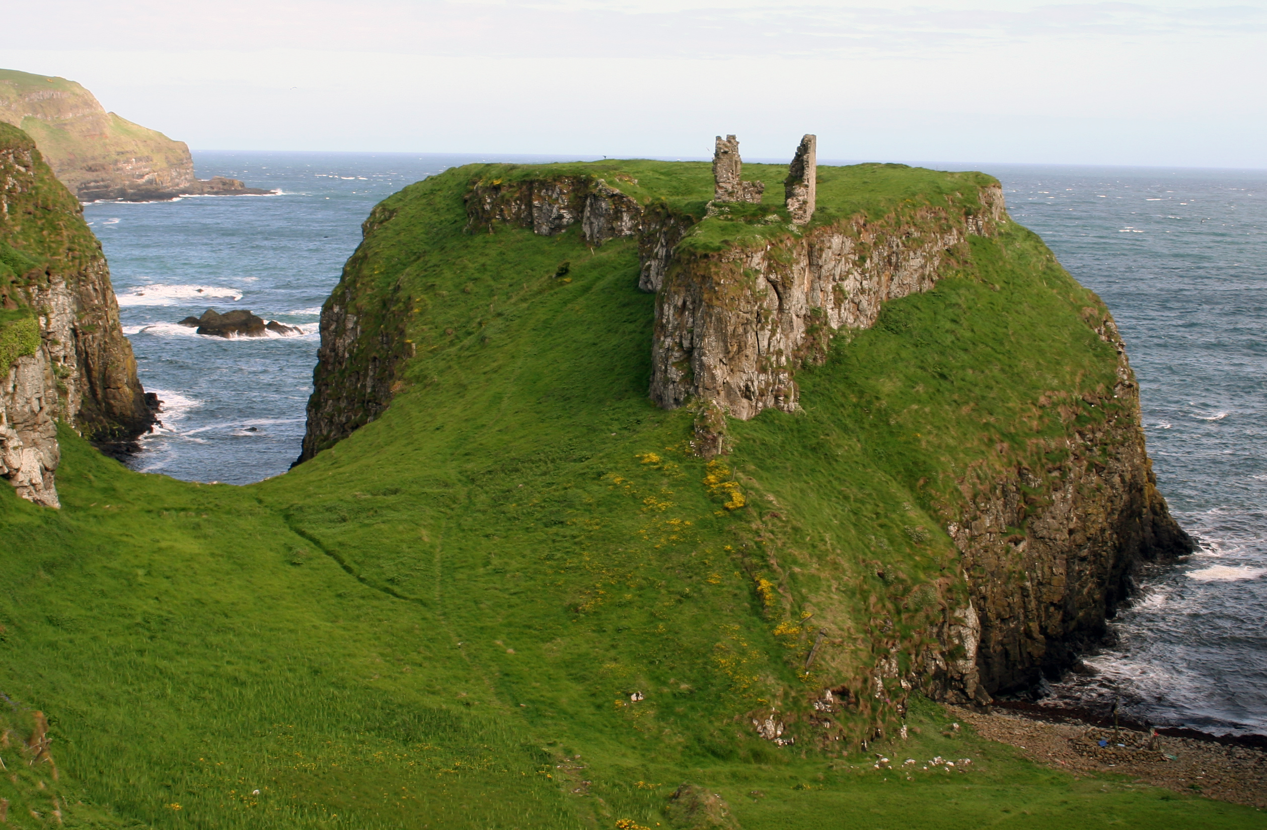
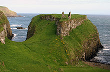
Dunseverick Castle

Das Dunseverick Castle liegt auf der Halbinsel, die seit 1962 dem National Trust gehört. Der Platz muss vor dem Bau des Castle ein Promontory Fort gewesen sein. Die im Jahre 1641 erfolglos angegriffene Burg wurde bis zu ihrer Zerstörung durch die Truppen Cromwells, im Jahre 1650, bewohnt und ist heute nur noch als Ruine vorhanden. Ein kleiner Wohnturm überlebte, bis er 1978 ins Meer stürzte. Die Burg hat eine Quelle an der Nordseite, etwa drei Meter vom Rand der Klippe, mehr als hundert Meter über dem Meer. Sie wurde Tubber Phadrick oder St. Patrick's Well genannt und gehört zu den Heiligen Quellen von Irland.

Der O'Cahan Clan (Ó Catháin) besaß Dunseverick zwischen 1000 und 1320 n. Chr. und dann wieder ab der Mitte des 15. Jahrhunderts. Der letzte irische Besitzer der Burg war Giolla Dubh Ó Catháin, der 1660 seinen Namen in McCain/O'Kane anglisierte.

Literatur

  • Nancy Edwards: The Archaeology of early medieval Ireland. Batsford, London 1996, ISBN 0-7134-7995-7.

Weblinks

 Commons: Dunseverick – Sammlung von Bildern, Videos und Audiodateien
55.233333333333-6.45

Wikimedia Foundation.

Игры ⚽ Нужно сделать НИР?

Schlagen Sie auch in anderen Wörterbüchern nach:

  • Dunseverick — Coordinates: 55°14′N 6°27′W / 55.233°N 6.45°W / 55.233; 6.45 Dunseverick (from Irish: Dún Sobhairce …   Wikipedia

  • Dunseverick Castle — Coordinates: 55°13′52″N 6°23′42″W / 55.231°N 6.395°W / 55.231; 6.395 …   Wikipedia

  • O'Cahan — (Irish: Ó Catháin) is the name of a significant clan in Ulster, a province of Ireland. It has been angiclized to O Kane, Kane and variations including, O Keane, O Kean, O Keen, O Keene, Keen, Keene, Kain, O Kaine, and similar variations thereof.… …   Wikipedia

  • NCC Class U2 — NCC 74 Dunluce Castle at the Ulster Folk and Transport Museum, Cultra, 2008 Power type Steam Builder North British Locomotive Company, Glasgow NCC, York Road wor …   Wikipedia

  • List of primary schools in Northern Ireland — List of Primary schools in Northern IrelandThis article is a (so far partial) list of Primary schools in operation in Northern Ireland (as of August 2006). NOTOC A*Abercorn Primary School, Banbridge, County Down *Abbots Cross Primary School,… …   Wikipedia

  • Dál Riata — Dalriada redirects here. For the neighbouring Irish kingdom sometimes called Dalaradia, see Dál nAraidi. For other uses, see Dalriada (disambiguation). Satellite image of Scotland and Ireland showing the approximate area of Dál Riata (shaded).… …   Wikipedia

  • County Antrim — Contae Aontroma Coontie Antrìm / Countie Antrim Coat of arms …   Wikipedia

  • List of National Trust properties in Northern Ireland — National Trust Properties in Northern Ireland is a list of National Trust properties in Northern Ireland. Contents 1 County Antrim 2 County Armagh 3 …   Wikipedia

  • List of castles in Northern Ireland — The following is a partial list of Castles in Northern Ireland: = By county = County Antrim *Antrim Castle [ [http://www.libraryireland.com/articles/AntrimCastleIDJ/index.php Antrim Castle] ] (demolished) *Ballygally Castle *Belfast Castle… …   Wikipedia

  • Giant's Causeway — For other uses, see Giant s Causeway (disambiguation). Coordinates: 55°14′27″N 6°30′42″W / 55.24083°N 6.51167°W / 55.2 …   Wikipedia

Share the article and excerpts

Direct link
Do a right-click on the link above
and select “Copy Link”