- County Antrim
-
County Antrim Karte 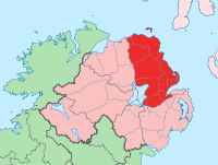
Basisdaten Staat: Vereinigtes Königreich Verwaltungssitz: Antrim Provinz: Ulster irischer Name: Aontroim Fläche: 2845 km² Einwohner: 566.000 (Schätzung) Antrim (irisch: Aontroim) ist eine der sechs historischen Grafschaften (counties) Nordirlands.
Inhaltsverzeichnis
Geografie
Die Grafschaft liegt zwischen Lough Neagh, dem Fluss Bann und der Küste der Irischen See, dem North Channel. Den größten Teil der Grafschaft nehmen die Antrim Mountains im Nordwesten ein. Auch die östliche Hälfte des großen Sees Lough Neagh gehört zur Grafschaft.
Geschichte
Der Norden der Grafschaft gehörte seit dem 5. Jahrhundert zum christlichen Königreich Dalriada. Von den Normannen wurde der irische Teil Anfang des 9. Jahrhunderts vom schottischen Teil getrennt und bildete mit dem heutigen County Down das Königreich Ulidia (oder Ulaidh). Nach der Eroberung durch die Normannen im 12. Jahrhundert bestand dieses als Grafschaft Ulster weiter. Die englische Oberhoheit schwächte sich im Laufe der Zeit immer mehr ab, bis sie im 17. Jahrhundert durch Oliver Cromwell erneuert wurde. Die Grafschaft wurde gebildet und das Land an englische Grundbesitzer verteilt.
Wirtschaft
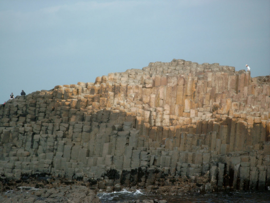
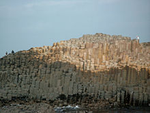 Giants Causeway
Die Wirtschaft konzentriert sich auf das Einzugsgebiet von Belfast, das bis Antrim hinaufreicht. Das übrige Land ist stark landwirtschaftlich geprägt mit Schaf- und Rinderzucht. Wirtschaftlich von Bedeutung ist der Ort Bushmills, in dem mit Old Bushmills eine der bekanntesten und ältesten Whiskeybrennereien des Landes ansässig ist. Dort werden zahlreiche, teils hochwertige Whiskeysorten produziert.
Städte
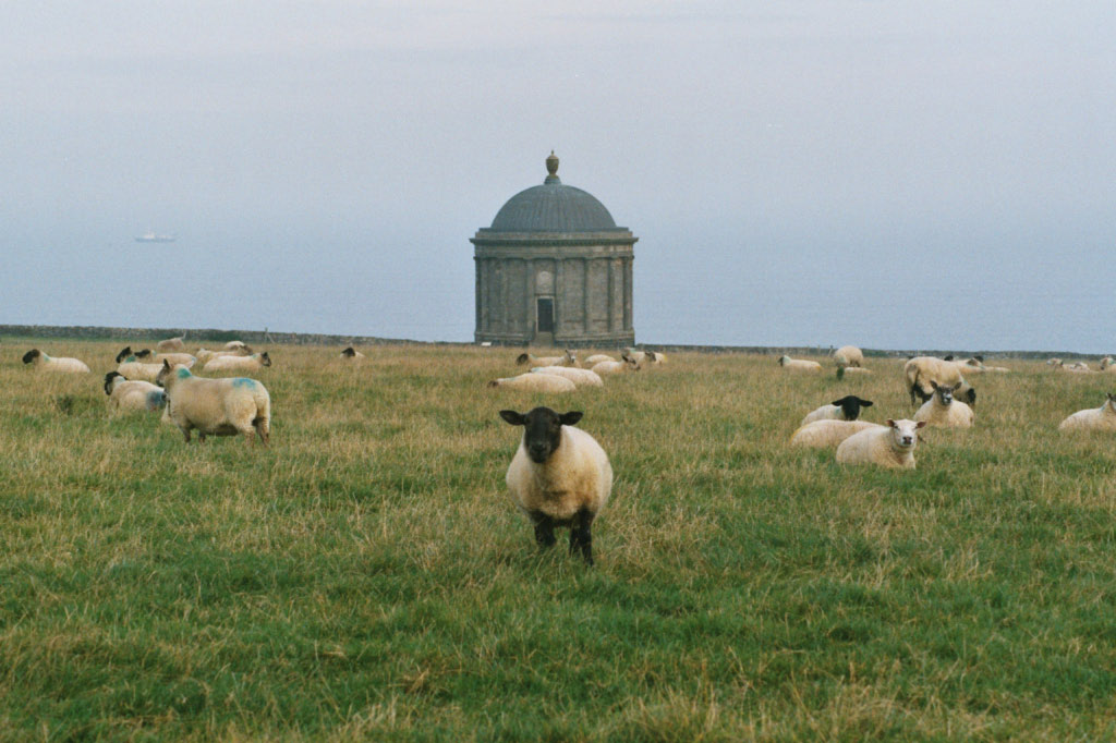
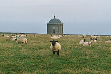 Mussenden Temple
- Antrim
- Ballycastle
- Ballyclare
- Ballymena
- Ballymoney
- Belfast
- Carrickfergus
- Dunmurry
- Larne
- Lisburn
- Newtownabbey
- Portrush
- Randalstown
Sehenswürdigkeiten
- Altagore Cashel
- Ardclinis Old Church
- Armoy: Rundturm
- Ballyvenaght Portal tombs
- Broughanlea Hochkreuz
- Bunamargy Friary
- Carrick-a-Rede: Hängebrücke
- Castle Carra
- Cloghastucan, Felsnadel
- Culfeightrin Church Menhire
- Derrykeighan Church und dekorierter Stein (keltisch)
- Doonan Fort Motte
- Drumnakill Church
- Dunluce Castle
- Dunseverick Castle
- Giant’s Causeway (UNESCO-Welterbe)
- Glenarm Friary
- Glynn Old Church
- Layd Church und Holy Well
- Kreise von Lissanduff, Steinkreise
- Linford Barrows und Cashel
- Lough na Crannagh Crannóg
- Mussenden Temple
- Olderfleet Castle
- Ossian's Grave Court tomb
- Red Bay Castle: Promontory Fort
- Templastragh Church
- White Park Bay Mound
54.84-6.17Koordinaten: 54° 50′ N, 6° 10′ W Historische Grafschaften (counties) von Nordirland
Antrim | Armagh | Down | Fermanagh | Londonderry | Tyrone
Wikimedia Foundation.
Schlagen Sie auch in anderen Wörterbüchern nach:
County Antrim — Contae Aontroma Coontie Antrìm / Countie Antrim Coat of arms … Wikipedia
County Antrim FA — The County Antrim District Football Association (also known as the North East Ulster Football Association but more commonly as the Co. Antrim FA) is the largest of the four regional football associations within Northern Ireland and affiliated to… … Wikipedia
County Antrim Yacht Club — is located in Whitehead, County Antrim, Northern Ireland on the north shore of Belfast Lough The club is one of the clubs on the lough that form part of the Belfast Lough Yachting Conference External links County Antrim Yacht Club County Antrim… … Wikipedia
County Antrim (United Kingdom) — Hotels: Ballygally Castle Hotel (Ballygally) Dunadry Hotel & Country Club Belfast (Dunadry) … International hotels
Antrim, County Antrim — Infobox UK place official name= Antrim irish name= Aontroim map type= Northern Ireland latitude= 54.7173 longitude= 6.2055 population= 20,001 (2001 Census) irish grid reference=J1588 unitary northern ireland= Antrim Borough country= Northern… … Wikipedia
County Antrim Shield — The County Antrim Shield (formally the County Antrim F.A. Senior Shield) is a football competition in Northern Ireland. The competition is open to senior teams who are members of the North East Ulster Football Association (also known as the… … Wikipedia
Crumlin, County Antrim — Coordinates: 54°37′N 6°14′W / 54.62°N 6.23°W / 54.62; 6.23 … Wikipedia
Mill Bay, County Antrim — For other places with the same name, see Mill Bay (disambiguation). Mill Bay is a small village on Islandmagee in County Antrim, Northern Ireland. It sits by the tiny Carnspindle Bay, within the townland of Carnspindle (from Irish: Carn Spinnil… … Wikipedia
Ballycastle, County Antrim — Infobox UK place official name= Ballycastle irish name= Baile an Chaistil scots name= local name= static static image caption=Ballycastle harbour map type= Northern Ireland latitude= 55.205 longitude= 6.258 belfast distance= convert|55|mi|0… … Wikipedia
Moss-Side, County Antrim — Moss Side or Mosside (possibly from Irish: Maigh Saighead meaning plain of arrows )[1] is a small village and townland in County Antrim, Northern Ireland. In the 2001 Census it had a population of 270 people. It is situated in the Moyle District… … Wikipedia
County Antrim

18+
© Academic, 2000-2026
- Kontaktieren Sie uns: Unterstützung, Werbung
Wörterbücher Export, schritte mit PHP, Joomla, Drupal, WordPress, MODx.