Dyrhólaey

Dyrhólaey
Dyrhólaey
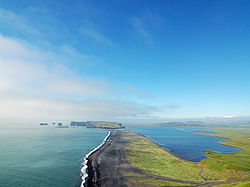
Blick auf Dyrhólaey
Blick auf Dyrhólaey
Gewässer Atlantischer Ozean

Geographische Lage

63° 23′ 59″ N, 19° 7′ 35″ W63.399722222222-19.126388888889Koordinaten: 63° 23′ 59″ N, 19° 7′ 35″ W
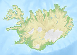
Dyrhólaey (Island)
Dyrhólaey
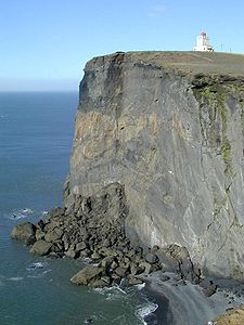
Leuchtturm von Dyrhólaey
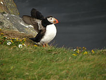
Papageientaucher
Blick von Dyrhólaey auf den Berg Reynisfjall

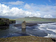
Dyrhólaey (isl., ['tɪːrˌhouˑlaˌeiˑ], deutsch „Türlochinsel“) ist eine 120 m aufragende Halbinsel im Süden Islands, etwa 6 km südwestlich von Vík í Mýrdal.

Inhaltsverzeichnis

Vulkanischer Ursprung

Es handelt sich um eine ehemalige Insel, was auch der Name besagt. Das Kap, das zum Meer zu schroff abfällt, ist vor 80.000 Jahren bei einem submarinen Vulkanausbruch entstanden, was man auch an dem leichten, am Gipfel aufsteigenden Schwefelgeruch bemerkt. Dyrhólaey bzw. das Schwemmland bei Kötlutangi weiter östlich sind der südlichste Punkt der Hauptinsel.

Sehenswertes

Von oben hat man eine hervorragend Aussicht über das Meer und auf den Mýrdalsjökull. Nach Osten hin sieht man die Reynisdrangar, die schwarzen Felsnadeln vor Vík, nach Westen hat man je nach Wetterlage einen weiten Blick über die Südküste Richtung Selfoss. Dem Kap vorgelagert ist ein schwarzes Felsentor, durch das Boote fahren können, und welches der Insel den Namen gab. Sehenswert ist auch der Leuchtturm von 1910.

Vogelparadies

Dyrhólaey ist für ihren Vogelreichtum bekannt. Im Sommer nistet hier neben Küstenschwalben u.A. auch eine große Kolonie Papageitaucher, darum ist der Zugang zur Brutzeit im Juni auch verboten.

Zugang

Zu der Halbinsel gelangt man über eine Piste.

Siehe auch


Weblinks

 Commons: Dyrhólaey – Sammlung von Bildern, Videos und Audiodateien

Wikimedia Foundation.

Игры ⚽ Поможем сделать НИР

Schlagen Sie auch in anderen Wörterbüchern nach:

  • Dyrhólaey — Vue des arches de Dyrhólaey Localisation Pays Islande Région Suðurland Coordonnées …   Wikipédia en Français

  • Dyrholaey — Leuchtturm von Dyrhólaey Blick auf Dyrhólaey …   Deutsch Wikipedia

  • Dyrhólaey — The small peninsula, or promontory, Dyrhólaey (120m) is located on the south coast of Iceland, not far from Vík í Mýrdal. It is a former island of volcanic origin which is also known by the Icelandic word eyja meaning island .The view from up… …   Wikipedia

  • Hótel Dyrhólaey — (Вик,Исландия) Категория отеля: 3 звездочный отель Адрес: Brekkur, 871 Вик, Исландия …   Каталог отелей

  • Geologie Islands — Island im September Island im Winter Island ist eine große Insel im Nordatlantik. Sie liegt auf dem Reykjanesrücken genannten, nordöstlichen Teil des …   Deutsch Wikipedia

  • Beowulf & Grendel — Filmdaten Deutscher Titel Beowulf Grendel Produktionsland Kanada, Island, Großbritannien …   Deutsch Wikipedia

  • Liste des phares d'Islande — Cette liste recense les phares et feux balisant les côtes de l Islande. Les phares en Islande sont sous la gestion de l Administration maritime islandaise (Siglingastofnun). En islandais, le mot pour phare est viti (pluriel: vitar). Sommaire 1… …   Wikipédia en Français

  • Vík í Mýrdal — The village Vík in the south of Iceland is indicated on road signs from a long distance (about 180 km from Reykjavík), despite its small size (about 300 inhabitants). It is an important service center for the inhabitants and tourists around the… …   Wikipedia

  • Rock formation — This is a List of rock formations, meaning isolated, scenic, or spectacular surface rock outcrops. These are usually the result of weathering and erosion sculpting the existing rock. Rock formation in general refers to specific sedimentary strata …   Wikipedia

  • List of Iceland-related articles — For a topical list, see List of basic Iceland topics Articles (arranged alphabetically) related to Iceland include: NOTOC 1 9 1. deild karla 101 Reykjavík 12 Tónar 1924 28 Nordic Football Championship 1929 32 Nordic Football Championship 1933 36… …   Wikipedia

Share the article and excerpts

Direct link
Do a right-click on the link above
and select “Copy Link”