- Easington (District)
-
Easington District 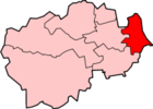
Lage in DurhamStatus District Region North East England Verw.grafschaft Durham Verwaltungssitz Easington Fläche 144,56 km² (212.) Einwohner 94.700 (238.) ONS-Code 20UF Website - Gründung 1974 Auflösung 2009 Easington war ein District in der Grafschaft Durham in England. Verwaltungssitz war die Stadt Easington. Weitere bedeutende Orte waren Peterlee und Seaham.
Der Bezirk wurde am 1. April 1974 gebildet und entstand aus der Fusion des Urban District Seaham und des Rural District Easington. Mit 1,2 % hat Easington landesweit den geringsten Anteil von Einwohnern, die außerhalb Großbritanniens geboren wurden. Am 1. April 2009 wurden neben Easington alle Dictricts im County Durham im Zuge der Verwaltungsreform abgeschafft und zur Unitary Authority Durham zusammengefasst.
Kategorien:- Ehemaliger District (North East England)
- County Durham

Wikimedia Foundation.