- East Hertfordshire
-
East Hertfordshire District 
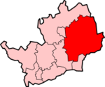
Lage in HertfordshireStatus District Region East of England Verw.grafschaft Hertfordshire Verwaltungssitz Bishop’s Stortford Fläche 475,69 km² (105.) Einwohner 134.000 (138.) ONS-Code 26UD Website www.eastherts.gov.uk East Hertfordshire ist ein District in der Grafschaft Hertfordshire in England. Verwaltungssitz ist Bishop’s Stortford; weitere bedeutende Orte sind Hertford (der traditionelle Verwaltungssitz der Grafschaft), Buntingford, Sawbridgeworth und Ware.
Der Bezirk wurde am 1. April 1974 gebildet und entstand aus der Fusion des Municipal Borough Hertford, der Urban Districts Bishop's Stortford, Sawbridgeworth und Ware sowie der Rural Districts Braughing, Ware und Hertford.
Broxbourne | Dacorum | East Hertfordshire | Hertsmere | North Hertfordshire | St Albans | Stevenage | Three Rivers | Watford | Welwyn Hatfield
Wikimedia Foundation.
Schlagen Sie auch in anderen Wörterbüchern nach:
East Hertfordshire — District Non metropolitan district East Hertfordshire shown within Hertfordshire … Wikipedia
East Hertfordshire — ▪ district, England, United Kingdom district, administrative and historic county of Hertfordshire, southeastern England, at the northern edge of the Greater London Green Belt. East Hertfordshire district is largely undulating and… … Universalium
East Hertfordshire District Council — is the local authority for the East Hertfordshire non metropolitan district of England, the United Kingdom. East Hertfordshire covers most of the eastern third of Hertfordshire, in the East of England region. The Council itself is based in Bishop … Wikipedia
East Hertfordshire local elections — East Hertfordshire Council is elected every four years.Political controlNo overall control 1973 1976Conservative 1976 1995No overall control 1995 1999Conservative 1999 presentCouncil electionsEast Hertfordshire Council election, 1999East… … Wikipedia
East Hertfordshire (UK Parliament constituency) — For the constituency alternatively called East Hertfordshire between 1885 and 1918, see Hertford UK former constituency infobox Name = East Hertfordshire Type = Borough Year = 1955 Abolition = 1983 members = oneEast Hertfordshire was a… … Wikipedia
North East Hertfordshire (UK Parliament constituency) — North East Hertfordshire County constituency for the House of Commons Boundary of North East Hertfordshire in … Wikipedia
Hertfordshire — Geografie Status: Zeremonielle und Verwaltungsgrafschaft Region: East of England Fläche … Deutsch Wikipedia
Hertfordshire County Council — is the upper tier local authority for the non metropolitan county of Hertfordshire, in England, the United Kingdom. It currently consists of 77 councillors, and is controlled by the Conservative Party, which has 46 councillors, versus 16 Labour… … Wikipedia
Hertfordshire — Not to be confused with Herefordshire. Hertfordshire Flag of Hertfordshire Motto of County Council: Trust and fear not … Wikipedia
Hertfordshire Chain Walk — Infobox Hiking trail Name=Hertfordshire Chain Walk Photo= Caption= Location= Hertfordshire, England Designation= Length=Convert|87|mi|0 Start/End Points= Use=Hiking ElevChange= HighPoint= LowPoint= Difficulty= Season=All year Sights= Hazards=The… … Wikipedia
