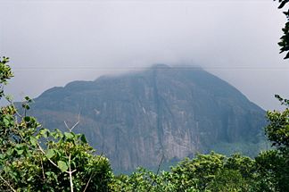
Agastya Malai

Agastya Malai
Agastya Malai
Der Agastya Malai

Der Agastya Malai

Höhe 1.868 m
Lage indischer Bundesstaat Kerala
Gebirge Westghats
Geographische Lage 8° 37′ 0″ N, 77° 15′ 0″ O8.616666666666777.251868Koordinaten: 8° 37′ 0″ N, 77° 15′ 0″ O
Agastya Malai (Kerala)
Agastya Malai

Der Agastya Malai ist ein 1.868 Meter hoher Gipfel in den südlichen Westghats, einem Gebirge in Indien. Der Berg liegt auf der Grenze zwischen den beiden indischen Bundesstaaten Kerala und Tamil Nadu. Der Agastya Malai ist ein Pilgerzentrum für Hindus, und wurde nach dem Weisen Agastya benannt, de sich auf dem Berge niederliess.


Wikimedia Foundation.

Игры ⚽ Поможем решить контрольную работу

Schlagen Sie auch in anderen Wörterbüchern nach:

  • Agastya — oder Agasti (Sanskrit: अगस्त्य Agastya m.; Tamil: Akattiyan) war ein vedischer mythischer Seher, der in Südindien als Kultheros verehrt wird. Ihm werden viele Wundertaten zugeschrieben und war ein Helfer der Götter und schlichtete auch den Streit …   Deutsch Wikipedia

  • Agastya Mala — Infobox Mountain Name = Agastya Mala Photo = AgasthyarkoodamPeak.jpg Caption = A view of Agastya Mala from the base Elevation = convert|1868|m|ft|0 Location = Tirunelveli, India Range = Western Ghats Prominence = Coordinates =… …   Wikipedia

  • Thamirabarani River — The Thamirabarani River (also spelt Tamaraparani and Tamiraparani) originates from a peak in hills of the Western Ghats above Papanasam in the Ambasamudram taluk and flows through the Tirunelveli Tuticorin district of the Tamil Nadu state of… …   Wikipedia

  • Kallana — Kani tribals dwelling in the rainforests of the Western Ghats (Kerala, India) claim that there are two distinct varieties of elephants in the Peppara forest range, one the common Indian elephants, and the other a dwarf variety which they call… …   Wikipedia

  • Kalakkad Mundanthurai Tiger Reserve — Infobox Indian Jurisdiction native name=Kalakkad Mundanthurai Tiger Reserve other name = type= Habitat/Species Management Area iucn category = IV latd = 8.65 |longd= 77.375 locator position=right inset inset map size = 75px inset map x = 175px… …   Wikipedia

  • Karamana — Vorlage:Infobox Fluss/KARTE fehlt DatenVorlage:Infobox Fluss/ …   Deutsch Wikipedia

  • Thiruvananthapuram (Distrikt) — Distrikt Thiruvananthapuram Bundesstaat: Kerala Verwaltungssitz: Thiruvananthapuram …   Deutsch Wikipedia

  • Pothigai — The Pothigai Malai (hill), also known as the Agasthiyar Malai, is in the Ashambu hills, part of the Annamalai Hills in the Western Ghats of Southern India. Legend says that Sage Agastya (also written as Agasthiyar or Agathiyar) created the Tamil… …   Wikipedia

  • Hanuman — This article is about the divine entity in Hinduism. For other uses, see Hanuman (disambiguation). Bajrangbali redirects here. For the movie, see Bajrangbali (film). Hanuman Depiction of Hanuman Chola Dynasty, 11th Century …   Wikipedia

  • Thoothukudi — Infobox Indian Jurisdiction native name=Tuticorin latd = 8.81 |longd = 78.14 state name=Tamil Nadu district= Thoothukudi leader title=District Collector leader name=Dr. R.Palaniyandi I.A.S. altitude= population as of = 2001 | population total =… …   Wikipedia

Share the article and excerpts

Direct link
Do a right-click on the link above
and select “Copy Link”