- Emalahleni
-
Emalahleni
Emalahleni Local Municipality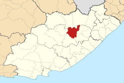
Basisdaten Staat Südafrika Provinz Ostkap Distrikt Chris Hani Sitz Lady Frere Fläche 3.551 km² Einwohner 125.291 (24. Oktober 2007) Dichte 35,3 Einwohner pro km² Schlüssel EC136 ISO 3166-2 ZA-EC Webauftritt www.emalahleni.gov.za (englisch) Politik Bürgermeister Salome Sithole Emalahleni ist eine Gemeinde des Distrikts Chris Hani, Provinz Ostkap in Südafrika. Auf einer Fläche von 3.550 km² leben etwa 125.000 Einwohner (Stand 2007). Sitz der Gemeindeverwaltung ist Lady Frere.[1]
Der Gemeindename ist das isiXhosa-, isiZulu- und isiNdebele-Wort für Kohle. [2]
Städte/Orte
- Dordrecht
- Indwe
- Lady Frere
- Lakishi
Weblinks
Einzelnachweise
Gemeinden des Distriktes Chris HaniEmalahleni | Engcobo | Inkwanca | Intsika Yethu | Inxuba Yethemba | Lukhanji | Sakhisizwe | Tsolwana
Wikimedia Foundation.
Schlagen Sie auch in anderen Wörterbüchern nach:
eMalahleni — eMalahleni … Deutsch Wikipedia
Emalahleni (Begriffsklärung) — Emalahleni (auch eMalahleni) steht für: Emalahleni, eine Gemeinde in der südafrikanischen Provinz Ostkap Emalahleni (Gemeinde), eine Gemeinde in der südafrikanischen Provinz Mpumlalanga Emalahleni (Ostkap), ein Ort in der südafrikanischen Provinz … Deutsch Wikipedia
Emalahleni Local Municipality, Mpumalanga — The Emalahleni Local Municipality is a municipality of South Africa, located in the Nkangala District Municipality, Mpumalanga. According to the 2001 Census it has a population of 190,885. Of these, 81.7% were African, 16.6% White, 1.4% Coloured… … Wikipedia
Witbank — Infobox Settlement official name = Witbank native name = nickname = settlement type = motto = imagesize = image caption = Aerial view over the suburbs flag size = image seal size = image shield = shield size = city logo = citylogo size = mapsize … Wikipedia
Chris Hani District Municipality — District municipality … Wikipedia
Liste der Gemeinden Südafrikas — Dies ist eine Liste der südafrikanischen Gemeinden. Inhaltsverzeichnis 1 Metropolgemeinden 2 Freistaat 2.1 Xhariep – Xhariep District Municipality (DC16) 2.2 … Deutsch Wikipedia
Liste der Städte in Südafrika — Die Liste der Städte in Südafrika bietet einen Überblick über die Entwicklung der Einwohnerzahl der größeren Städte und Gemeinden des Staates Südafrika. Inhaltsverzeichnis 1 Metropolregionen nach Einwohnerzahl 2 Städtische Siedlungen nach… … Deutsch Wikipedia
Witbank — DEC … Deutsch Wikipedia
Nkangala District Municipality — A map of Mpumalanga showing the Nkangala district Nkangala is one of the 3 districts of Mpumalanga province of South Africa. The seat of Nkangala is Middelburg. The Nkangala District Municipality consists of 160 towns and villages. The most… … Wikipedia
Duvha Power Station — Duvha Power Station … Wikipedia
Emalahleni

18+
© Academic, 2000-2026
- Kontaktieren Sie uns: Unterstützung, Werbung
Wörterbücher Export, schritte mit PHP, Joomla, Drupal, WordPress, MODx.