Enterprise Hills

Enterprise Hills

p1f1p4

Enterprise Hills
Höchster Gipfel Linder Peak (2.010 m)
Teil der Heritage Range
Enterprise Hills (Antarktis)
Enterprise Hills
Koordinaten 79° 55′ S, 82° 0′ W-79.916-822010Koordinaten: 79° 55′ S, 82° 0′ W
Die Enterprise Hills finden sich am unteren Kartenrand

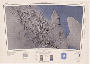
Die Enterprise Hills sind eine Gruppe weitgehend eisfreier Gipfel im Ellsworthgebirge in der Westantarktis. Sie sind Teil des Heritage Range, erstrecken sich in Form eines weiten Bogens über rund 45 km. Sie bilden den Nord- und Nordostrand des Horseshoe Valley und sind durch den Union Glacier von den Edson Hills im Nordwesten und den Collier Hills im Norden getrennt. Der Höchste Gipfel ist der Linder Peak mit 2.010 m. Der Nordwestrand der Enterprise Hills ist der Steilhang Rhodes Bluff.

Weitere Berge und Gipfel der Enterprise Hills sind:

Quelle


Wikimedia Foundation.

Игры ⚽ Нужно решить контрольную?

Schlagen Sie auch in anderen Wörterbüchern nach:

  • Liberty Hills (Antarktis) — 80.1 82.966666666667 Koordinaten: 80° 6′ S, 82° 58′ W …   Deutsch Wikipedia

  • Meyer Hills — 79.7833333 81.1 Koordinaten: 79° 47′ S, 81° 6′ W …   Deutsch Wikipedia

  • Meyer Hills — (79°47′S 81°6′W / 79.783°S 81.1°W / 79.783; 81.1) is a small group of hills located between the Enterprise Hills and the head of Constellation Inlet, in the Heritage Range …   Wikipedia

  • Brockworth Enterprise School — Infobox UK school name = Brockworth Enterprise School size = latitude = 51.84819 longitude = 2.14880 dms = dms motto = Learning for Success motto pl = established = 1967 approx = closed = c approx = type = religion = president = head label =… …   Wikipedia

  • Coachella Valley Enterprise Zone — The Coachella Valley Enterprise Zone Authority (CVEZA) established in 1992 is one of 42 zone authorities competitively designated for 15 years by the State of California. Each enterprise zone promotes, explains, supports, and administers business …   Wikipedia

  • Waseley Hills High School and Sixth Form Centre — Infobox UK school name = Waseley Hills High School and Sixth Form Centre size = latitude = 52.39136 longitude = 2.03123 dms = dms motto = motto pl = established = approx = closed = c approx = type = religion = president = head label = Headteacher …   Wikipedia

  • Blackdown Hills — Geobox Protected Area name = Blackdown Hills native name = other name = other name1 = category local = Area of Outstanding Natural Beauty category iucn = image size = image caption = Blackdown Hills AONB near Dalwood, Devon country = England… …   Wikipedia

  • Para Hills, South Australia — Infobox Australian Place | type = suburb name = Para Hills state = sa city = Adelaide caption = A gully next to Para Hills primary school area = 3.21 lga = City of Salisbury lga2 = City of Tea Tree Gully postcode = 5096 pop = 7,722 [Census 2006… …   Wikipedia

  • Laguna Hills High School — Infobox School name=Laguna Hills High School type=Public location=25401 Paseo de Valencia Laguna Hills, CA information=(949) 770 5447 established=1978 grades=9 12 enrollment=1,818 faculty=80 principal=Sean Boulton mascot=Hawk… …   Wikipedia

  • Carla Anderson Hills — (* 3. Januar 1934 in Los Angeles, Kalifornien) ist eine US amerikanische Hochschullehrerin, Politikerin und Managerin …   Deutsch Wikipedia

Share the article and excerpts

Direct link
Do a right-click on the link above
and select “Copy Link”