Fajã de Agua

Fajã de Agua
Das Tal Fajã de Água
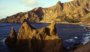
Bucht von Fajã und im Hintergrund der Ort Fajã de Água
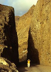
Straße zum Flugplatz

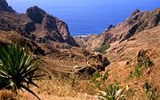
Fajã de Água ist ein Tal und Ort im Westen der Insel Brava, der westlichsten der Sotavento-Inseln (Inseln Unter dem Wind) auf Kap Verde.

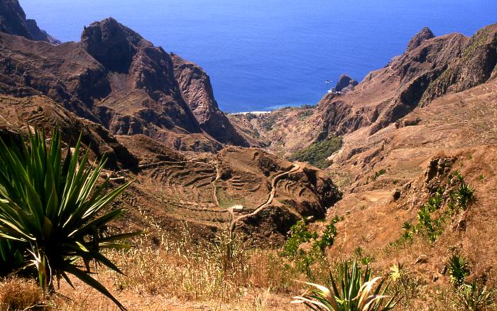
Das eindrucksvolle Tal beginnt auf 450 m Höhe auf einen Plateau mit zahlreichen Bauernhöfen und ist das fruchtbarste auf Brava mit Kokospalmen, Zuckerrohr, Bananen und Gemüseanbau auf bewässerten Terrassen mit den typischen Steinmäuerchen und endet am Meer in einer geschützten Bucht, der Bucht von Fajã. Hier, an einer der wohl schönsten Buchten Kap Verdes gingen einst die Walfänger vor Anker.

An der von Vila Nova Sintra herabkommenden und am Strand entlangführenden Straße befindet sich eine Häuserzeile mit Motel, Kirche und Einkaufsmöglichkeiten. Die Straße mit einem beachtlichen Felseinschnitt endet am Flugplatz. Straße und Flugplatz wurden von der einheimischen vorwiegend arbeitslosen Bevölkerung als food-for-work-Maßnahme mit deutschen Entwicklungshilfegeldern gebaut und 1989 fertiggestellt.

Der Flugplatz von Brava wurde inzwischen stillgelegt.

14.866666666667-24.757Koordinaten: 14° 52′ N, 24° 45′ W


Wikimedia Foundation.

Игры ⚽ Поможем сделать НИР

Schlagen Sie auch in anderen Wörterbüchern nach:

  • Fajã de Água — Fajã de Água …   Deutsch Wikipedia

  • Fajã de Agua — (in Cape Verdean Creole, written in ALUPEC: Fajan di Água ), is a community in the northwestern part of the island of Brava, Cape Verde. The area around Furna is surrounded by mountains to the east and the south with a small valley within the… …   Wikipedia

  • Agua potable y saneamiento en Uruguay — Uruguay: Agua y Saneamiento Datos Cobertura del agua potable (definición amplia) 97% Cobertura del alcantarillado (definición amplia) Continuidad de servicio(%) …   Wikipedia Español

  • faja de prado — es un campo o faja de tierra en pendiente, cubierta de pasto o hierba que hace las veces de un canal ancho y poco profundo para el agua en tiempos de escurrimiento …   Diccionario ecologico

  • Brava — Karte der Insel Gewässer Atlantischer Ozean Inselgruppe …   Deutsch Wikipedia

  • Cova Joana — Kova Juana Statistics Island: Brava Municipality: Brava Distance from the island capital: about 2 to 3 km south Vila Nova Sintra …   Wikipedia

  • List of villages and settlements in Cape Verde — This is a list of villages and settlements in Cape Verde:Boa Vista*Bafureira *Cabeço do Tarafes *Curral Velho *Estancia de Baixo *Funda das Figueiras *Gata *João Barreiro *João Galego *Norte *Povoação Velha *Santo TirsoBrava*Cachaço *Campo Baixo… …   Wikipedia

  • Brava, Cape Verde — Geobox|Island name = Brava country = Cape Verde country highest location = Monte Fontainhas highest elevation = 976 coordinates type = isle lat d = 14 |lat m = 52 |lat NS = N long d = 24 |long m = 42 |long EW = W area = 67 length = 24 length… …   Wikipedia

  • Mato Grande — Statistics Island: Brava Municipality: Brava Distance from the island capital: near Vila Nova Sintra Mato Grande …   Wikipedia

  • List of ports in Cape Verde — This article is a list of ports and harbors (or harbours) in Cape Verde. Several of its major ports are owned by the Capeverdean porta authority, ENAPOR:Major and minor ports =Boa Vista= *Sal Rei =Brava= *Fajã da Agua *Furna =Fogo= *Cova Figueira …   Wikipedia

Share the article and excerpts

Direct link
Do a right-click on the link above
and select “Copy Link”