- Akun Island
-
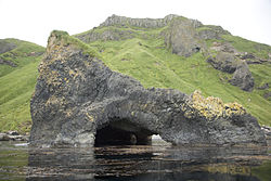
Akun Basalt-Höhle an der Küste von Akun Island Gewässer Pazifischer Ozean Inselgruppe Aleuten Geographische Lage 54° 12′ N, 165° 34′ W54.198055555556-165.57083333333818Koordinaten: 54° 12′ N, 165° 34′ W Länge 23 km Breite 16 km Fläche 65 km² Höchste Erhebung 818 m Einwohner (unbewohnt) Akun (aleutisch:Akungan) ist eine unbewohnte Insel der Krenitzin Islands und gehört zu den Aleuten. Die ca. 65 km² große Insel liegt östlich von Akutan und südwestlich von Unimak. Markanteste Erhebung der 23 km langen und 16 km breiten Insel ist der erloschene Vulkan St. Gilbert (818 m).
1928 wurde die Insel durch eine spektakuläre Rettungsaktion der amerikanischen Küstenwache bekannt. Diese rettete alle Passagiere und Besatzungsmitglieder des Seglers Falkland Star, der in dichtem Nebel an der Küste Schiffbruch erlitten hatte.
Heute sind auf der Insel verwilderte Kühe heimisch.
Weblinks
 Commons: Akun Island – Sammlung von Bildern, Videos und Audiodateien
Schlagen Sie auch in anderen Wörterbüchern nach:
Akun Island — Location map Alaska label= lat=54.397958 long= 165.420831 position=right width=250 float=right caption=Location in AlaskaAkun Island (Akungan [Bergsland, K Aleut Dictionary Fairbanks: Alaska Native Language Center, 1994] in Aleut) is one of the… … Wikipedia
Akun Island — Sp Akūno salà Ap Akun Island L Aleutuose, Lapių ss., JAV (Aliaska) … Pasaulio vietovardžiai. Internetinė duomenų bazė
Avatanak Island — Vorlage:Infobox Insel/Wartung/Bild fehltVorlage:Infobox Insel/Wartung/Fläche fehlt Avatanak Island Gewässer Pazifischer Ozean Inselgruppe Aleuten Geographische Lage … Deutsch Wikipedia
Avatanak Island — Location map Alaska label= lat=54.071667 long= 165.603889 position=right width=250 float=right caption=Location in AlaskaAvatanak Island (Agutanax̂ [Bergsland, K Aleut Dictionary Fairbanks: Alaska Native Language Center, 1994] in Aleut) is the… … Wikipedia
USCGC Staten Island (WAGB-278) — was a United States Coast Guard Wind class icebreaker. The Staten Island is actually the original Northwind ; the original Northwind was transferred to the Soviet Union under the Lend Lease program in 1944 almost immediately after being… … Wikipedia
Poa Island — Vorlage:Infobox Insel/Wartung/Bild fehltVorlage:Infobox Insel/Wartung/Fläche fehltVorlage:Infobox Insel/Wartung/Höhe fehlt Poa Island Gewässer Pazifischer Ozean Inselgruppe Aleuten … Deutsch Wikipedia
Tangik Island — Vorlage:Infobox Insel/Wartung/Bild fehltVorlage:Infobox Insel/Wartung/Fläche fehltVorlage:Infobox Insel/Wartung/Höhe fehlt Tangik Island Gewässer Pazifischer Ozean Inselgruppe Aleuten … Deutsch Wikipedia
Tanginak Island — Vorlage:Infobox Insel/Wartung/Bild fehltVorlage:Infobox Insel/Wartung/Fläche fehltVorlage:Infobox Insel/Wartung/Höhe fehlt Tanginak Island Gewässer Pazifischer Ozean Inselgruppe Aleuten … Deutsch Wikipedia
Poa Island — (Saduuĝinax̂ [Bergsland, K Aleut Dictionary Fairbanks: Alaska Native Language Center, 1994] in Aleut) (54°07 38 N 165°29 58 ) is an island in the Fox Islands group of the eastern Aleutian Islands, Alaska. It is 0.7 miles long and is located 1… … Wikipedia
Akutan Island — Akutan NASA Bild von Mount Akutan Gewässer Pazifischer Ozean … Deutsch Wikipedia


