- Forsyth (Montana)
-
Forsyth 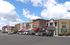
Downtown ForsythLage in Montana 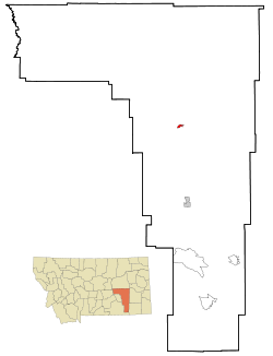
Basisdaten Staat: Vereinigte Staaten Bundesstaat: Montana County: Koordinaten: 46° 16′ N, 106° 41′ W46.266666666667-106.67777777778769Koordinaten: 46° 16′ N, 106° 41′ W Zeitzone: Mountain Standard Time (UTC−7) Einwohner: 1944 (Stand: 2000) Bevölkerungsdichte: 670,3 Einwohner je km² Fläche: 2,9 km² (ca. 1 mi²) Höhe: 769 m Postleitzahl: 59327 Vorwahl: +1 406 FIPS: 30-27700 GNIS-ID: 0771501 Webpräsenz: www.forsythmontana.org 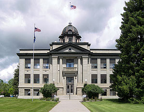
Rosebud County CourthouseForsyth ist eine Stadt im Rosebud County, Montana, in den Vereinigten Staaten von Amerika. Zu den Zählungen im Jahr 2000 hatte sie 1.944 Einwohner. Sie ist Sitz der Countyverwaltung (County Seat) von Rosebud County.
Geographie
Forsyth befindet sich bei den Koordinaten 46° 16′ N, 106° 41′ W46.266666666667-106.67777777778.
Nach Angaben des United States Census Bureau erstreckt sich die Stadt auf einer Fläche von 2,9 km², auf der es keine Wasserflächen gibt.
Demographie
Laut der Zählung im Jahr 2000 leben 1944 Menschen in der Stadt. Diese verteilen sich auf insgesamt 826 Haushalte und 525 Familien. Die Bevölkerungsdichte beträgt 676,2 Menschen pro km². Die ethnischen Zugehörigkeiten sind folgendermaßen gestaffelt: 95,42% Weiße; 2,26% Amerikanische Ureinwohner; 1,23 Lateinamerikaner oder Hispanics; 0,82 Asiaten; 0,21% Afroamerikaner. Der Rest gehört anderen Minderheiten an oder ist gemischtrassig.
Es gibt 826 Haushalte, von denen in 29,8% Kinder unter 18 Jahren, in 52,7% Verheiratete Paare, in 7,4% alleinstehende Frauen und in 36,4% Menschen ohne Familie leben. In 14,4% der Haushalte leben Personen, die älter als 65 Jahre sind. Die durchschnittliche Anzahl von Personen in einem Haushalt beträgt 2,28, in Familien 2,89.
Der Altersaufbau der Stadt ist folgendermaßen gestaffelt: 25,1% unter 18 Jahren; 5,4% zwischen 18 und 24 Jahren; 25,2% zwischen 25 und 44 Jahren; 27,0% zwischen 45 und 64 Jahren; 17,4% Über 64 Jahre
Das Einkommen pro Haushalt beträgt im Mittel 33.533$, das von Familien 44.100$. 9,4% der Familien und 10,5% der gesamten Bevölkerung leben unterhalb der Armutsgrenze.
Kategorien:- Ort in Montana
- County Seat in Montana


Wikimedia Foundation.