Geluveld

Geluveld
Geluveld
Geluveld (Belgien)
Geluveld
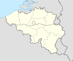
Geluveld
Staat Belgien
Region Flandern
Provinz Westflandern
Bezirk Ypern
Koordinaten 50° 52′ N, 3° 0′ O50.8672222222222.9938888888889Koordinaten: 50° 52′ N, 3° 0′ O
Fläche 7,79 km²
Einwohner (Stand) 1.501 Einw. (31. Dezember 2006)
Bevölkerungsdichte 193 Einw./km²
Postleitzahl 8980
Vorwahl 051 & 057
Adresse der
Stadtverwaltung
Gemeentehuis
Langemarkstraat 8
8980 Zonnebeke
Webseite www.zonnebeke.be

lwlflblhlb

Geluveld (auch:Gheluvelt) ist ein Dorf in der belgischen Gemeinde Zonnebeke. Der Ort hat ca. 1.500 Einwohner (2006) und liegt einige Kilometer südlich des Hauptortes an der N8 und A19. Der Weg führt hier nach Ypern.

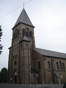
St-Margareta Kirche Gebaut in Neoromanischen Stil 1924

Geschichte

Der Ort wurde erstmal 1109 als Gelevelt erwähnt.

Seine Lage auf dem Weg nach Ypern machten den Ort ab dem 29. Oktober 1914 zum Schlachtfeld (Erste Flandernschlacht). Nach schweren Kämpfen wurde der Ort von den Deutschen erobert und erst am 28. September 1918 aufgegeben. Der Ort wurde bei den Kämpfen völlig zerstört.

Weblinks


Wikimedia Foundation.

Игры ⚽ Нужна курсовая?

Schlagen Sie auch in anderen Wörterbüchern nach:

  • Geluveld — Geluveld …   Wikipédia en Français

  • Gheluvelt — Geluveld DEC …   Deutsch Wikipedia

  • Bataille De Passchendaele — 50°54′1″N 3°1′16″E / 50.90028, 3.02111 …   Wikipédia en Français

  • Bataille de Paschendale — Bataille de Passchendaele 50°54′1″N 3°1′16″E / 50.90028, 3.02111 …   Wikipédia en Français

  • Bataille de Passchendaele — Pour les articles homonymes, voir Bataille d Ypres. 50°54′1″N 3°1′16″E / …   Wikipédia en Français

  • Bataille de passchendaele — 50°54′1″N 3°1′16″E / 50.90028, 3.02111 …   Wikipédia en Français

  • Paschendale — Bataille de Passchendaele 50°54′1″N 3°1′16″E / 50.90028, 3.02111 …   Wikipédia en Français

  • Zonnebeke — Géolocalisation sur la carte : Belgique …   Wikipédia en Français

  • Zonnebeke — Infobox Belgium Municipality name=Zonnebeke picture= picture map arms=Zonnebeke wapen.jpg region=BE REG FLE community=BE NL province=BE PROV WV arrondissement=Ypres nis=33037 pyramid date=01/01/2006 0 19=24.13 20 64=57.94 65=17.93 foreigners=0.91 …   Wikipedia

  • List of postal codes in Belgium — Belgian postal codes are numeric and consist of 4 numbers, although the last one is often zero. The first digit indicates the province (except for the 3xxx numbers that are shared by the eastern part of Flemish Brabant and Limburg and the and… …   Wikipedia

Share the article and excerpts

Direct link
Do a right-click on the link above
and select “Copy Link”