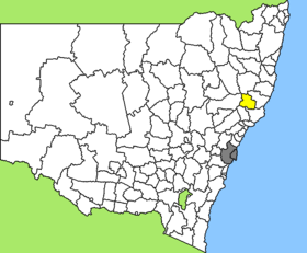
Gloucester Shire

Gloucester Shire
Shire of Gloucester
Australia-Map-NSW-LGA-Gloucester.png
Lage des Gloucester Shire in New South Wales
Gliederung
Staat: Australien Australien
Bundesstaat: Flag of New South Wales.svg New South Wales
Verwaltungssitz: Gloucester
Daten und Zahlen
Fläche: 2.952 km²
Einwohner: 4.802 (2006) [1]
Bevölkerungsdichte: 1,6 Einwohner je km²
-32151.96666666667

Gloucester Shire ist ein lokales Verwaltungsgebiet (LGA) im australischen Bundesstaat New South Wales. Das Gebiet ist 2.952 km² groß und hat etwa 4.800 Einwohner.

Gloucester liegt im Norden der Hunter-Region nahe der Ostküste etwa 260 km nördlich der Metropole Sydney. Das Gebiet umfasst 66 Ortsteile und Ortschaften, darunter Barrington, Cobark, Copeland, Gloucester, Rawdon Vale, Rookhurst, Stratford, Upper Bowman und Teile von Bundook und Craven. Der Sitz des Shire Councils befindet sich in Gloucester, wo etwa 2.400 Einwohner leben.

Verwaltung

Der Gloucester Shire Council hat neun Mitglieder, die von den Bewohnern der LGA gewählt werden. Gloucester ist nicht in Bezirke untergliedert. Aus dem Kreis der Councillor rekrutiert sich auch der Mayor (Bürgermeister) des Councils.

Weblinks

Einzelnachweise

  1. Australian Bureau of Statistics (25. Oktober 2007): Gloucester (A) (Local Government Area) (Englisch). 2006 Census QuickStats. Abgerufen am 6. April 2010.

Wikimedia Foundation.

Игры ⚽ Нужна курсовая?

Schlagen Sie auch in anderen Wörterbüchern nach:

  • Gloucester Shire — Infobox Australian Place | type = lga name = Gloucester Shire Council state = NSW caption = Location in NSW pop = 4,683 Census 2001 AUS|id=LGA13050|name=Gloucester (A) (Local Government Area|accessdate = 2006 11 22|quick=on] area = 2952 est =… …   Wikipedia

  • Gloucester Shire — Admin ASC 2 Code Orig. name Gloucester Shire Country and Admin Code AU.02.13050 AU …   World countries Adminstrative division ASC I-II

  • Gloucester, New South Wales — Infobox Australian Place | type = town name = Gloucester state = nsw caption = The Gloucester River commences in the Barrington Mountains (3000 feet). lga = Gloucester Shire postcode = est = 1855 pop = 3000 elevation= maxtemp = mintemp = rainfall …   Wikipedia

  • Gloucester [1] — Gloucester (Glocester, spr. Gloster), 1) (Gloucestershire), Grafschaft im südwestlichen England, mit dem Titel eines Herzogthums, 59,38 QM.; grenzt an Hereford, Worcestershire, Warwickshire, Oxfordshire, Wiltshire, Somersetshire u. Monmuthshire;… …   Pierer's Universal-Lexikon

  • Gloucester — This article is about the city in England; for other uses see Gloucester (disambiguation). City of Gloucester   City Non metropolitan district   …   Wikipedia

  • Gloucester County, Virginia — Infobox U.S. County county = Gloucester County state = Virginia map size = 225 founded = 1651 seat = Gloucester Courthouse | area total sq mi =288 area water sq mi =71 area percentage = 24.79% census yr = 2000 pop = 34780 density km2 =62 web =… …   Wikipedia

  • Gloucester — City of Gloucester Koordinaten …   Deutsch Wikipedia

  • Gloucester Tree — The Gloucester Tree is a giant karri tree in the Gloucester National Park of Western Australia. At 61 metres (201 feet) in height, it is the world s tallest fire lookout tree, and visitors can climb up to a platform in its upper branches for a… …   Wikipedia

  • Gloucester Tree — Erklettern des Gloucester Tree …   Deutsch Wikipedia

  • Gloucester — I. /ˈglɒstə/ (say glostuh) noun Prince Henry William Frederick Albert, Duke of (Earl of Ulster, Baron Culloden), 1900–74, son of George V, governor general of Australia 1945–47, born in England. II. /ˈglɒstə/ (say glostuh) noun 1. a city in south …  

Share the article and excerpts

Direct link
Do a right-click on the link above
and select “Copy Link”