Goulburn Mulwaree Council

Goulburn Mulwaree Council
Australia-Map-NSW-LGA-GoulburnMulwaree.png
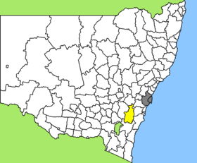
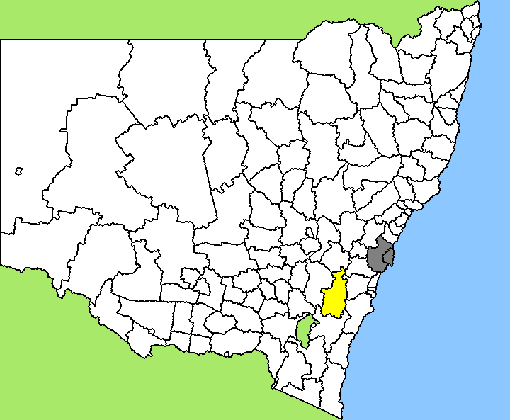
Lage des Goulburn Mulwaree Council in New South Wales
Gliederung
Staat: Australien Australien
Bundesstaat: Flag of New South Wales.svg New South Wales
Verwaltungssitz: Goulburn
Daten und Zahlen
Fläche: 3.220 km²
Einwohner: 26.086 (2006) [1]
Bevölkerungsdichte: 8,1 Einwohner je km²
-34.733333333333149.73333333333

Goulburn Mulwaree Council ist ein lokales Verwaltungsgebiet (LGA) im australischen Bundesstaat New South Wales. Das Gebiet ist 3.220 km² groß und hat etwa 26.000 Einwohner. Beim Zusammenschluss der alten LGA Goulburn City mit Teilen des Mulwaree Shire 2004 hieß das Gebiet noch Greater Argyle, bekam aber im Jahr darauf nach Protesten seinen heutigen Namen.

Goulburn Mulwaree liegt in der Südostregion des Staates etwa 95 km nordöstlich der australischen Hauptstadt Canberra und 190 km südwestlich der Metropole Sydney. Das Gebiet umfasst 42 Ortsteile und Ortschaften, darunter Argyle, Bungonia, Goulburn, Lake Bathurst, Kenmore, Komungla, Marulan, Tallong, Tirrannaville, Towrang, Windellama, Yarra und ein Teil von Tarago. Der Sitz des Shire Councils befindet sich in der Nordhälfte der LGA in Goulburn, das etwa 20.000 Einwohner hat.

Verwaltung

Der Council von Goulburn Mulwaree hat neun Mitglieder, die von den Bewohnern der LGA gewählt werden. Goulburn Mulwaree ist nicht in Bezirke untergliedert. Aus dem Kreis der Councillor rekrutiert sich auch der Mayor (Bürgermeister) des Councils.

Weblinks

Einzelnachweise

  1. Australian Bureau of Statistics (25. Oktober 2007): Goulburn Mulwaree (A) (Local Government Area) (Englisch). 2006 Census QuickStats. Abgerufen am 6. April 2010.

Wikimedia Foundation.

Игры ⚽ Поможем написать курсовую

Schlagen Sie auch in anderen Wörterbüchern nach:

  • Goulburn Mulwaree Council — Infobox Australian Place | type = lga name = Goulburn Mulwaree state = nsw caption = Location in NSW pop = 27,112 cite web publisher = Australian Bureau of Statistics title=Regional Population Growth, Australia, 2004 05 url =… …   Wikipedia

  • Conseil de Goulburn Mulwaree — 34°44′S 149°44′E / 34.733, 149.733 …   Wikipédia en Français

  • Goulburn — Staat: Australien Bundesstaat …   Deutsch Wikipedia

  • Goulburn — Construcción en Goul …   Wikipedia Español

  • Goulburn, New South Wales — Infobox Australian Place | type = town name = Goulburn state = nsw caption = Landmark: The Big Merino lga = Goulburn Mulwaree Council county = Argyle postcode = 2580 pop = 20,127 (2006 Census) Fact|date=August 2008 est = 1833 elevation= 702… …   Wikipedia

  • Goulburn — Pour les articles homonymes, voir Goulburn (homonymie). Goulburn Le palais de justice de Goulb …   Wikipédia en Français

  • Goulburn Airport — Infobox Airport name = Goulburn Airport nativename = nativename a = nativename r = image width = caption = IATA = GUL ICAO = YGLB type = Public owner = operator = Goulburn Mulwaree Council city served = location = Goulburn elevation f = 2140… …   Wikipedia

  • Electoral district of Goulburn — Goulburn is an electoral district of the Legislative Assembly in the Australian state of New South Wales. It is represented by Pru Goward of the Liberal Party of Australia.The 2004 redistribution of electoral districts estimated that the… …   Wikipedia

  • Palerang Council — Infobox Australian Place | type = lga name = Palerang state = nsw caption = Location in NSW pop = 11,470 cite web publisher = Australian Bureau of Statistics title=Regional Population Growth, Australia, 2004 05 url =… …   Wikipedia

  • Marrickville Council — New South Wales Population: 78,271(2009) …   Wikipedia

Share the article and excerpts

Direct link
Do a right-click on the link above
and select “Copy Link”