- Great Chagos Bank
-
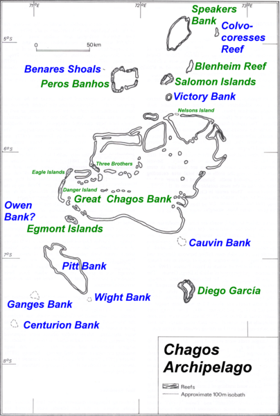
Great Chagos Bank Karte des Chagos-Archipels mit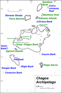
der Great Chagos BankGewässer Indischer Ozean Archipel Chagos-Archipel Geographische Lage 6° 10′ S, 72° 0′ O-6.166666666666772Koordinaten: 6° 10′ S, 72° 0′ O 

Anzahl der Inseln 7 Hauptinsel Île Aigle
(Eagle Island)Länge 150 km Breite 100 km Landfläche 4,5 km² Gesamtfläche 12.642 km² Einwohner (unbewohnt) Die Great Chagos Bank (dt. etwa Große Chagosbank) liegt genau in der Mitte des Chagos-Archipels. Es liegt ungefähr 500 km südlich der Malediven und ist mit 12.642 km² die größte zusammenhängende Atollgruppe weltweit. Die riesigen Lagune ist durchschnittlich 75 Meter tief; die Größte Tiefe beträgt 90 Meter.[1]
Die acht Inseln liegen am Rand des Atolls, eine im Norden (Nelsons Island) und die anderen am westlichen Rand. Die gesamte Landfläche beträgt 4,5 km². Die Great Chagos Bank gehört administrativ zum britischen Territorium im Indischen Ozean.
Die Inseln im Uhrzeigersinn, beginnend im Süden sind:
- Danger Island
- Eagle Islands (Îlles Aigle)
- Eagle Island (Île Aigle)
- Sea Cow Island (Île Vache Marine)
- Three Brothers (Trois Frères)
- South Island (Îlle du Sud)
- Middle Island (Îlle du Mileu)
- North Island (Îlle du Nord)
- Nelsons Island
Einzelnachweise
Kategorien:- Inselgruppe (Indischer Ozean)
- Inselgruppe (Britisches Territorium im Indischen Ozean)
- Inselgruppe ohne Kontinentalbezug
- Unbewohnte Inselgruppe
- Atoll

Wikimedia Foundation.