Hatsushima

Hatsushima

Vorlage:Infobox Insel/Wartung/Höhe fehlt

Hatsushima
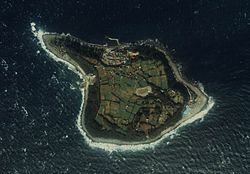
Hatsushima, Aufnahme des japanischen MLIT von 1983
Gewässer Sagami-Bucht
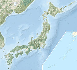
Geographische Lage 35° 2′ 23″ N, 139° 10′ 15″ O35.039722222222139.17083333333Koordinaten: 35° 2′ 23″ N, 139° 10′ 15″ O
Hatsushima (Japan)
Hatsushima
Länge 4 km
Fläche 0,44 km²
Einwohner 243 (2006)
552 Einw./km²

Die Insel Hatsushima (jap. 初島) liegt in der Sagami-Bucht, in der Präfektur Shizuoka. Sie ist mit einem Durchmesser von 4 km und einer Fläche von 44 Hektar nicht sehr groß, aber die einzige bewohnte Insel in der Präfektur. 2006 lebten 243 Personen auf ihr. Mit Schnellboot ist sie etwa 30 min von Atami, dem nächsten Festlandhafen entfernt, zu dem sie verwaltungstechnisch gehört. Die Insel ist touristisch voll erschlossen. Sie hat zwar keinen Sandstrand aber man kann die 4 km um die Insel auf erschlossenen Weg erwandern, als auch Tauchen, Fischen, usw.

Die Versorgung der Insel ist problematisch, so werden Strom und Wasser mittels einer unterirdischen Leitung von der Izu-Halbinsel geholt. Für die Bewohner gibt es kein Krankenhaus, im Notfall muss ein Helikopter kommen. Dafür gibt es eine Schule.

Die Insel beherbergt auch eine Außenstelle des Japan Agency for Marine-Earth Science Technologie (JAMSTEC) mit einem kleinen Museum.

Weblinks


Wikimedia Foundation.

Игры ⚽ Нужна курсовая?

Schlagen Sie auch in anderen Wörterbüchern nach:

  • Hatsushima Station — is a train station in Arida, Wakayama Prefecture, Japan.Lines*West Japan Railway Company (JR West) **Kisei Main LineLayoutAdjacent stations !colspan=5|West Japan Railway Company (JR West) ###@@@KEYEND@@@### …   Wikipedia

  • Minoshima Station — (箕島駅, Minoshima eki?) is a train station in Arida, Wakayama Prefecture, Japan. Lines West Japan Railway Company (JR West) Kisei Main Line Layout …   Wikipedia

  • Atami (Shizuoka) — Atami shi 熱海市 Geographische Lage in Japan …   Deutsch Wikipedia

  • Liste des îles du Japon — Voici la liste d îles du Japon. Le Japon est un archipel composé d environ 3 000 îles de tailles diverses, les quatre principales étant Honshū, Hokkaidō, Kyūshū et Shikoku. Toutes ne sont pas représentées ici. Sommaire 1 Par lieux 1.1 Mer du… …   Wikipédia en Français

  • Anzu — Infobox Given Name Revised name = Anzu imagesize= caption= pronunciation= gender = Female meaning = region = origin = Japanese related names = footnotes = Anzu is a Japanese given name for females. Anzu means Apricot in Japanese.;People *Anzu… …   Wikipedia

  • USS Sennet (SS-408) — USS Sennet (SS 408), a Balao class submarine, was a ship of the United States Navy named for the sennet, a barracuda. Sennet was laid down on 8 March 1944 by the Portsmouth Navy Yard in Kittery, Maine; launched on 6 June 1944, sponsored by Mrs.… …   Wikipedia

  • Operation Hailstone — Part of World War II, Pacific War …   Wikipedia

  • JMSDF Fleet — Guided Missile Destroyers (DDG)* Atago class destroyers (2 in service) **JS Ashigara **JDS Atago * JDS Kongō class destroyers (4 in service) **JDS Kongō **JDS Kirishima **JDS Myōkō **JDS Chōkai * Hatakaze class destroyers (2 in service) **JDS… …   Wikipedia

  • Miwasaki Station — (三輪崎, Miwasaki eki?) is a train station in Shingū, Wakayama Prefecture, Japan. Lines West Japan Railway Company (JR West) Kisei Main Line Layout …   Wikipedia

  • Nachi Station — (那智駅, Nachi eki?) is a train station in Nachikatsuura, Higashimuro District, Wakayama Prefecture, Japan. Lines West Japan Railway Company (JR West) Kisei Main Line Layout …   Wikipedia

Share the article and excerpts

Direct link
Do a right-click on the link above
and select “Copy Link”