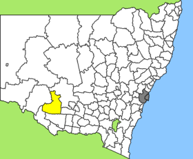
Hay Shire

Hay Shire
Shire of Hay
Australia-Map-NSW-LGA-Hay.png
Lage des Hay Shire in New South Wales
Gliederung
Staat: Australien Australien
Bundesstaat: Flag of New South Wales.svg New South Wales
Verwaltungssitz: Hay
Daten und Zahlen
Fläche: 11.328 km²
Einwohner: 3.383 (2006) [1]
Bevölkerungsdichte: 0,3 Einwohner je km²
-34.5144.85

Hay Shire ist ein lokales Verwaltungsgebiet (LGA) im australischen Bundesstaat New South Wales. Das Gebiet ist 1.896 km² groß und hat etwa 3.500 Einwohner.

Hay liegt im Südwesten des Staates an Murrumbidgee und Lachlan River etwa 720 km westlich der Metropole Sydney. Das Gebiet umfasst 24 Ortsteile und Ortschaften: Benarca, Benduck, Booligal, Burrabogie, Cobran, Eurolie, Eurugabah, Geramy, Hay, Hay Irrigation Area, Hay South, Hay West, Illilliwa, Maude, Nap Nap, Newmarket, Nulabor, One Tree, Pevensey, Ravensworth, Thelangerin, Toogimbie, Wyoming und ein Teil von Oxley. Der Sitz des Shire Councils befindet sich in Hay in der Südhälfte der LGA, wo etwa 2.600 Einwohner leben.

Verwaltung

Der Hay Shire Council hat acht Mitglieder, die von den Bewohnern der LGA gewählt werden. Hay ist nicht in Bezirke untergliedert. Aus dem Kreis der Councillor rekrutiert sich auch der Mayor (Bürgermeister) des Councils.

Weblinks

Einzelnachweise

  1. Australian Bureau of Statistics (25. Oktober 2007): Hay (A) (Local Government Area) (Englisch). 2006 Census QuickStats. Abgerufen am 6. April 2010.

Wikimedia Foundation.

Игры ⚽ Нужен реферат?

Schlagen Sie auch in anderen Wörterbüchern nach:

  • Hay Shire Council — Infobox Australian Place | type = lga name = Hay Shire state = nsw caption = Hay Shire Council office and chambers pop = 3,822 density = 0.34 area = 11325.89 area footnotes = [cite web|title = Hay Regional Profile | url =… …   Wikipedia

  • Hay, New South Wales — Infobox Australian Place | type = town name = Hay state = nsw caption = Westpac Bank building (previously A.J.S. Bank, built in 1877), corner of Lachlan Bank streets at Hay lga = Hay Shire Council postcode = 2711 pop = 2,692 (2001 Census) est =… …   Wikipedia

  • Hay — /hay/, n. John Milton, 1838 1905, U.S. statesman and author. * * * I In agriculture, dried grasses and other foliage used as animal feed. Typical hay crops are timothy, alfalfa, and clover. Usually the material is cut in the field while still… …   Universalium

  • Shire (Middle-earth) — For other uses, see Shire (disambiguation). The Shire Place from J. R. R. Tolkien s legendarium The fields of the Shire in the Lord of the Rings movie trilogy Other names …   Wikipedia

  • Shire (Caballo) — Este artículo o sección necesita una revisión de ortografía y gramática. Puedes colaborar editándolo (lee aquí sugerencias para mejorar tu ortografía). Cuando se haya corregido, borra este aviso por favor …   Wikipedia Español

  • Shire of Sarina — Infobox Australian Place | type = lga name = Shire of Sarina state = qld imagesize= 180 caption = Location within Queensland pop = 9,610 (2001 census) area = est = seat = Sarina region = url = http://www.sarina.qld.gov.au/ near nw = Mackay near n …   Wikipedia

  • hay — hayey, adj. /hay/, n. 1. grass, clover, alfalfa, etc., cut and dried for use as forage. 2. grass mowed or intended for mowing. 3. Slang. a. a small sum of money: Twenty dollars an hour for doing very little certainly ain t hay. b. money: A… …   Universalium

  • Hay Point, Queensland — Infobox Australian Place | type = town name = Hay Point state = qld caption = Coal loaders at Hays Point lga = Mackay Regional Council postcode = 4740 est = pop = 1,386 pop footnotes= elevation= maxtemp = mintemp = rainfall = stategov = Mirani… …   Wikipedia

  • Hay Gate —    The northern gate of the High Hay.    The North Gate of Buckland, that guarded the Eastmarch of the Shire from travellers on the East Road. It stood at the northern end of the Hedge known as the High Hay …   J.R.R. Tolkien's Middle-earth glossary

  • Hay — I. /heɪ/ (say hay) noun William Gosse, 1875–1945, Australian novelist; author of The Escape of the Notorious Sir William Heans (1919). II. /heɪ/ (say hay) noun 1. a river rising in the MacDonnell Ranges and flowing east towards the Simpson Desert …  

Share the article and excerpts

Direct link
Do a right-click on the link above
and select “Copy Link”