Hungduan

Hungduan
Municipality of Hungduan
Lage von Hungduan in der Provinz Ifugao
Karte
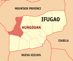
Basisdaten
Bezirk: Regierungsbezirk Cordillera
Provinz: Ifugao
Barangays: 9
Distrikt: 1. Distrikt von Ifugao
PSGC: 142702000
Einkommensklasse: 4. Einkommensklasse
Haushalte: 1699
Zensus 1. Mai 2000
Einwohnerzahl: 9.601
Zensus 1. August 2007
Koordinaten: 16° 50′ N, 121° 0′ O16.833333333333121Koordinaten: 16° 50′ N, 121° 0′ O
Postleitzahl: 3603
Bürgermeister: Pablo Cuyahon
Offizielle Webpräsenz: www.hungduan.gov.ph
Geographische Lage auf den Philippinen
Hungduan (Philippinen)
Hungduan
Hungduan

Hungduan ist eine philippinische Stadtgemeinde in der Provinz Ifugao. Nach dem Zensus vom 1. Mai 2000 hat sie 9380 Einwohner in 1699 Haushalten.

Baranggays

Hungduan ist politisch in neun Baranggays unterteilt.

  • Abatan
  • Bangbang
  • Maggok
  • Poblacion
  • Bokiawan
  • Hapao
  • Lubo-ong
  • Nungulunan
  • Ba-ang

Wikimedia Foundation.

Игры ⚽ Поможем написать курсовую

Schlagen Sie auch in anderen Wörterbüchern nach:

  • Hungduan — 16° 50′ 00″ N 121° 00′ 00″ E / 16.8333, 121 …   Wikipédia en Français

  • Hungduan (Ifugao) — Hungduan Carte d Ifugao avec localisation de Hungduan Hungduan est une municipalité de la province d Ifugao, aux Philippines. Voir aussi Listes des villes des Philippines par province …   Wikipédia en Français

  • Hungduan, Ifugao — Hungduan is a 5th class municipality in the province of Ifugao, Philippines. According to the 2000 census, it has a population of 9,380 people in 1,699 households.BarangaysHungduan is politically subdivided into 9 barangays.* Abatan * Bangbang *… …   Wikipedia

  • PH-IFU — Lage von Ifugao Ifugao ist eine Provinz im Regierungsbezirk Cordillera, auf der Insel Luzón im Norden der Philippinen. Die Hauptstadt der Provinz ist Lagawe. Ifugao dehnt sich auf …   Deutsch Wikipedia

  • Mount Apo — The Grandfather of Philippine Mountains Elevation 2,954 m (9,692 ft)  …   Wikipedia

  • Ifugao — This article refers to the province. For other uses, see Ifugao (disambiguation). Infobox Philippine province name = Ifugao sealfile = Ph seal ifugao.png region = Cordillera Administrative Region (CAR) capital = Lagawe founded = mdash;June 18,… …   Wikipedia

  • Mount Pulag — Elevation 2,922 m (9,587 ft) [1] …   Wikipedia

  • Chocolate Hills — Natural Monument * UNESCO World Heritage Site Country …   Wikipedia

  • El Nido, Palawan — El Nido redirects here. For the small towns in the United States, see El Nido, California (disambiguation). Municipality of El Nido Bayan ng El Nido   1st class municipality   …   Wikipedia

  • Paddy field — A paddy field is a flooded parcel of arable land used for growing rice and other semiaquatic crops. Rice can also be grown in dry fields, but from the twentieth century paddy field agriculture became the dominant form of growing rice. Paddy… …   Wikipedia

Share the article and excerpts

Direct link
Do a right-click on the link above
and select “Copy Link”