KEFD

KEFD
Ellington Field
Satellitenaufnahme des Ellington Airports
Kenndaten
IATA-Code EFD
ICAO-Code KEFD
Koordinaten
Verkehrsanbindung
Entfernung vom Stadtzentrum 24 km südlich von Houston
Straße I-45/TX 3
Basisdaten
Eröffnung
Betreiber City of Houston
Fläche
Flug-
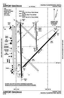
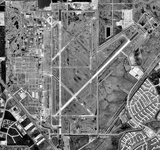
bewegungen
121.270 (Stand: 2005)
Start- und Landebahnen
4/22 2.439 m × 46 m Beton
17L/35R 1.405 m × 23 m Beton
17R/35L 2.744 m × 46 m Beton

Ellington Airport (Ellington Field) wird sowohl als ziviler, als auch als militärischer Flughafen genutzt. Erworben durch die Stadt Houston, Texas im Jahr 1984, unterstützt Ellington Field jetzt die Operationen des US-Militärs, der NASA, der Vereinigten Staaten, und der allgemeinen Luftfahrt.

Der Flughafen wurde 1917 für die Schulung von Piloten der United States Army Air Corps angelegt, wurde zwischenzeitlich von der United States Air Force betrieben und befindet sich mittlerweile im Besitz der Stadt Houston. Am Flugplatz ist einer der größten Flieger-Clubs in Texas stationiert und am Flugplatz werden alljährlich die Flugshows über Houston ausgetragen. Ellington-Feld ist etwa 15 Meilen südlich der Innenstadt von Houston gelegen. Der Flughafen wird durch das Houstoner Flughafensystem betrieben.

FAA Lageplan von Ellington Field (EFD)

Wikimedia Foundation.

Игры ⚽ Поможем написать реферат

Schlagen Sie auch in anderen Wörterbüchern nach:

  • KEFD — ICAO Airportcode f. Houston Ellington Field (Texas; USA) see online …   Acronyms

  • KEFD — ICAO Airportcode f. Houston Ellington Field ( Texas; USA) see online …   Acronyms von A bis Z

  • kef — is. <ər.> 1. Ruhi və ya səhhətcə vəziyyət; hal, əhval. Kefin necədir? Kefini soruşmaq. Bu gün kefim yaxşı deyil. – Böyükxanım Qulamxanın kefini pərt görüb danışdırmağa cürət etmirdi. M. S. O.. <Kərbəlayı Qubad:> Ağanın kefi, əhvalı… …   Azərbaycan dilinin izahlı lüğəti

  • Ellington Field — Infobox Airport name = Ellington Field image width = 220 IATA = EFD ICAO = KEFD FAA = EFD type = Public / Military owner = City of Houston operator = city served = location = Houston, Texas elevation f = 32 elevation m = 10 coordinates =… …   Wikipedia

  • damaq — 1. is. 1. Ağız boşluğunun üst tərəfi. Damaq səsi dilç. – tələffüz edərkən dilin damağa toxunması nəticəsində çıxan səs. Damaq saitləri. 2. Ağız mənasında. Usta papirosu damağına salıb başladı işini. C. M.. Qüdrət iri barmaqları arasındakı… …   Azərbaycan dilinin izahlı lüğəti

  • Texas World War II Army Airfields — Infobox Military Structure name=Texas World War II Army Airfields partof = World War II location= coordinates= caption= type=Army Airfields code= built=1940 1944 builder= materials= height= used= 1940 Present demolished= condition= ownership=… …   Wikipedia

  • Texas Raiders — The Commemorative Air Force’s Gulf Coast Wing Texas Raiders group maintains and flies the former PB 1W / B 17G Flying Fortress named Texas Raiders , which is based at William P. Hobby Airport (KHOU) in Houston, Texas.History of the B 17Almost 75… …   Wikipedia

  • Weightlessness — Zero gravity redirects here. For other uses, see Zero gravity (disambiguation). Zero G redirects here. For other uses, see Zero G (disambiguation). 0G redirects here. For other uses, see 0G (disambiguation). Weightlessness (or zero g) is the… …   Wikipedia

  • Ellington Airport (Texas) — Ellington Airport Ellington Field Joint Reserve Base …   Deutsch Wikipedia

  • Ellington Field — Ellington Field …   Deutsch Wikipedia

Share the article and excerpts

Direct link
Do a right-click on the link above
and select “Copy Link”