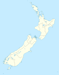
Kaiapoi

Kaiapoi
Kaiapoi
Kaiapoi (Neuseeland)
Kaiapoi
Koordinaten 43° 23′ S, 172° 39′ O-43.381666666667172.65722222222Koordinaten: 43° 23′ S, 172° 39′ O
Einwohner 10.200 (2006)
Region Canterbury
Distrikt Waimakariri-Distrikt

Kaiapoi ist ein Ort auf der Südinsel Neuseelands in der Region Canterbury etwa 15 Kilometer nördlich von Christchurch und bildet mit über 10.000 Einwohnern eine der größten Siedlungen des Waimakariri-Distrikts.

Der Name Kaiapoi stammt aus der Sprache der Māori und bedeutet so viel wie "Nahrungsdepot"; so wurde eine um das Jahr 1700 von den Māori errichtete befestigte Siedlung () genannt, aus der später die heutige Ortschaft hervorging. Insbesondere von 1850 bis 1870 war Kaiapoi ein wichtiges Handelszentrum.

Neben dem Waimakariri River, der nahe der Ortschaft in den Südpazifik mündet, zieht sich noch der Kaiapoi River durch die am State Highway 1 und an der Main North Line gelegenen Stadt.

Persönlichkeiten


Wikimedia Foundation.

Игры ⚽ Поможем решить контрольную работу

Schlagen Sie auch in anderen Wörterbüchern nach:

  • Kaiapoi — Infobox Settlement name = Kaiapoi area total km2 = 5.3098 population as of = 2006 population total = 7410 population density km2 = auto Kaiapoi is a town in the Canterbury region of the South Island of New Zealand, located close to the mouth of… …   Wikipedia

  • Kaiapoi — Original name in latin Kaiapoi Name in other language State code NZ Continent/City Pacific/Auckland longitude 43.37832 latitude 172.64013 altitude 4 Population 10200 Date 2011 08 01 …   Cities with a population over 1000 database

  • Kaiapoi Town — is a soccer club in Kaiapoi, New Zealand.Kaiapoi Town s home ground is Kendall Park located on Island Road on the outskirts of Kaiapoi.External links* [http://www.rsssf.com/tablesn/nz05.html New Zealand 2004/05 Season Results] …   Wikipedia

  • Kaiapoi River — The Kaiapoi River is a minor river of north Canterbury, in New Zealand s South Island. originally called the Cam River , it is a tributary of the Waimakariri River, which it joins at the larger river s estuary.The town of Kaiapoi is situated on… …   Wikipedia

  • Morgan Williams (politician) — Morgan Williams MP Morgan Williams in 1935 Member of the New Zealand Parliament for Kaiapoi In office 1935 – 1946 …   Wikipedia

  • 2010 Canterbury earthquake — For the severe aftershock of 22 February 2011, see 2011 Christchurch earthquake. 2010 Canterbury earthquake …   Wikipedia

  • Christchurch Northern Motorway — Northern Motorway State Highway 1 Route information Maintained by New Zealand Transport Agency …   Wikipedia

  • Norman Kirk — The Right Honourable Norman Eric Kirk Norman Kirk on 2 May 1974 29th Prime Minister of New Zealand …   Wikipedia

  • Eyreton Branch — Infobox rail line name = Eyreton Branch color =6699FF logo width = image width = caption = type = Heavy Rail system = New Zealand Government Railways (NZGR) status = Closed locale = Canterbury, New Zealand start = Kaiapoi end = Bennetts Junction… …   Wikipedia

  • Charles Christopher Bowen — Sir Charles Christopher Bowen KB. KCMG. (29 August 1830 – 12 December 1917) was a 19th century New Zealand politician. Contents 1 Life …   Wikipedia

Share the article and excerpts

Direct link
Do a right-click on the link above
and select “Copy Link”