Waimakariri River

Waimakariri River
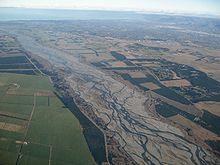
Waimakariri River mit Christchurch im Hintergrund
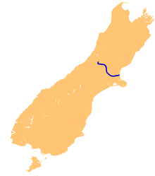
Lage des Waimakariri auf der Südinsel Neuseelands

Der Waimakariri River (in Canterbury "The Waimak") ist der größte Fluss der Region Canterbury auf der Südinsel Neuseelands.

Er fließt über eine Strecke von 151 km aus den Neuseeländischen Alpen in den Pazifik.[1]

Der Fluss entspringt auf der Südseite der Neuseeländischen Alpen, 8 km südwestlich von Arthur’s Pass. Über einen großen Teil des Oberlaufes ist der Fluss ein sogenannter verflochtener Fluss, ein System zahlreicher wechselnder, miteinander verbundener Flussläufe mit breiten Schotterbetten. Beim Zugang zu den Canterbury Plains passiert er einen Gebirgsgürtel und wird dort in einen engen Canyon, die Waimakariri Gorge, gezwängt, bevor er seine frühere Form auf der Ebene wieder aufnimmt. Er mündet nördlich von Christchurch bei Kaiapoi in den Pazifik.

In der Sprache der Māori hat Waimakariri mehrere Bedeutungen, unter anderem "Fluss aus kaltem, rauschendem Wasser". [1]

Geologische Befunde zeigen, dass die Flussmündung sehr mobil war und zeitweise durch das heutige Christchurch, eine Zeitlang sogar in den Lake Ellesmere südlich der Banks-Halbinsel floss.

Der Central Plains Water Trust schlägt vor, an zwei Stellen des Flusses insgesamt 40 m³/s Wasser für das Central-Plains-Water-Wasserversorgungsprojekt zu entnehmen. [2]

Quellen

  1. a b Robert Logan: Waimakariri. The story of Canterbury's "river of cold rushing water". Christchurch: Robert Logan 1987, ISBN 0473005204
  2. Central Plains Water Trust applications for resource consent Website von Environment Canterbury Resource Consent vom 10. Oktober 2007

Wikimedia Foundation.

Игры ⚽ Нужно сделать НИР?

Schlagen Sie auch in anderen Wörterbüchern nach:

  • Waimakariri River — Infobox River river name = Waimakariri River image size = 300px caption = The Waimakariri with Christchurch in the background. origin = Southern Alps mouth = basin countries = New Zealand length = elevation = mouth elevation = 0 metres discharge …   Wikipedia

  • Waimakariri River — River, east central South Island, New Zealand. It rises in the Southern Alps and flows 100 mi (160 km) southeast to Pegasus Bay of the Pacific Ocean. The river s delta constitutes a major portion of the Banks Peninsula and part of the Canterbury… …   Universalium

  • Waimakariri — can refer to a number of geographical features in the province of Canterbury, New Zealand: *The Waimakariri River *The Waimakariri Gorge *The Waimakariri District …   Wikipedia

  • Waimakariri District — The Waimakariri District is a political district of New Zealand, located in the South Island, on the eastern coast of north Canterbury, New Zealand. It is north of Christchurch and the Waimakariri River and is a part of the greater Canterbury… …   Wikipedia

  • Waimakariri Gorge — The Waimakariri Gorge is located on the Waimakariri River in inland Canterbury in New Zealand s South Island.Like its neighbour, the Rakaia River, the Waimakariri runs through wide shingle beds for much of its length, but is forced through a… …   Wikipedia

  • river — river1 riverless, adj. riverlike, adj. /riv euhr/, n. 1. a natural stream of water of fairly large size flowing in a definite course or channel or series of diverging and converging channels. 2. a similar stream of something other than water: a… …   Universalium

  • Crow River (Canterbury) — For the tributary of the Karamea River, see Crow River, West Coast. Crow River Origin Mount Rolleston Mouth Waimakariri River Basin countries New Zealand Length 8 km (5.0 mi) …   Wikipedia

  • Braided River — Luftbild eines verflochtenen Flusses am Zusammenfluss von Yukon River und Koyukuk River in Alaska. Das dunkle Wasser des Koyukuk River (links) mischt sich mit dem silthaltigen hellen Wasser des Yukon River (rechts) …   Deutsch Wikipedia

  • Cust River — Origin Canterbury Plains Mouth Cam River / Ruataniwha Basin countries New Zealand Length 51 kilometres (32 mi) The Cust River is a river in the Canterbury Region of …   Wikipedia

  • White River, New Zealand — The White River is in the South Island of New Zealand.It drains from the eastern flanks of the Southern Alps into the Waimakariri River. It is accessible by getting to Klondike Corner on State Highway 73, following the Waimakariri up to… …   Wikipedia

Share the article and excerpts

Direct link
Do a right-click on the link above
and select “Copy Link”