Karoonda East Murray Council

Karoonda East Murray Council
District Council of Karoonda East Murray
Australia-Map-SA-LGA-Karoonda.png
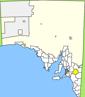
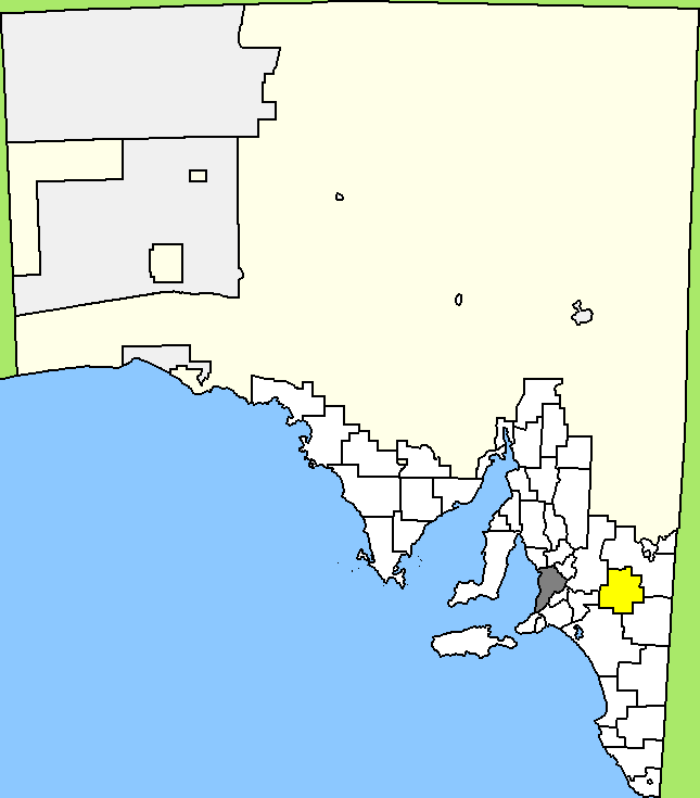
Lage des Karoonda East Murray Council in South Australia
Gliederung
Staat: Australien Australien
Bundesstaat: Flag of South Australia.svg South Australia
Verwaltungssitz: Karoonda
Daten und Zahlen
Fläche: 4.415 km²
Einwohner: 1.163 (2006) [1]
Bevölkerungsdichte: 0,3 Einwohner je km²
Wards: 4
-35.1139.9

Der District Council of Karoonda East Murray ist ein lokales Verwaltungsgebiet (LGA) im australischen Bundesstaat South Australia. Das Gebiet ist 4415 km² groß und hat etwa 1200 Einwohner.

Karoonda East Murray liegt inmitten der Murray Lands etwa 120 Kilometer östlich der Metropole Adelaide. Das Gebiet beinhaltet 26 Ortsteile und Ortschaften: Auld, Bakara, Bandon, Borrika, Bowhill, Chesson, Copeville, Galga, Halidon, Hooper, Kalyan, Karoonda, Lowaldie, Mantung, Marama, Marmon Jabuk, McPherson, Mercunda, Mindarie, Molineux, Perponda, Sandalwood, Vincent, Wanbi, Wilson und Wynarka. Der Verwaltungssitz des Councils befindet sich in Karoonda im Norden des lokalen Verwaltungsgebiets.

Verwaltung

Der Council von Karoonda East Murray hat neun Mitglieder, acht Councillor werden von den Bewohnern der vier Wards gewählt (je zwei aus East Murray, Hooper, Karronda und Molineux Ward). Diese vier Bezirke sind unabhängig von den Stadtteilen festgelegt. Der Ratsvorsitzende und Bürgermeister wird zusätzlich von allen Bewohnern des Districts gewählt.

Weblinks

Einzelnachweise

  1. Australian Bureau of Statistics (25. Oktober 2007): Karoonda East Murray (DC) (Local Government Area) (Englisch). 2006 Census QuickStats. Abgerufen am 6. April 2010.

Wikimedia Foundation.

Игры ⚽ Поможем написать реферат

Schlagen Sie auch in anderen Wörterbüchern nach:

  • District Council of Karoonda East Murray — South Australia Location of the District Council of Karoonda East Murray …   Wikipedia

  • Mid Murray Council — South Australia Location of the Mid Murray Council in SA Population …   Wikipedia

  • Karoonda, South Australia — Infobox Australian Place | type = town name = Karoonda state = sa caption = Main Street of Karoonda lga = District Council of Karoonda East Murray postcode = 5307 est = pop = 514 [Census 2006 AUS|id=SSC43871|name=Karoonda (State… …   Wikipedia

  • Karoonda meteorite — The Karoonda meteorite fell to earth on November 25 1930 at 10:53 pm near the South Australian town of Karoonda. [cite web url = http://www.dckem.sa.gov.au/site/page.cfm?u=169 title = Karoonda Meteorite| accessdate = 2007 01 15| date = 11 January …   Wikipedia

  • Southern Mallee District Council — South Australia The position of Southern Mallee District Council in SA. Populatio …   Wikipedia

  • Rural City of Murray Bridge — Infobox Australian Place | type = lga name = Rural City of Murray Bridge state = sa caption = Position of the Rural City of Murray Bridge in SA pop = area = est = coordinates = coord| 35.1186|139.2838|display=inline,title|region:AU SA type:adm2nd …   Wikipedia

  • The Coorong District Council — Coorong District Council South Australia Location of the Coorong District Council Population: 5 …   Wikipedia

  • District Council of Loxton Waikerie — South Australia Location of the District Council of Loxton Waikerie Population …   Wikipedia

  • District Council of Grant — South Australia Location of the District Council of Grant Population: 8,652( …   Wikipedia

  • Wattle Range Council — South Australia Position of the Wattle Range Council Population …   Wikipedia

Share the article and excerpts

Direct link
Do a right-click on the link above
and select “Copy Link”