Kayak Island

Kayak Island

Vorlage:Infobox Insel/Wartung/Höhe fehlt

Kayak Island
Kap Saint Elias auf Kayak Island
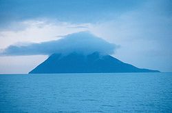
Gewässer Pazifischer Ozean
Geographische Lage 59° 56′ N, 144° 22′ W59.934167-144.368333Koordinaten: 59° 56′ N, 144° 22′ W
Kayak Island (Alaska)
Kayak Island
Länge 32 km
Breite 3 km
Fläche 73,7 km²
Einwohner (unbewohnt)

Die Insel Kayak Island im Golf von Alaska befindet sich etwa 100 km südöstlich von Cordova. Sie hat eine Fläche von 73,7 km² und ist unbewohnt.

Leutnant Sarichef der Russischen Marine benannte die Insel im Jahr 1826 Kayak wegen des Umrisses, der an die Kajaks der Eskimos erinnerte. Kapitän James Cook landete hier an 12. Mai 1778.

Das Kap Saint Elias befindet sich am südwestlichen Ende der Insel. Der Berg Mount Saint Elias wurde wahrscheinlich nach dem Kap benannt.

Der Leuchtturm Cape St. Elias Light ist eine bedeutende Navigationshilfe für die Seefahrt rund um das Eiland.

Die Landestelle Berings ist unter dem Namen „Bering Expedition Landing Site“ seit 1978 als offizielle historische Stätte in die Liste der National Historic Landmarks eingetragen.

Weblinks


Wikimedia Foundation.

Игры ⚽ Поможем написать реферат

Schlagen Sie auch in anderen Wörterbüchern nach:

  • Kayak Island — Infobox nrhp | name =Bering Expedition Landing Site nrhp type = nhl caption = location= Katalla, Alaska lat degrees = 59 lat minutes = 53 lat seconds = 40 lat direction = N long degrees = 144 long minutes = 29 long seconds = 8 long direction = W… …   Wikipedia

  • Kayak for a Cause — is a non profit kayaking fundraiser that takes place annually on Long Island Sound on the eastern coast of the United States. A group of several hundred kayakers cross the Sound from Norwalk, Connecticut to the north shore of Long Island and… …   Wikipedia

  • Island Beach State Park — is a New Jersey state park located just south of Seaside Park on the Barnegat Peninsula in Berkeley Township, Ocean County, New Jersey, United States. The park is operated and maintained by the New Jersey Division of Parks and Forestry. Most of… …   Wikipedia

  • Kayak — A kayak is a small human powered boat. It typically has a covered deck, and a cockpit covered by a spraydeck. It is propelled by a double bladed paddle in the hands of a sitting paddler. The kayak was used by the native Ainu, Aleut and Eskimo… …   Wikipedia

  • Île Kayak (Nunavut) — Pour les articles homonymes, voir Île Kayak (Alaska) et Kayak (homonymie). 62° 13′ N 92° 28′ W …   Wikipédia en Français

  • Île Kayak (Alaska) — Pour les articles homonymes, voir Île Kayak (Nunavut) et Kayak (homonymie). 59°56′03″N 144°22′06″O / …   Wikipédia en Français

  • Sea kayak — A sea kayak on Valdes Island, British Columbia, Canada. A sea kayak or touring kayak is a kayak developed for the sport of paddling on open waters of lakes, bays, and the ocean. Sea kayaks are seaworthy small boats with a covered deck and the… …   Wikipedia

  • Grand Island East Channel Light — Infobox Lighthouse caption = Grand Island East Channel light in 2007 location = Munising, Michigan, U.S. coordinates = coord|46|27.01|N|86|37.345|W|region:US type:landmark|display=inline,title yearbuilt = yearlit = 1868 automated =… …   Wikipedia

  • Aleutian kayak — The Aleutian Baidarka or Aleutian kayak was the watercraft created by the native Aleut (or Unangan) people of the Aleutian Islands. The Aleut people were surrounded by treacherous waters and required water transportation and a hunting vessel. Due …   Wikipedia

  • Jackson Kayak — was founded by its namesake, Eric EJ Jackson. After working with Wave Sport Kayaks as a team member and as a designer, EJ and business partner Tony Lunt formed Jackson Kayak in Rock Island, Tennessee in October 2003 Citation last = De La Cruz… …   Wikipedia

Share the article and excerpts

Direct link
Do a right-click on the link above
and select “Copy Link”