Kiamba

Kiamba
Municipality of Kiamba
Lage von Kiamba in der Provinz Sarangani
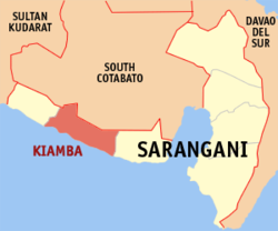
Karte
Basisdaten
Bezirk: SOCCSKSARGEN
Provinz: Sarangani
Barangays: 19
Distrikt: 1. Distrikt von Sarangani
PSGC: 128003000
Einkommensklasse: 2. Einkommensklasse
Haushalte: 9095
Zensus 1. Mai 2000
Einwohnerzahl: 53.040
Zensus 1. August 2007
Koordinaten: 5° 59′ N, 124° 37′ O5.9833333333333124.61666666667Koordinaten: 5° 59′ N, 124° 37′ O
Postleitzahl: 9514
Offizielle Webpräsenz: www.kiamba.gov.ph
Geographische Lage auf den Philippinen
Kiamba (Philippinen)
Kiamba
Kiamba

Kiamba ist eine philippinische Stadtgemeinde in der Provinz Sarangani.

Inhaltsverzeichnis

Geografie

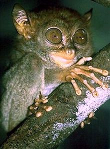
Philippinen-Koboldmaki

Die Stadtgemeinde Kiamba grenzt im Westen an Maitum, im Osten an Maasim, im Norden an South Cotabato. Im Süden liegt die Celebessee.

In den Regenwäldern und den Berggebieten Kiambas lebt der Philippinen-Koboldmaki (Tarsius syrichta).

Baranggays

Kiamba ist politisch in 19 Baranggays unterteilt.

  • Badtasan
  • Datu Dani
  • Gasi
  • Kapate
  • Katubao
  • Kayupo
  • Kling (Lumit)
  • Lagundi
  • Lebe
  • Lomuyon
  • Luma
  • Maligang
  • Nalus
  • Poblacion
  • Salakit
  • Suli
  • Tablao
  • Tamadang
  • Tambilil

Bevölkerung

Die Mehrheit der Einwohner spricht Cebuano, obwohl die frühen Siedler vom Ursprung Ilocanos waren. Eines der indigenen Völker, das in den Bergen Kiambas lebt, sind die T'boli.

Wirtschaft

Die Wirtschaft Kiambas basiert zu großen Teilen auf der Landwirtschaft, ausgedehnte Reisfelder umgeben den Hauptort. Aquakulturen sind die zweitbedeutendste Einkommensquelle, insbesondere Milchfischkulturen und Shrimps (von den Einheimischen sugpo oder lukon genannt) für den Export. In den Küstenorten bildet die Meeresfischerei die wichtigste Einkommensquelle.


Wikimedia Foundation.

Игры ⚽ Нужно решить контрольную?

Schlagen Sie auch in anderen Wörterbüchern nach:

  • Kiamba — Original name in latin Kiamba Name in other language Kiamba, Kiamba Townsite State code PH Continent/City Asia/Manila longitude 5.98944 latitude 124.62417 altitude 12 Population 10979 Date 2011 07 31 …   Cities with a population over 1000 database

  • Kiamba, Sarangani — Kiamba is a 3rd class municipality in the province of Sarangani, Philippines. According to the 2000 census, it has a population of 44,724 people in 9,095 households.It is bordered on the west by Maitum, on the east by Maasim, on the north by… …   Wikipedia

  • Notre Dame of Kiamba — (NDK) is a private school in National Highway, Poblacion, Kiamba, Sarangani [1] run by Marist Brothers. NDK has been a member of the Notre Dame Educational Association, a group of Notre Dame Schools in the Philippines under the patronage of the… …   Wikipedia

  • Sarangani — For the municipality in Davao del Sur, see Sarangani, Davao del Sur. Sarangani   Province   …   Wikipedia

  • Maitum, Sarangani — Maitum   Municipality   Seal …   Wikipedia

  • Manny Pacquiao — Pacquiao redirects here. For Manny Pacquiao s brother, see Bobby Pacquiao. Manny Pacquiao …   Wikipedia

  • Notre Dame of Marbel University — Pamantasang Notre Dame ng Marbel http://www.tufts.edu/talloiresnetwork/images/talnet 142.bmp Motto All to Jesus through Mary Established Foundation1951 University Status …   Wikipedia

  • Notre Dame of Dadiangas University — Pamantasang Notre Dame ng Dadiangas Motto School: Ad laudem atque Education Human Integrity Marist: Ad Jesum Per Mariam Motto in English …   Wikipedia

  • Marist School (Marikina) — Marist School Marikina Location 50 Champagnat St., Marikina Heights Marikina City Philippines Information Type Private Catholic School Motto Ad Jesum per Mariam (All …   Wikipedia

  • Maasim — Municipality of Maasim Lage von Maasim in der Provinz Sarangani Basisdaten Bezirk …   Deutsch Wikipedia

Share the article and excerpts

Direct link
Do a right-click on the link above
and select “Copy Link”