- Lady Elliot Island
-
Die Lady-Elliot-Insel ist die südlichste Koralleninsel des Großen Barriere-Riffs vor Australiens Ostküste. Sie liegt 80 km nordöstlich von Bundaberg im australischen Bundesstaat Queensland. Die Insel ist etwa 0,6 km² groß.
Inhaltsverzeichnis
Geschichte
Die Lady-Elliot-Insel wurde 1816 entdeckt und nach dem Schiff des Entdeckers benannt. Seit 1970 ist sie für den Tourismus erschlossen, wobei man versucht, die Natur so weit wie möglich zu schonen. Ein Drittel der Insel ist Vogelschutzgebiet und darf nicht betreten werden.
Tourismus
Auf dem restlichen Teil der Insel dürfen sich auch nie mehr als ca. 120 Personen gleichzeitig aufhalten. Im Südosten der Insel liegt ein kleines, komfortables Ferienresort und eine Landebahn für Kleinflugzeuge. Die Anreise erfolgt von Bundaberg, Hervey Bay und neuerdings Gladstone jeweils ausschließlich per Flugzeug.
Die Insel ist insbesondere für Unterwassersportler interessant. Von Oktober bis Dezember ist Brut-/Schlüpfzeit für Meeresschildkröten. Auch Wale können dort gelegentlich beobachtet werden.
Vogelbilder
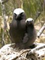
Noddi mit Nestling
Weblinks
- Website - Lady Elliot Island (englisch)
- Interaktive Luftbildaufnahme von Lady Elliot Island (englisch)
-24.1167152.7167Koordinaten: 24° 7′ S, 152° 43′ O


Wikimedia Foundation.