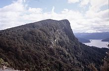
- Lake Waikaremoana Great Walk
-
Der 43 Kilometer lange Lake Waikaremoana Great Walk verläuft am Süd- und Westufer des Lake Waikaremoana im Te Urewera National Park auf der Nordinsel von Neuseeland.
Der offiziell als New Zealand Great Walk klassifizierte Wanderweg erlaubt während seines Verlaufs durch verschiedene Typen von Wäldern und offenen Wiesenflächen öfter Ausblicke auf den See. Der Pfad verläuft teilweise über privaten Grund und berührt das Kiwi-Schutzgebiet auf der Puketukutuku-Halbinsel.
Ausgangspunkte der Wanderung sind Onepoto am Süd- und Hopuruahine am Nordende des Sees. Die meisten Benutzer bewältigen den Weg in 3 bis 4 Tagen.
Praktische Hinweise
Die nächste Stadt ist Wairoa (60 km nordwestlich), von dort verkehren bei Bedarf Shuttlebusse zum See. Da es sich nicht um eine Rundstrecke handelt, ist ein Transport durch lokale Bus- oder Bootsunternehmer erforderlich. Alle Hütten und Campingplätze (bis auf die Panekiri Hut auf dem Panekiri Bluff) sind per Boot erreichbar.
Beide Endpunkte liegen am State Highway 38, der auch Zugang zum See mit eigenen Booten bietet. Nahe dem Besucherzentrum Aniwaniwa Visitor gibt es bei Home Bay (Whanganui o parua Inlet) einen Stellplatz für Wohnmobile.
Ganzjährig ist eine Reservierungsbuchung erforderlich, die Übernachtungsgebühren pro Person und Nacht sind zur Zeit NZ$ 25.00 für Hütten und NZ$ 12.00 für Zeltplätze.
Weblinks
-38.766666666667177.08333333333Koordinaten: 38° 46′ 0″ S, 177° 5′ 0″ OAbel Tasman Coast Track | Heaphy Track | Kepler Track | Lake Waikaremoana Great Walk | Milford Track | Rakiura Track | Routeburn Track | Tongariro Northern Circuit | Whanganui Journey
Wikimedia Foundation.
Schlagen Sie auch in anderen Wörterbüchern nach:
Lake Waikaremoana Great Walk — The Waikaremoana Great Walk is a 43 kilometre tramping track which follows the southern and western coast of Lake Waikaremoana in the North Island of New Zealand. Passing through several types of forest, and grassland, track often provides… … Wikipedia
Lake Waikaremoana — Geographische Lage Wairoa Distrikt, Hawke’s Bay, Neuseeland Größere Städte in der Nähe … Deutsch Wikipedia
Lake Waikaremoana — Infobox lake lake name = Lake Waikaremoana image lake = Lake Waikaremoana sun set.jpg caption lake = image bathymetry = caption bathymetry = location = Wairoa District, Hawke s Bay Region, North Island coords = coord|38|46|S|177|05|E|region:NZ… … Wikipedia
Great Walks — Logo Als Great Walks (offiziell: New Zealand Great Walks) wird eine Reihe von Wanderwegen in Neuseeland bezeichnet. Die Great Walks gehören zu den wichtigsten und bedeutendsten Wanderwegen des Landes und führen durch die schönsten Gegenden auf… … Deutsch Wikipedia
New Zealand Great Walks — Map of the Great Walks of New Zealand One of many beaches on the Abel Tasma … Wikipedia
Milford Track — Mitre Peak, Milford Sound Length 53.5 km (33.2 mi) Location Fiordland National Park, Southland, New Zealand Designation … Wikipedia
Abel Tasman Coastal Track — Brücke über einen Flusslauf entlang des Abel Tasman Coast Track Einer der zahlreichen Strände auf dem Weg Der Abel Tasman Coast Track ist ein 51 Kilometer langer Wanderweg von Marahau im Süden … Deutsch Wikipedia
New Zealand tramping tracks — Main article: Tramping in New Zealand A Department of Conservation track marker an orange triangular plastic pointer attached to trees and poles. In New Zealand, long distance walking or hiking for at least one overnight stay is known as tramping … Wikipedia
Milford Track — Logo Wasserfall am Milford Track … Deutsch Wikipedia
Tongariro Northern Circuit — Logo … Deutsch Wikipedia


