Lake Waikaremoana

Lake Waikaremoana
Lake Waikaremoana
Lake Waikaremoana.jpg
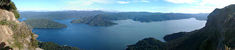
Geographische Lage Wairoa-Distrikt, Hawke’s Bay, Neuseeland
Größere Städte in der Nähe Wairoa, Gisborne
Daten
Koordinaten 38° 46′ 0″ S, 177° 5′ 0″ O-38.766666666667177.08333333333600Koordinaten: 38° 46′ 0″ S, 177° 5′ 0″ O
Lake Waikaremoana (Neuseeland)
Lake Waikaremoana
Höhe über Meeresspiegel 600 m
Fläche 54 km²dep1f5
Maximale Tiefe 248 mdep1f10

Der Lake Waikaremoana ist ein See im Te-Urewera-Nationalpark an der Ostküste der neuseeländischen Nordinsel. Er entstand vor 2200 Jahren durch einen Erdrutsch, durch den der Waikaretaheke River aufgestaut wurde. Entlang seines Süd- und Westufers verläuft der Lake Waikaremoana Great Walk, einer der New Zealand Great Walks.

Weblinks

 Commons: Lake Waikaremoana – Sammlung von Bildern, Videos und Audiodateien

Wikimedia Foundation.

Игры ⚽ Поможем написать реферат

Schlagen Sie auch in anderen Wörterbüchern nach:

  • Lake Waikaremoana — Infobox lake lake name = Lake Waikaremoana image lake = Lake Waikaremoana sun set.jpg caption lake = image bathymetry = caption bathymetry = location = Wairoa District, Hawke s Bay Region, North Island coords = coord|38|46|S|177|05|E|region:NZ… …   Wikipedia

  • Lake Waikaremoana Great Walk — Logo Panekiri Bluff …   Deutsch Wikipedia

  • Lake Waikaremoana Great Walk — The Waikaremoana Great Walk is a 43 kilometre tramping track which follows the southern and western coast of Lake Waikaremoana in the North Island of New Zealand. Passing through several types of forest, and grassland, track often provides… …   Wikipedia

  • Waikaremoana, Lake — ▪ lake, New Zealand       lake in eastern North Island, New Zealand. Created by a landslide damming the Waikare Taheke River, the 21 square mile (54 square kilometre) lake, measuring 12 miles (19 km) by 6 miles (10 km), drains a 165 square mile… …   Universalium

  • Lake Waikareiti — Infobox lake lake name = Lake Waikareiti image lake = caption lake = image bathymetry = caption bathymetry = location = Wairoa District, Hawke s Bay Region, North Island coords = type = inflow = outflow = Aniwaniwa Stream catchment = basin… …   Wikipedia

  • Lac Waikaremoana — Lake Waikaremoana Administration Pays …   Wikipédia en Français

  • Lago Waikaremoana — País  Nueva Zelanda Superficie …   Wikipedia Español

  • Te Kooti's War — Infobox Military Conflict partof=New Zealand land wars date=1800 s place=New Zealand result=European Victory combatant1=UK European Settlers Maori combatant2=Maori from July 1868 until mid 1872. It was the longest and in some ways the ugliest and …   Wikipedia

  • Great Walks — Logo Als Great Walks (offiziell: New Zealand Great Walks) wird eine Reihe von Wanderwegen in Neuseeland bezeichnet. Die Great Walks gehören zu den wichtigsten und bedeutendsten Wanderwegen des Landes und führen durch die schönsten Gegenden auf… …   Deutsch Wikipedia

  • Wairoa-Distrikt — Wairoa District Council Karte Basisdaten Region …   Deutsch Wikipedia

Share the article and excerpts

Direct link
Do a right-click on the link above
and select “Copy Link”