- Lantawan
-
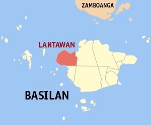
Municipality of Lantawan Lage von Lantawan in der Provinz Basilan 
Basisdaten Bezirk: Autonomous Region in Muslim Mindanao Provinz: Basilan Barangays: 35 Distrikt: 1. Distrikt von Basilan PSGC: 150703000 Einkommensklasse: unbekannt (1-6) Haushalte: 5205 Zensus 1. Mai 2000Einwohnerzahl: 28.978 Zensus 1. August 2007Koordinaten: 6° 42′ N, 121° 43′ O6.70553121.71478Koordinaten: 6° 42′ N, 121° 43′ O Postleitzahl: 7301 Geographische Lage auf den Philippinen 

Lantawan Lantawan ist eine philippinische Stadtgemeinde in der Provinz Basilan. Sie hat 27.487 Einwohner in 5205 Haushalten (Zensus 1. Mai 2000).
Baranggays
Lantawan ist politisch unterteilt in 35 Baranggays.
- Atong-atong
- Baluk-baluk
- Baungis
- Bulanza
- Dasalan
- Lantawan Proper (Pob.)
- Lower Manggas
- Lubukan
- Luukbongsod
- Matarling
- Matikang
- Panducan
- Tausan
- Tairan
- Upper Manggas
- Bagbagon
- Bulan-bulan
- Palahangan
- Suba-an (Pangasahan)
- Sangbay Big
- Sangbay Small
- Lower Baas
- Upper Baas
- Calugusan
- Canibungan
- Landugan
- Lawila
- Lawi-lawi
- Mananggal
- Pamucalin
- Switch Yakal
- Paniongan
- Luuk-Maluha
- Calayan
- Parian-Baunoh
Städte und Stadtgemeinden in der Provinz BasilanStädte: Isabela City | Lamitan City
Stadtgemeinden: Akbar | Al-Barka | Hadji Mohammad Ajul | Hadji Muhtamad | Lantawan | Maluso | Sumisip | Tabuan-Lasa | Tipo-Tipo | Tuburan | Ungkaya Pukan
Wikimedia Foundation.
Schlagen Sie auch in anderen Wörterbüchern nach:
Lantawan — Carte de Basilan avec localisation de Lantawan Lantawan est une municipalité de la province de Basilan, aux Philippines. Voir aussi Listes des villes des Philippines par province … Wikipédia en Français
Lantawan (Basilan) — Lantawan Carte de Basilan avec localisation de Lantawan Lantawan est une municipalité de la province de Basilan, aux Philippines. Voir aussi Listes des villes des Philippines par province … Wikipédia en Français
Lantawan, Basilan — Lantawan is a 4th class municipality in the province of Basilan, Philippines. According to the 2000 census, it has a population of 18,206 people in 3,446 households. On August 25, 2007, 10 of its barangays were constituted into the separate… … Wikipedia
Basilan — Infobox Philippine province name = Basilan sealfile = ph seal basilan.png|100px region = Autonomous Region in Muslim Mindanao (ARMM) capital = Isabela City (Zamboanga Peninsula) founded = December 27, 1973 pop2000 = 496,503 pop2000rank = 20th… … Wikipedia
History of Basilan — Pre Hispanic TaguimaBasilan s earliest settlers were the Orang Dampuans originating from the islands of Eastern Indonesia, who were the ancestors of the native Yakans. They are variously called the Orang Dyaks or the Tagihamas.The Yakans, an… … Wikipedia
Isnilon Totoni Hapilon — Infobox Person name =Isnilon Totoni Hapilon image size =150x200px caption =Abu Sayyaf Group member birth date =March 18, 1966 birth place =Basilan, the Philippines death date = death place = occupation = spouse = parents = children =Isnilon… … Wikipedia
Magdiwang, Romblon — This article is about the Philippine municipality. For other uses, see Magdiwang (disambiguation). Map of Romblon showing the location of Magdiwang Magdiwang is a 5th class municipality in the province of Romblon, Philippines. According to the… … Wikipedia
Hadji Muhtamad — Municipality of Hadji Muhtamad Basisdaten Bezirk: Autonomous Region in Muslim Mindanao Provinz: Basilan Barangays … Deutsch Wikipedia
Lamitan — City of Lamitan Lungsod ng Lamitan Lage von Lamitan City in der Provinz Basilan Basisdaten Bezirk: Autonomous Region in Muslim Mindanao … Deutsch Wikipedia
PH-BAS — Lage von Basilan. Basilan (auch Taguima) ist eine Insel im Süden der Philippinen und ein Teil des Sulu Archipels, vier Fünftel von ihr bilden die gleichnamige Provinz des Inselstaates. Die Insel wird durch die Straße von Basilan von Zamboanga… … Deutsch Wikipedia
Lantawan

18+
© Academic, 2000-2026
- Kontaktieren Sie uns: Unterstützung, Werbung
Wörterbücher Export, schritte mit PHP, Joomla, Drupal, WordPress, MODx.